
In the middle of a whole bucket of nope comes a ray of light; a glimmer of nope… I mean hope.
Currently a large low pressure system is sliding through Ontario and will slide northeast through Quebec overnight. I don’t need to tell you that this has resulted in less than stellar weather today. Currently it’s raining with strong southerly winds.
A trailing cold front associated with the parent low will push through the region early tomorrow morning. Unlike the last few fronts, this one will not be a freight-train of dry arctic air. As I said in this post a few days ago, with a more zonal flow setting up for the next few days, this rain event won’t be followed by a harsh blast from the Polar Vortex. Instead of being cold as ice, after the parent low pulls out, at around 7 am on Sunday, temps should be about 0C at 1500ft and -8c across the summits.
At the same time, a fair amount of moisture will be spun in from the flow around the parent low.
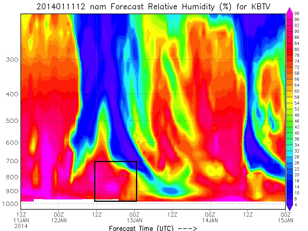
Looking at the basic upslope parameters indicates that a period of decent upslope snow is possible from 12z (7am) through 00Z(7pm) tomorrow in the northern Greens.
We have good low level saturation of the airmass:
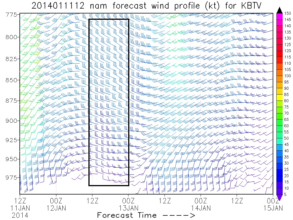
At the same time winds are predicted to come from the 270-290 range….which is pretty much ideal for orographic uplift along the greens:
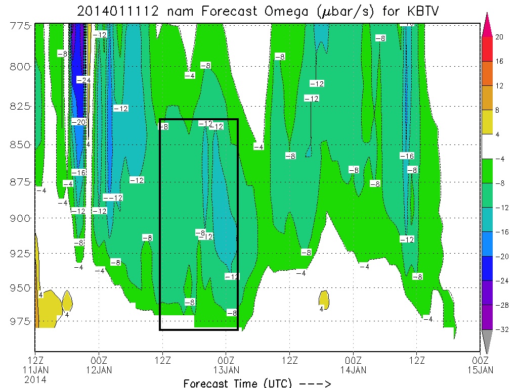
This results is sufficient uplift in the critical 900mb to 850mb layer:
As a result, models are putting out a fairly robust total QPF for the period up by Jay.
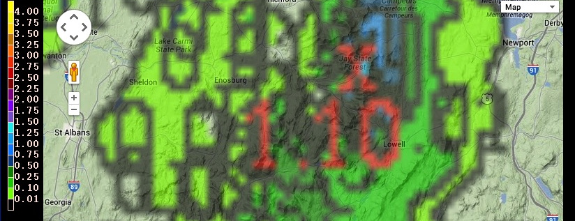
That 1.10″ is MELTED liquid mind you… not total snowfall. Hopefully I don’t need to tell you that 1.10″ of liquid can make a lot of snow!
Now now chaps and chappetes, let us not blow our load too much here. Two things bother me.
1) The atmosphere at 700mb never really reaches the critical saturation level of 70%. It is progged to get close. High 60s%. Which is enough for some upslope snow to develop. But the system REALLY cranks when we get that mid level air saturated above 70%. At drier levels, rising air tends to dry out and snow amounts get cut down as dendritic growth is cut down.
2) The Froude number is a progged at a very robust 1.86 and 2.04 for a period tomorrow per the experimental models run by NWSBTV. Numbers that high indicate that the flow over the spine could be unblocked. We need some blocking of the flow to create the cycle of rising air that makes upslope snow. Unblocked flows tend to make for flurries as opposed to big pows. Now, I think the numbers are a bit high. I don’t see the ripping winds that are normally associated with unblocked flows at 850mb.
With those two issues addressed, I wouldn’t bat an eye at 4-6″ along the northern Green Mountains with pockets of 10 possible up at Jay Peak which is closest to the moisture, has the best chance at being coldest, and is the best at providing a block (to counteract the high Froude number).
So lets watch and see what happens!

4 Comments
Leave a Reply to I'm_a_crappy_skier
|
|||
| Home |

-
Search
New Comments
macbook repair seattle said: “macbook repair seattle Let’s get it started...(read more)” about Let’s get it started
Greg said: “Thanks for all this great info. And...(read more)” about Skiing Mt. Colden’s Trap Dike
Greg said: “Definitely late, but always welcome!” about Skiing Mt. Colden’s Trap Dike
Bob said: “[* Shield Security plugin marked this comment...(read more)” about Skiing Mt. Colden’s Trap Dike
Regular paint Maintenance said: “Regular paint Maintenance Behind The Schuss(ic) :...(read more)” about Behind The Schuss(ic)
The 2012-13 Ski Season in Photos #13 | NY Ski Blog said: “[…] tweeting about big Memorial Day snow...(read more)” about pow
ml242 said: “LuckyLuc and MadPat on the same day?...(read more)” about Deep Cover Anthropology
Talbert said: “Long time no comment..... But great to...(read more)” about Man of Many Moods
Twitter Feed
-
Categories
- Skiing (438)
- Weather (188)
- WTF (5)
- Quick Update (173)
- Full Trip Report (165)
- WebiGNARs (45)
- General Interest (38)
- Site News (27)
- Summer (59)
- Hiking (26)
- Swimming (15)
- Climbing (13)
- Longboarding (3)
- Whitewater Kayaking (2)
- Mountain Biking (1)
- SPA (16)
- Gear Review (8)
-
Archive
- October 2018
- June 2017
- November 2016
- October 2016
- March 2016
- January 2016
- October 2015
- February 2015
- January 2015
- December 2014
- November 2014
- October 2014
- September 2014
- July 2014
- April 2014
- March 2014
- February 2014
- January 2014
- December 2013
- November 2013
- October 2013
- September 2013
- August 2013
- June 2013
- May 2013
- April 2013
- March 2013
- February 2013
- January 2013
- December 2012
- November 2012
- October 2012
- September 2012
- August 2012
- July 2012
- June 2012
- May 2012
- April 2012
- March 2012
- February 2012
- January 2012
- December 2011
- November 2011
- October 2011
- September 2011
- August 2011
- July 2011
- June 2011
- May 2011
- April 2011
- March 2011
- February 2011
- January 2011
- December 2010
- November 2010
- October 2010
- September 2010
- August 2010
- July 2010
- June 2010
- May 2010
- April 2010
- March 2010
- February 2010
- January 2010
- December 2009
- November 2009
- October 2009
- September 2009
- August 2009
- July 2009
- June 2009
- April 2009
- March 2009
- February 2009
- January 2009
- December 2008
- November 2008
- October 2008
- April 2008
- March 2008
- February 2008
-
Friends of F.I.S.

About Us:
We are a group of powder hungry, east-coast-bred, world-traveling skiers and riders who Earn Our Turns to bring you the best stoke a click-of-the-mouse can buy.We hope our adventures inspire you to Earn Your Turns as well!
LEARN MORE

Latest Weather
When one makes meatballs, one must begin with quality meats: ...
Read more in: Meatballs! (read more)
Anonymous
wrote on January 11th, 2014 at 5:40 pmThanks for the glimmer of ?? its much need and very appreciated ?
I'm_a crappy_skier
wrote on January 13th, 2014 at 7:10 pm18th Sir???? What does thy analytical crystal ball say?
Greg
wrote on January 14th, 2014 at 9:09 amG not LH here… lots of SW winds this week. in a “normal” year I’d say it looks good. the way this year is going though, any precip on a SW wind seems to come in as premature-snow… so my take is: “nope”
we’ll see though. would love to be wrong
I'm_a_crappy_skier
wrote on January 15th, 2014 at 10:30 amI hate premature-snow. Thx. Some talk earlier in the week an event may happen. Oh well. Fun times will be had anyway