
Cool it Bro. Seasonal Cold Air to Return. UPDATED: Potential Major Winter Storm “Delta”
Been a bit warm around these parts. Or so I’ve heard. I’ve been too busy sacrificing goats and virgins to Ullr to pay attention. And maybe it worked out as it looks like we’ll have the return to a more seasonal pattern over the next ten days.
But first, a few thoughts on the near term weather this week.
Currently there is a cold front off to the west. This will push through the region sometime tomorrow. Moisture out front will fall as rain. YAY! The front SHOULD stall somewhere to the south and east running through southern NY, Mass and NH. Following that, a weak wave of energy will ride along and bring some light snow showers to the higher terrain.
A second stronger wave looks to develop sometime Wednesday. This is the wave i’ve been hinting at for a while now on twitter and facebook. Last week this wave looked like it wanted to develop into nice little snow maker for us. Now it doesn’t look so good. Looks like it stays open and passes to the south and east. Only really bringing snows to Maine if that. However, I’d like to add that until we see where this front stalls and where this wave develops late Tuesday, further meaningful analysis should be withheld.
UPDATE UPDATE UPDATE:
With the front’s location and timing starting to get resolved the major weather models are displaying some really interesting and noteworthy solutions. As of today, tuesday here’s the basic set up.
Sometime a 500mb trough moving over the carolina piedmont will spark the development of a surface low. This low will ride up and as the trough becomes negatively tilted with height somewhere over NJ/NY the low will rapidly depen and begin to occlude.
Once the low develops the pattern will look like this (trying a new image editor…and I don’t like it…anyway)

So lets follow along. The black lines represent the position of the H5 trough first on wednesday when it’s deeply dug into the south and then more importantly, on thursday when it’s taken a negative around Delaware. (Editors note: I spent like a good 30 minutes figuring out the joke for “negative tilt” and “Delaware” and didn’t come up with anything but I know there is a Lolz in there). Anyway, the steep trough will spark a low to develop and ride along the frontal boundary…marked as a blue line.
By EARLY thursday morning the low will have reached the NY/Conn region and intensified sucking nice wet maritime air in from the ocean (green arrow) and pulling cold air in from the northwest (blue arrows). The result….is potentially heavy snow in the catskills, Berkshires and south NH. Again.
Here are two of the latest total water outputs:

and

That is excellent.
So what’s my take? Well I think the dead bullseye right now is the Berkshires where upwards of 1-2 feet of snow could fall. THere should be a similar strip of heavy snow extending back through the catskills and then on into southern NH. The caveat here is that THE THERMAL PROFILE HAS TO STAYS COLD ENOUGH. I know that’s a platitude but it’s true. Right now there is some doubt in my mind that the models are handling the temperature of this system properly. ITS very possible that much of this qpf falls as heavy mixed precip. The Albany NWS certainly has taken this approach and it has merit. I’m being hopeful and going with what Ullr has shown us he wants to do….not more than 6 weeks ago a storm with a similar track just dropped BOMBS on this region and I trust the past until proven otherwise.
North of that – in southern VT I think we could see 6-9 inches of snow with 3-5 north along the spine with Rutland being the dividing line between the 6-9 band to the south and the 3-5 totals to the north. However by the time we get all the way up to Route 2 don’t expect too much. At least that’s how it looks now.
Over in the NH we’ll see heavy snow in southern NH with the possibility for MT. Wash, if this pivots just a touch more to the NW to get into the 1-2 foot band easy.
Like much of Nor. VT, the ADK – and esp. the High Peaks – look to be hung out mostly dry for this event.
Beyond Delta, over the weekend we will likely get a shot of reinforcing cold air and possibly tap some great lakes moisture for an upslope event. But that’s a ways off and I need to address the REALLY long range first.
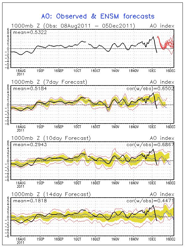
Looking LONG term, the forecast looks more wintery than it has in months. Currently the NAO, AO and PNA are all in just about the worst state for EC cold and snow. However, as show below, the ensemble forecasts for all three teleconnections show a return to a more neutral state. (red lines are individual forecasts of the ensemble system)
AO
NAO

PNA

So while I can’t say we’re going to pow-town or in store for any dy-no-mite events, a neutral state at this time of year at least comes with cold temps supportive of snow (natural or man-made).
All the major operational computer models are also showing run to run consistency depicting a more seasonal zonal pattern. At this point, I’ll take it. So there we have it. Lets see where it goes from here and remember: It could be a lot worse.

7 Comments
|
|||
| Home |

-
Search
New Comments
macbook repair seattle said: “macbook repair seattle Let’s get it started...(read more)” about Let’s get it started
Greg said: “Thanks for all this great info. And...(read more)” about Skiing Mt. Colden’s Trap Dike
Greg said: “Definitely late, but always welcome!” about Skiing Mt. Colden’s Trap Dike
Bob said: “[* Shield Security plugin marked this comment...(read more)” about Skiing Mt. Colden’s Trap Dike
Regular paint Maintenance said: “Regular paint Maintenance Behind The Schuss(ic) :...(read more)” about Behind The Schuss(ic)
The 2012-13 Ski Season in Photos #13 | NY Ski Blog said: “[…] tweeting about big Memorial Day snow...(read more)” about pow
ml242 said: “LuckyLuc and MadPat on the same day?...(read more)” about Deep Cover Anthropology
Talbert said: “Long time no comment..... But great to...(read more)” about Man of Many Moods
Twitter Feed
-
Categories
- Skiing (438)
- Weather (188)
- WTF (5)
- Quick Update (173)
- Full Trip Report (165)
- WebiGNARs (45)
- General Interest (38)
- Site News (27)
- Summer (59)
- Hiking (26)
- Swimming (15)
- Climbing (13)
- Longboarding (3)
- Whitewater Kayaking (2)
- Mountain Biking (1)
- SPA (16)
- Gear Review (8)
-
Archive
- October 2018
- June 2017
- November 2016
- October 2016
- March 2016
- January 2016
- October 2015
- February 2015
- January 2015
- December 2014
- November 2014
- October 2014
- September 2014
- July 2014
- April 2014
- March 2014
- February 2014
- January 2014
- December 2013
- November 2013
- October 2013
- September 2013
- August 2013
- June 2013
- May 2013
- April 2013
- March 2013
- February 2013
- January 2013
- December 2012
- November 2012
- October 2012
- September 2012
- August 2012
- July 2012
- June 2012
- May 2012
- April 2012
- March 2012
- February 2012
- January 2012
- December 2011
- November 2011
- October 2011
- September 2011
- August 2011
- July 2011
- June 2011
- May 2011
- April 2011
- March 2011
- February 2011
- January 2011
- December 2010
- November 2010
- October 2010
- September 2010
- August 2010
- July 2010
- June 2010
- May 2010
- April 2010
- March 2010
- February 2010
- January 2010
- December 2009
- November 2009
- October 2009
- September 2009
- August 2009
- July 2009
- June 2009
- April 2009
- March 2009
- February 2009
- January 2009
- December 2008
- November 2008
- October 2008
- April 2008
- March 2008
- February 2008
-
Friends of F.I.S.

About Us:
We are a group of powder hungry, east-coast-bred, world-traveling skiers and riders who Earn Our Turns to bring you the best stoke a click-of-the-mouse can buy.We hope our adventures inspire you to Earn Your Turns as well!
LEARN MORE

Latest Weather
When one makes meatballs, one must begin with quality meats: ...
Read more in: Meatballs! (read more)
TheRave
wrote on December 5th, 2011 at 12:25 pmThanks Lionel. This was just in the nick of time, I was at despair’s doorway. Let’s hope there’s similar good news soon on Utah pulling out of their snow drought. ???
powhounddd
wrote on December 5th, 2011 at 5:30 pmall teh squiggly lines means good? Yay!!
bushman
wrote on December 5th, 2011 at 9:44 pmweekend will be cold enough for a few rock-ski runs to check on twigs needing trimming for later-in-the-season runs (on marked glades that need a little fine-tuning, not raw woods mind you). L, I’d like 6″ Friday night plusfresh 4 Saturday night in upper NEK, please. thanks
I'm a crappy skier
wrote on December 6th, 2011 at 2:02 pmAwesome to hear! but in the meantime please make it stop r%^$ning
Lane
wrote on December 6th, 2011 at 10:09 pmAh man! Jet stream needs to get it together! I want some snow in the Central Greens! I need to ski! Excellent work though LH, you sir, are quite informative.
-City (BTV!) Dwelling Young Professional
powhounddd
wrote on December 6th, 2011 at 10:50 pmThanks for the update Mr. Hutz. Looks like someone will be stoked!!
Whitewoodchuck
wrote on December 7th, 2011 at 10:51 amThanks LH, great work as always!