
The “January Thaw” is coming to stores near you this weekend.
Since December 19 it has been unmitigated winter in the northeast. After a rainy Friday in December, the faceshot machine turned on, VTAH stopped over, the woods opened up, a nor’easter rolled in and and the bottom of the thermometer dropped out and then we had a series of little waves of joy to finish off the party.
Starting Thursday evening however that pattern looks to break. But first we have one more wave of joy. As it stands now a low pressure system will skirt to our north wednesday night. It will push a weak front across the mountains of NY and VT. That front will spark snow across the higher terrain. A few days ago this event wasn’t looking too robust..if it existed at all on the models. However, the latest models are much more interesting. Instead of just a dusting of snow, the higher resolution models are showing something like 2-4″+ of snow. Based on the overall pattern we’ve been in, I support those higher totals particularly up around Jay Peak which has been the real prime spot for these waves of joy.
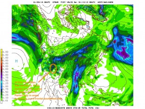
Following that, a ridge will build in to the east coast as the downstream counterpoint to a major trough moving into the west coast. This pattern will center the core of cold air into the intermountain west of the United States. Sorta like this:
The edge of that cold high will create a frontal zone just along the Ohio valley. From Friday through Wednesday, a number of waves will ripple along that boundary. Given that we’ll be on the “warm” side of this baroclinic zone, we’ll see mostly light rain from these weak lows.
The first of these waves will move in Friday bringing some rain to the Northeast, with a break on Saturday into sunday, and then another wave Sunday-Monday, and a last one Tuesday-Wednesday that likely finishes with snow and a pattern change. None of these waves looks like a major rain maker, but each will induce a few showers, some briefly heavy, over the 5 day period.
Now, following this period, it looks COLD. VERY cold in fact. All major models are showing the development of a cold active pattern with summit temps in the -30c range and steady weak low pressure systems moving through the region. With the AO set to tank and the PNA set to return to a positive phase, this has support from key teleconnections. So don’t despair, winter looks poised for a return shortly.
The flip side of this pattern reversal will be snow out west. As the trough moves into the west it will spark snow across the intermountain west. In Utah the front and the following unstable low looks to produce something in the realm of 1-2 feet of new snow from later afternoon Thursday into Saturday.

6 Comments
Leave a Reply
|
|||
| Home |

-
Search
New Comments
macbook repair seattle said: “macbook repair seattle Let’s get it started...(read more)” about Let’s get it started
Greg said: “Thanks for all this great info. And...(read more)” about Skiing Mt. Colden’s Trap Dike
Greg said: “Definitely late, but always welcome!” about Skiing Mt. Colden’s Trap Dike
Bob said: “[* Shield Security plugin marked this comment...(read more)” about Skiing Mt. Colden’s Trap Dike
Regular paint Maintenance said: “Regular paint Maintenance Behind The Schuss(ic) :...(read more)” about Behind The Schuss(ic)
The 2012-13 Ski Season in Photos #13 | NY Ski Blog said: “[…] tweeting about big Memorial Day snow...(read more)” about pow
ml242 said: “LuckyLuc and MadPat on the same day?...(read more)” about Deep Cover Anthropology
Talbert said: “Long time no comment..... But great to...(read more)” about Man of Many Moods
Twitter Feed
-
Categories
- Skiing (438)
- Weather (188)
- WTF (5)
- Quick Update (173)
- Full Trip Report (165)
- WebiGNARs (45)
- General Interest (38)
- Site News (27)
- Summer (59)
- Hiking (26)
- Swimming (15)
- Climbing (13)
- Longboarding (3)
- Whitewater Kayaking (2)
- Mountain Biking (1)
- SPA (16)
- Gear Review (8)
-
Archive
- October 2018
- June 2017
- November 2016
- October 2016
- March 2016
- January 2016
- October 2015
- February 2015
- January 2015
- December 2014
- November 2014
- October 2014
- September 2014
- July 2014
- April 2014
- March 2014
- February 2014
- January 2014
- December 2013
- November 2013
- October 2013
- September 2013
- August 2013
- June 2013
- May 2013
- April 2013
- March 2013
- February 2013
- January 2013
- December 2012
- November 2012
- October 2012
- September 2012
- August 2012
- July 2012
- June 2012
- May 2012
- April 2012
- March 2012
- February 2012
- January 2012
- December 2011
- November 2011
- October 2011
- September 2011
- August 2011
- July 2011
- June 2011
- May 2011
- April 2011
- March 2011
- February 2011
- January 2011
- December 2010
- November 2010
- October 2010
- September 2010
- August 2010
- July 2010
- June 2010
- May 2010
- April 2010
- March 2010
- February 2010
- January 2010
- December 2009
- November 2009
- October 2009
- September 2009
- August 2009
- July 2009
- June 2009
- April 2009
- March 2009
- February 2009
- January 2009
- December 2008
- November 2008
- October 2008
- April 2008
- March 2008
- February 2008
-
Friends of F.I.S.

About Us:
We are a group of powder hungry, east-coast-bred, world-traveling skiers and riders who Earn Our Turns to bring you the best stoke a click-of-the-mouse can buy.We hope our adventures inspire you to Earn Your Turns as well!
LEARN MORE

Latest Weather
When one makes meatballs, one must begin with quality meats: ...
Read more in: Meatballs! (read more)
Duke
wrote on January 9th, 2013 at 11:57 amOn a plane to slc as we speak!
Greg
wrote on January 9th, 2013 at 12:27 pmyou’re going the right way given this weather! git sum for me!! :D
road trip / Gary
wrote on January 9th, 2013 at 2:21 pmSooooo…. potential for 2-4″ (particularly the farther north / higher up you go)? But followed by potential rain on Friday? Ugh….
Keith
wrote on January 11th, 2013 at 8:36 amI love little waves of joy! But I never remember how to convert C – F??? Someone school me again, please.
sbr
wrote on January 11th, 2013 at 3:27 pmThe modern no-math way: go to Google and type in (for example): 25 C to F. The top line of the search results will show the conversion. Works with other forms of measurement and currency as well.
Greg
wrote on January 12th, 2013 at 6:30 amThe math teacher (possibly luddite too) in me requires the following:
1 degree of temperature change in Celsius is equal to 9/5ths (aka 1 and 4/5ths) degrees change in Fahrenheit. If you are estimating in your head, you can pretty much just use 2 instead of 9/5ths. The only other difference between the two systems is 0. As I’m sure you know 0C is the same as 32F. So when you convert you have to add or subtract that 32 difference appropriately.
For instance if you are converting 5C to F. First multiply times 9/5 (or 2 if working in your head) and get 9 (or 10 if you just used 2). Then add 32 to account for the fact that 0C is 32F. The result is 41F (or 42F if you used 2 to work in your head more easily).
If you want to change 42F BACK to C, first subtract 32 degrees essentially to make freezing in both scales = 0. Then DIVIDE by 9/5 which is the same as multiplying by 5/9. (Of course if working in your head, you can just divide by 2).
So for example 42F converts to C as follows: Subtract 32 to get 10. Then divide by 9/5 and get 5.555C. (Note if we worked in our head using 2 and only need an estimate, we would have ended up with 5C. )