
Magic Monday: Retrograding Storm and Broad Cyclonic Flow Brings Snows (Updated)
I’ll get right to the point since I have neither ripped my pants, nor have any witty introductions prepared .
As we speak a large and powerful storm is churning out off the coast of Maine. As I said a week ago, this storm will be forced back towards the west by a large bubble of high pressure – that at the same time will slide out to the east making room for this large storm complex to take up residence over the eastern portions of Canada. As it does this large storm will spin a great deal of air down into the Northeast Untied States on a northwest wind. With a strong pressure gradient these winds will be robust!! A good thing. Strong winds will transport a great deal of moisture both into the North Country and transport a decent amount of moisture down from the Great Lakes into the Catskills (espically the western ones).
Lets look at the North Country first:
With a strong slow moving low pressure system rotating in eastern Canada winds in the North Country will be steady from 290to 320 degress. This is a great direction for the Greens and to a lesser extent the high peaks to induce a good deal or orographic forcing. The models display the best low level upward motion downwind of the Greens (Maps from coolwx.com – a great site) :
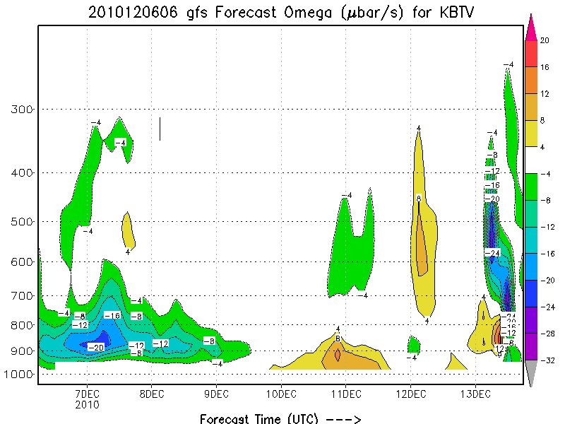
With deep moisture:
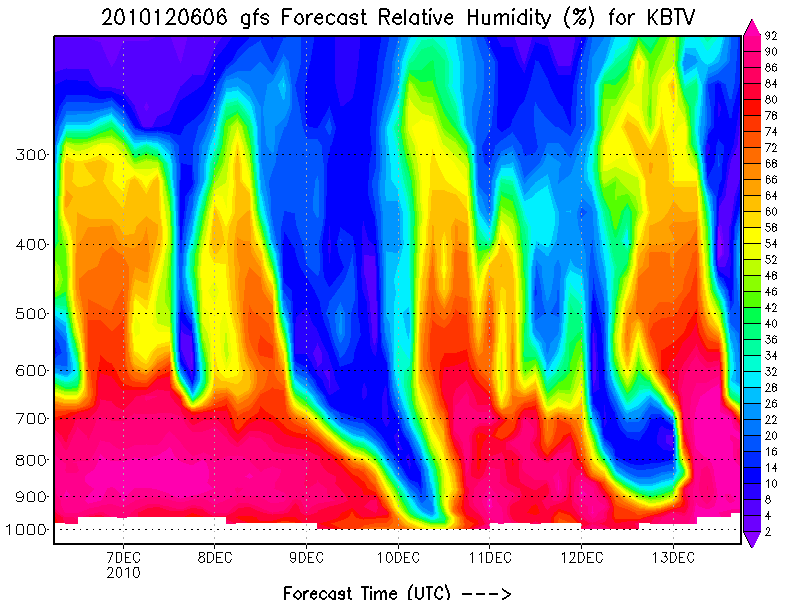
Its very very likely the Northern Greens will see steady snowfall throughout the next 36 hours at the least. The high RES WRF model run out of BTV agrees. It paints the Mansfield massif and Jay Peak with upward to 1 inch of total qpf. With very favorable snow to water ratios I could see a soild 8-9 inches over the next 36 hours in these regions.
The models are also having a hard time with the Adirondack High peaks. The show the northern lower slopes of the Adirondacks taking most of the snow, however based on reports I’ve recieved from the Lake Placid area, several inches have already fallen with blower still falling HARD. Models have a very hard time with the region because of the elevation and somewhat jumbled nature of the High Peaks. Suffice it to say that the ADK will see sustained snow over the next 36 hours with the best accumulations occuring on North and Northwest facing slopes. Comparing the accumulations to those in Greens will be hard as the reporting station of whiteface is a little removed from the best dynamics and Mt. VanHo is too low at only 2k ft. In these situations Manny and Jay to tend to do better however the High Peaks are sneaky effective at trapping snow and given what I’ve seen right now on the webcams and the fact that it’s positively dumping at times in L.P. I’d really not be shocked if sections of the High Peaks did even better than Manny and Jay.
Also picking up snow from this flow will be the Presi range in NH. On a similar order of magnitude as Jay/Manny- MTW will see plenty of snow over the next 36 hours. However with rippin winds good luck finding it on MTW.
UPDATE!!: And yes- we are going all bold as Ms. Hutz said my level of excitement for this system was down- and it shouldn’t be AT ALL!! Snowfall overnight has been very steady and accumulations are reaching a 12-20 across the High Peaks and Northern Greens. Snow is pure blower. Let me repeat that: One to Two FEET. As I mentioned yesterday (above) and last week– last night’s strong orographic snowfall corresponded with deep moisture and a ton of lower level lift. With strong signals that these conditions will continue through today, the snow should remain steady with another 6-8+ across the highest terrain through early wednesday. Snow showers will then taper off and become spotty but still accumulations of 1-2 inches are possible each period until around the 10th when drier air will work in lowering RH. Overall this is EXACTLY the types of storms I was looking for when I wrote in October “Lastly, I see many of these messy or wide right storms backing into the Canada, becoming vertically stacked, stable and steady. This is good news for us. This is a great pattern for periods of prolonged orographic snowfall. I think the best times for this will be December, and late January to the end of February.” See sometimes even a blind squirrel gets the nut!
Now to the Catskills:
With VERY strong winds from the NW a good deal of moisture from the Great Lakes will be transported deep inland. Some people call these long drawn out lake bands “streamers.” Anyway with the flow lining up just perfectly over the next day or so, these streamers will bring moisture and snow right into the western Catskills. A place like Plattekill, which is the furtherest west of the Catskill ski areas, and sits on really the first high ridge after the lakes will do best. 3-5 inches of snow are possible today, with another 1-2 tonight and 1-2 tomorrow at the least. All in all a great way to set themselves up for their proposed opening weekend next saturday.

14 Comments
Leave a Reply
|
|||
| Home |

-
Search
New Comments
macbook repair seattle said: “macbook repair seattle Let’s get it started...(read more)” about Let’s get it started
Greg said: “Thanks for all this great info. And...(read more)” about Skiing Mt. Colden’s Trap Dike
Greg said: “Definitely late, but always welcome!” about Skiing Mt. Colden’s Trap Dike
Bob said: “[* Shield Security plugin marked this comment...(read more)” about Skiing Mt. Colden’s Trap Dike
Regular paint Maintenance said: “Regular paint Maintenance Behind The Schuss(ic) :...(read more)” about Behind The Schuss(ic)
The 2012-13 Ski Season in Photos #13 | NY Ski Blog said: “[…] tweeting about big Memorial Day snow...(read more)” about pow
ml242 said: “LuckyLuc and MadPat on the same day?...(read more)” about Deep Cover Anthropology
Talbert said: “Long time no comment..... But great to...(read more)” about Man of Many Moods
Twitter Feed
-
Categories
- Skiing (438)
- Weather (188)
- WTF (5)
- Quick Update (173)
- Full Trip Report (165)
- WebiGNARs (45)
- General Interest (38)
- Site News (27)
- Summer (59)
- Hiking (26)
- Swimming (15)
- Climbing (13)
- Longboarding (3)
- Whitewater Kayaking (2)
- Mountain Biking (1)
- SPA (16)
- Gear Review (8)
-
Archive
- October 2018
- June 2017
- November 2016
- October 2016
- March 2016
- January 2016
- October 2015
- February 2015
- January 2015
- December 2014
- November 2014
- October 2014
- September 2014
- July 2014
- April 2014
- March 2014
- February 2014
- January 2014
- December 2013
- November 2013
- October 2013
- September 2013
- August 2013
- June 2013
- May 2013
- April 2013
- March 2013
- February 2013
- January 2013
- December 2012
- November 2012
- October 2012
- September 2012
- August 2012
- July 2012
- June 2012
- May 2012
- April 2012
- March 2012
- February 2012
- January 2012
- December 2011
- November 2011
- October 2011
- September 2011
- August 2011
- July 2011
- June 2011
- May 2011
- April 2011
- March 2011
- February 2011
- January 2011
- December 2010
- November 2010
- October 2010
- September 2010
- August 2010
- July 2010
- June 2010
- May 2010
- April 2010
- March 2010
- February 2010
- January 2010
- December 2009
- November 2009
- October 2009
- September 2009
- August 2009
- July 2009
- June 2009
- April 2009
- March 2009
- February 2009
- January 2009
- December 2008
- November 2008
- October 2008
- April 2008
- March 2008
- February 2008
-
Friends of F.I.S.

About Us:
We are a group of powder hungry, east-coast-bred, world-traveling skiers and riders who Earn Our Turns to bring you the best stoke a click-of-the-mouse can buy.We hope our adventures inspire you to Earn Your Turns as well!
LEARN MORE

Latest Weather
When one makes meatballs, one must begin with quality meats: ...
Read more in: Meatballs! (read more)
arewolfe
wrote on December 6th, 2010 at 1:32 pmThanks LH. Love reading your posts as always.
colin_extreme
wrote on December 6th, 2010 at 1:38 pmfinally time to put away the rocks skis? i’m getting really good at p-tex repairs
Anonymous
wrote on December 6th, 2010 at 3:29 pmFantastic updates. You can scan all over the internet for good skier weather reports for Vermont, but you’ll always end up here to get the best.
Can’t wait to reach Mansfield again this Christmas!
Joel Gratz
wrote on December 6th, 2010 at 3:37 pmGreat cross-section maps…where did you get them?
Lionel Hutz
wrote on December 6th, 2010 at 3:48 pmCoolwx.com…a good site with tons of neat weather geek stuff.
jumpin jimmy
wrote on December 6th, 2010 at 7:52 pmSeemed like more snow here near Lake Champlain, compared to Hinesburg
icelanticskier
wrote on December 6th, 2010 at 9:30 pmsugarloaf absolutely rocked today! snowed and blowed all day with some mcsnowguns too. refills all day with narrow guage poaching the rule……..no-bottom turns.
vermonts turn!
thanx lh!
rog
efoxx
wrote on December 6th, 2010 at 11:15 pmWay to go Lionel! Just tracking this system as it unfolds. Looks like Killington already picked up 5 inches and is expecting another 4-6 inches before storm’s end. Stowe and Jay are slated to get slammed, each picking up what looks to be well over a foot. Happy powder day to all, I’ll be banking turns at Killington Friday – Sun, hope to see you out there.
powhounddd
wrote on December 6th, 2010 at 11:35 pmwaist deep drifts in my neighbourhood. Looks like a foot fell here already, hard to really tell ’cause everything is wind loading around. Oh, yeah, and its a CITY. Local dawn patrol turns FTW!
Steve Wright
wrote on December 7th, 2010 at 5:38 amWell done and keep up the good work.
MadPatSki
wrote on December 7th, 2010 at 3:59 pmThanks for the update.
What does your Crystal Ball says? What about a Magic Monday II?
Peter
wrote on December 10th, 2010 at 9:40 amThoughts on Sunday->Monday?