
Next two weeks to feature winter weather…seriously (Updated).
SCROLL TO THE BOTTOM FOR THE UPDATE
You know I was all set to discuss how excited I was for the upcoming period and then I ripped a hole right in the seat of my dress pants. Yep. Caught the pants on a piece of metal sticking out from a door frame and RIIIIIP. quarter sized whole right over the ol’ corn-hole. Awesome. So now I either stick it out all day and try not to stand up (oddly and sadly easy for most lawyers), buy some new pants at the men’s store downstairs (generally crap) or go home and change. I’m leaning towards the latter.
Somebody once said when I spilled Ketchup all over myself a few years ago “that’s a go-home kinda spill.” Now I’m thinking this is a “go home” kinda rip. I mean if you can have sick days why can’t you have “I ripped the ass out of my pants” or “the ketchup bottle blew up on me at lunch” days? Who gets sick for more than two days a year anymore?
What does this have to do with the weather? Nothing. Get over it. It’s my discussion and if you don’t like hearing about my new stay cool breezeway I just had custom installed in my pants then tough luck. It will prob. rain on your head.
Now that I’ve gotten that off my chest let me discuss the weather. Yes I know it’s raining and I’m sorry. I can’t control that. It happens and will keep happening. However, it does look like some winter weather will return in both the near term and the long term.
Near Term:
As this storm pulls away towards the east and the cold front pushes through tonight some of the lingering rain will turn over to snow. As we move into Thursday, the prevailing flow will turn to west/northwest. Moist air enhanced with downstream lake moisture will hit the ‘dacks and greens resulting in snow showers across the higher terrain. Given the QPF on the higher res models 3-4 inches are certainly possible with more in very select favored locations by the time we get to Friday. Notably the southern ADK and the western Catskills could also get tickled by lake effect streamers and a few extra inches are possible there as well.
Long Term:
Now this is where things get interesting. Long range models have consistently shown the development of a large and stationary, vertically stacked low centered in Eastern/Maritime Canada. This low would be hard to dislodge and would sit and spin for at least a week. Anybody familiar with the climatology of the region knows that this is generally a very good set up for VT, and the ‘dacks (to a slightly lesser extent) to get sustained periods of orogrpahic snowfall. Or as we call it….magic snow.
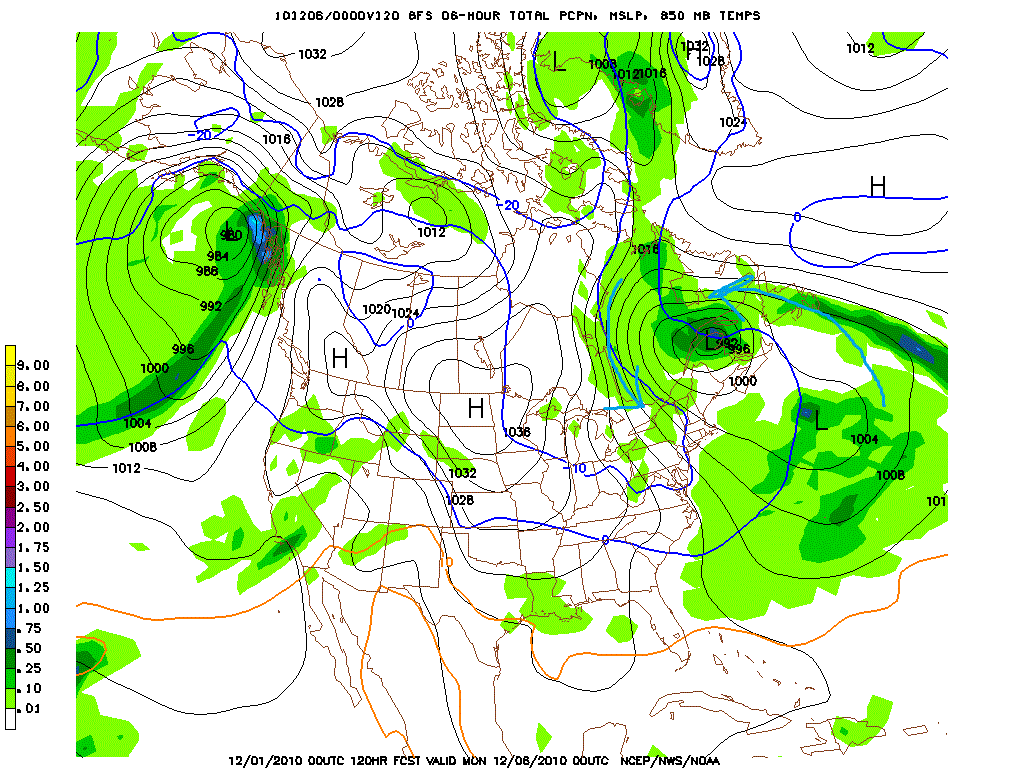
In the series of model image captures below you can clearly see the development and persistence of this system. Before we turn to them let me explain. The leading cold front will span a low pressure system that will rotate northwestward into Canada. The front will remain in place and a second wave of low pressure will develop and take a similar path. As it does it will reinforce the stalling first low. At the same time a high pressure system over Greenland will slide to the east allowing these stationary lows to swell in size and influence. The system of surface lows developing and sliding into the stalled low will repeat several times. This will all work to lock in a moist cyclonic flow over the North Country. I’ve drawn some arrows to help illustrate the motion and the flow patterns:
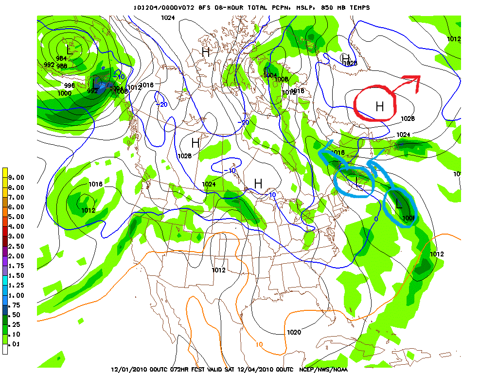
Now you can see the High moving to the east and the second low sliding into to the first.
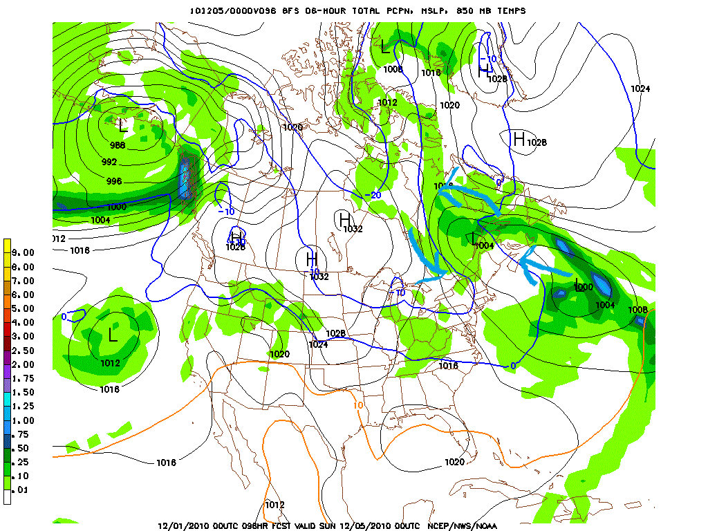
The high is out of the picture and we have a large complex stationary low.
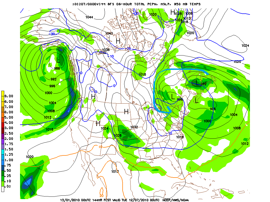
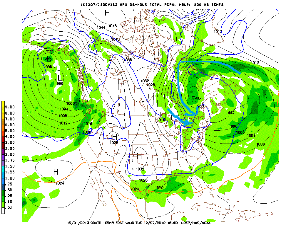
Not until the latter half of next week does the system begin to weaken and pieces break off towards the east.
This pattern certainly favors upslope snow across the Greens and ADK. A few extremely important ( and positive) things to note. First temps at the 850MB level look to be around -10c which is great for dendrite growth of snowflakes during upslope periods. Secondly, low level RH values look VERY high throughout the period:
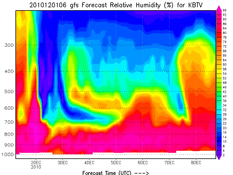
This is important to get any uplifted air to precipitate snow. If it ain’t near saturation at lower levels it will not need to lose moisture as it cools during ascent.
Lastly the models are strongly hinting at some lower level UVV (seen via Omega) during the latter part of this period. For models to be picking up on the lower level vertical motion this soon is a good sign.
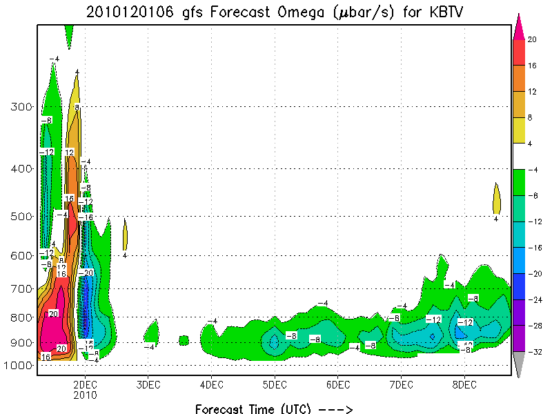
Clearly the computers agree that an upslope event is within reason. Yay. Now it’s far too soon to tell what accums are in order but if these past experiences tell us anything, its prob. going to be better than rain.
UPDATE UPDATE UPDATE
I think the signals keep getting stronger that a significant and prolonged upslope snow event will affect Northern VT. beginning this weekend and running until next weekend, northern VT – Jay, Manny, Smuggs and whatever else is up there will see periods of steady and sustained snow showers. Above 2500/3000 ft the total weekly accums will put some really big smiles on your faces. Something in the 12-24 inch range is certainly possible. We have to watch how this develops because these events are finicky but it sure seems to all be coming together.
Now one odd area to forecast will be the ADK. Model output isn’t too bullish on total QPF for this region however its going to be hard for parts of the High Peaks to not get into the action. With retrograding storms, parked upper level lows and a constant stream of lake effect from Ontario heading towards the NE I don’t see how the High Peaks don’t see periods of very nice snowfall.
You know what else is better than rain? The 2011 FIS Wall Calendar:


18 Comments
|
|||
| Home |

-
Search
New Comments
macbook repair seattle said: “macbook repair seattle Let’s get it started...(read more)” about Let’s get it started
Greg said: “Thanks for all this great info. And...(read more)” about Skiing Mt. Colden’s Trap Dike
Greg said: “Definitely late, but always welcome!” about Skiing Mt. Colden’s Trap Dike
Bob said: “[* Shield Security plugin marked this comment...(read more)” about Skiing Mt. Colden’s Trap Dike
Regular paint Maintenance said: “Regular paint Maintenance Behind The Schuss(ic) :...(read more)” about Behind The Schuss(ic)
The 2012-13 Ski Season in Photos #13 | NY Ski Blog said: “[…] tweeting about big Memorial Day snow...(read more)” about pow
ml242 said: “LuckyLuc and MadPat on the same day?...(read more)” about Deep Cover Anthropology
Talbert said: “Long time no comment..... But great to...(read more)” about Man of Many Moods
Twitter Feed
-
Categories
- Skiing (438)
- Weather (188)
- WTF (5)
- Quick Update (173)
- Full Trip Report (165)
- WebiGNARs (45)
- General Interest (38)
- Site News (27)
- Summer (59)
- Hiking (26)
- Swimming (15)
- Climbing (13)
- Longboarding (3)
- Whitewater Kayaking (2)
- Mountain Biking (1)
- SPA (16)
- Gear Review (8)
-
Archive
- October 2018
- June 2017
- November 2016
- October 2016
- March 2016
- January 2016
- October 2015
- February 2015
- January 2015
- December 2014
- November 2014
- October 2014
- September 2014
- July 2014
- April 2014
- March 2014
- February 2014
- January 2014
- December 2013
- November 2013
- October 2013
- September 2013
- August 2013
- June 2013
- May 2013
- April 2013
- March 2013
- February 2013
- January 2013
- December 2012
- November 2012
- October 2012
- September 2012
- August 2012
- July 2012
- June 2012
- May 2012
- April 2012
- March 2012
- February 2012
- January 2012
- December 2011
- November 2011
- October 2011
- September 2011
- August 2011
- July 2011
- June 2011
- May 2011
- April 2011
- March 2011
- February 2011
- January 2011
- December 2010
- November 2010
- October 2010
- September 2010
- August 2010
- July 2010
- June 2010
- May 2010
- April 2010
- March 2010
- February 2010
- January 2010
- December 2009
- November 2009
- October 2009
- September 2009
- August 2009
- July 2009
- June 2009
- April 2009
- March 2009
- February 2009
- January 2009
- December 2008
- November 2008
- October 2008
- April 2008
- March 2008
- February 2008
-
Friends of F.I.S.

About Us:
We are a group of powder hungry, east-coast-bred, world-traveling skiers and riders who Earn Our Turns to bring you the best stoke a click-of-the-mouse can buy.We hope our adventures inspire you to Earn Your Turns as well!
LEARN MORE

Latest Weather
When one makes meatballs, one must begin with quality meats: ...
Read more in: Meatballs! (read more)
Ben
wrote on December 1st, 2010 at 11:31 amYES!
finally some good news!
Tylerjames
wrote on December 1st, 2010 at 12:01 pmSweet, thanks for the update.
jumpin jimmy
wrote on December 1st, 2010 at 1:25 pmI saw a post on ski vt that it is snowing in upstate NY right now…changing over
Porter Haney
wrote on December 1st, 2010 at 6:47 pmSo what happened? Did you fix your pants at lunchtime?
Anonymous
wrote on December 2nd, 2010 at 9:21 amI stuck it out. We have a business casual dress code.
Anonymous
wrote on December 1st, 2010 at 6:55 pmThey are calling for 25 cms of snow tommorow for Charlevoix. Maybe more in the mountains.
Anonymous
wrote on December 2nd, 2010 at 9:22 amNew Rule: Canadian posters pls include a map and or GPS coords. for your mountains. I know where Montreal and St. Caherines, Ont. are and that’s about it.
colin_extreme
wrote on December 2nd, 2010 at 11:56 amhttp://lmgtfy.com/?q=charlevoix+quebec
by the way, latest 84H nam looking very bullish..
LH: How accurate is the formula used to compute snow depth from liquid?
http://wxcaster.com/gis-snow-overlays.php3?STATIONID=CXX
Lionel Hutz
wrote on December 2nd, 2010 at 4:37 pmColin:
A) That’s the NAM so you really have to watch it beyond 60 hours. It’s a gridded model so the ability for it to compute data for thousands of grid points overwhelms the system at about 60 hours. It’s great for short term cyclogenesis however.
B) NEVER trust model output for total snowfall. Heck- barely trust model output for total QPF. Total snowfall is something that is far too complicated for models to really get handle on.
Regardless…stay tuned because I think you are going to be very happy by next weekend.
Damon
wrote on December 1st, 2010 at 7:28 pm2 or so inches in Sarananc lake and 3 or so in Tupper Lake as of 7pm
powhounddd
wrote on December 1st, 2010 at 8:23 pmheck yes!
I <3 magic snow. Very good. Good indeed. Must…wait….
bushman
wrote on December 2nd, 2010 at 8:43 ampants, smants. I’ll take orogrphahic, even nonrogrpahic, snow anytime to compensate for that langwinded yarn about pants bursting from too many chilly dogs. Hello? Afraid to tell ya better cut down, start hiking like the rest of us, LH, so you too will be able see AND buckle your boots. pants getting caught is right up there with dog eating homework….. heading to JP for some turns tomorrow night–hopefully the j clouds hovers all weekend. thanks for the report.
arewolfe
wrote on December 2nd, 2010 at 7:47 pmf*****g tits yes. finally. to at least get a base going would be fantastical.
Greg
wrote on December 3rd, 2010 at 9:34 amsorry for the censure Rob. Nothing personal. I *try* to keep FIS completely SFW…
bushman
wrote on December 3rd, 2010 at 8:10 amthis morning’s report says 2-4 today with more tomorrow…sore throat coming on boss…see ya (hey AW:keep the comments clean, huh? I’m having breakfast when I read this site and dont wanna read stuff out of line-thanks)
bushman
wrote on December 4th, 2010 at 7:41 amat 7:00 AM flurries; at 7:30 snowing hard @ JPeak, blowing hard though. calling for snow squalls all day; maybe 2-4; NWS put out winter warning for tonight 4-8; fifure it’ll do this all day and J will get a foot or so. J cloud thank you.
Ben
wrote on December 4th, 2010 at 9:05 amthanks for the update!!!
don’t forget to tweet @fiswx or text fisweather@gmail.com with weather/conditions updates for the FISWX feed!