
Welcome back to the Summer Series Weekend Outlook. Hopefully you all had a good memorial day and are getting geeked up for summer. I know I am. Now without too much beating around the bush lets get to the forecast for this weekend.
| Jump to: | Synopsis | Friday | Saturday | Sunday | Extended |
SYNOPSIS:
As will be the case with many summer weekends, this weekend will feature a wide cross section of weather. There will be swings from Sunny and Warm, to rainy and humid, to cool and “mountainy” (What- that’s not a real word? Well it is here. In my world it refers to those days often experienced in the Northeastern mountains in the summer. Cool-ish, breezy, with broken clouds, some sun and a passing shower at times….that’s “mountainy”)
Overall the best day looks to be Friday as a departing low pressure clears with the building in of a weak surface high.
A low on Saturday will travel along the NY/Can border and push the surface high out. Rain associated with this system will overspread the North Country with the heaviest amounts being found along the Green spine, ADK and NH mountains, though by the afternoon the rain should be only spotty in nature. Chances for Thunderstorms will be confined to the S/E portions of the Northeast on Saturday as the cold front from the system drives into some rather humid and unstable air. With moderate CAPE values I could see some gusty boomers develop during the day.
“Mountainy” weather will arrive on Sunday as a broad trough works into the region. Stray showers with sun (I know…what a crappy way to describe a day) will prevail in the North, while a disturbance works across the PA/NY border. A pocket of moderate storms or heavy showers could develop with this disturbance. Models have overdone the extent of precip with this system but we’ll address that later.
| Jump to: | Synopsis | Friday | Saturday | Sunday | Extended |
FRIDAY:
Primary Concerns: Lingering low level clouds and showers in the morning
Best Location: The entire north country looks to have a great Friday. Only a few pockets of low clouds, stuck to the highest terrain should remain as a concern.
Best Activity: Really anything. Get out and enjoy.
Recreational Forecast:
By Friday morning, any remnants from tonight’s weather will be pushing out east past Maine. A few lingering showers can’t be ruled out as we head into the morning as pockets of instability will remain. However as we head into the afternoon hours, all of the weather should break up and skies should clear.
With plenty of sunshine, temps should rise to above seasonal norms. Upper 7os for the ADK, Greens and NH is within reason. 80s for the Catskills and Berks seems similarly within reach.
With moderate dewpoints
Friday afternoon should feel just peachy. So get out there.
| Jump to: | Synopsis | Friday | Saturday | Sunday | Extended |
SATURDAY:
Primary Concern:
There are two areas of concern on Friday. First and most widespread will be rain associated with a system working just north of the NY border. This system it’s associated cold front should bring some moderate rain through the early part of Saturday to the ADK, Greens, and Whites. The Catskills might miss the steadiest precip but then might be under the gun for risk two… some mixed T-storms firing up in the afternoon.
As the front pushes into some relatively wet and unstable air, there exists a decent risk for gusty thunderstorms across the southern tier of NY, Eastern PA and NJ.
SPC has a good area outlined.
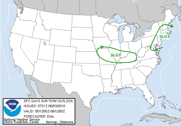
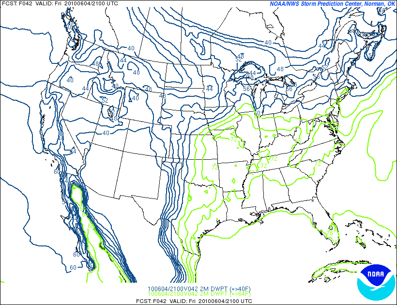
Though I’d warp this image slightly and prob. pull it out of VT, extend it up the Hudson valley a little further north and take out out So. NH. based on the dewpoints:
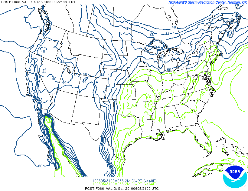
But regardless – you get the idea.
Best Areas:
Tough call for Saturday. Areas north will see the steadiest rain in the morning while areas to the south have the greatest risk for thunderstorms in the afternoon. The Pocanos might be a nice call as they seem just south enough to avoid the steady rain and west enough to stay out of the highest T-storm danger. The Catskills could similarly split the difference.
Best Activity:
Saturday isn’t a gem but by the afternoon if you want to get outdoors you can. Given the low clouds and stead-ish morning rains I’d look away from the mountains and maybe steer to the lakes. Might be a good day for some paddling in the afternoon in the north country or maybe a nice afternoon bike ride as the system will turn the flow to the NW and knock the dewpoints down quite a bit.
Further south- prob. just watch out for the t-storms and pack an shell in case the morning showers are more widespread.
RECREATIONAL FORECAST:
As Friday’s surface high moves out, a weak area of low pressure will move in from the great lakes.
With a warm front pushed ahead and a tailing surface trough
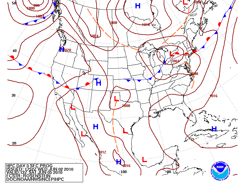
this is a classic summer system that will bring precip to the north country and t-storms to the southern Northeast.
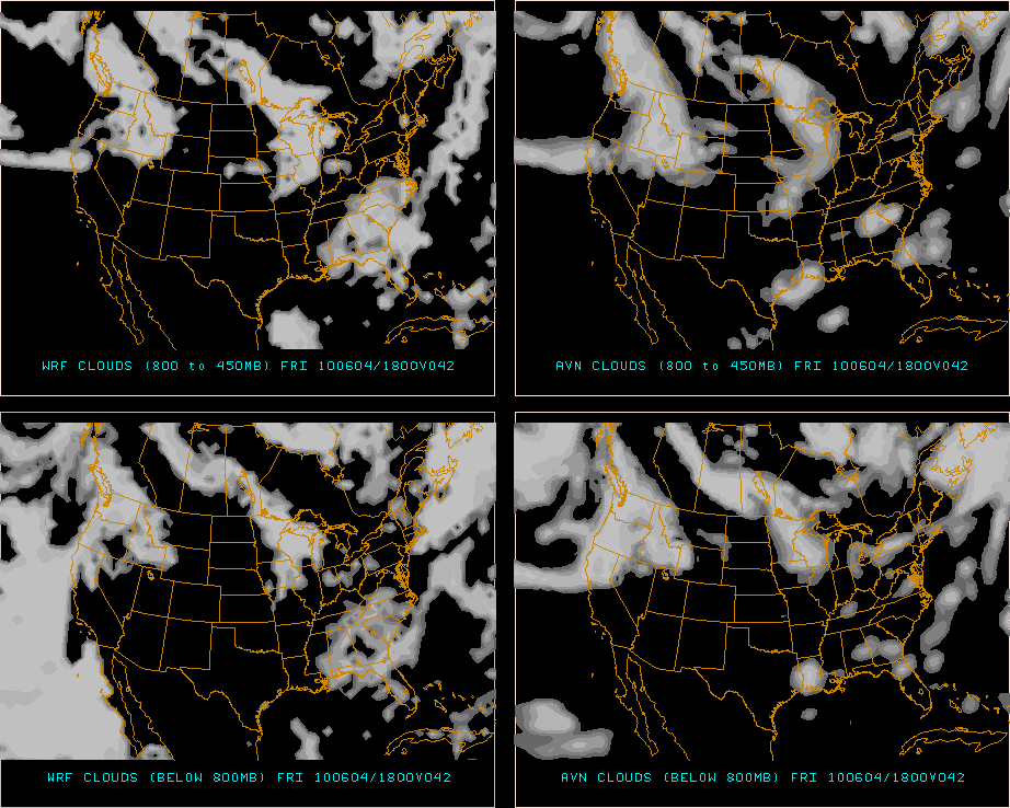
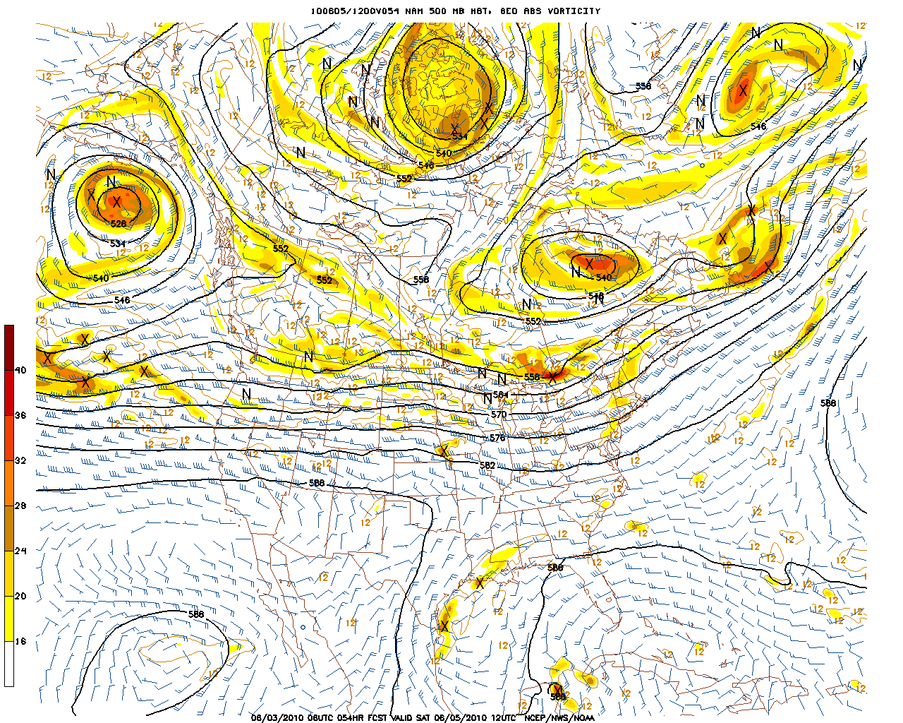
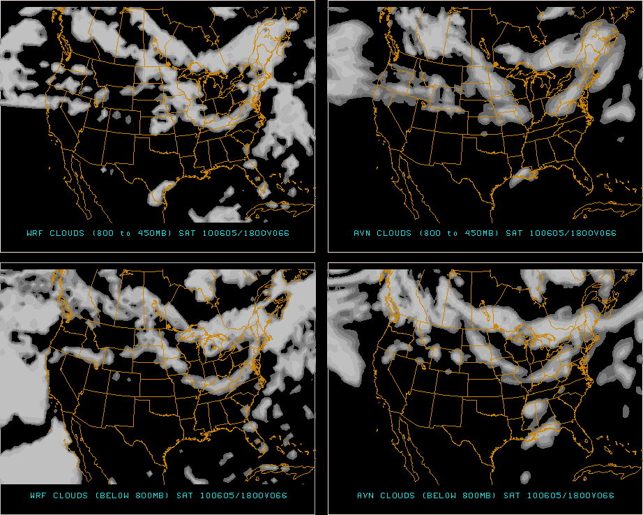
By Saturday morning, the NAM (which is a little faster than the other models) shows a solid does or precip over the ADK and Greens.
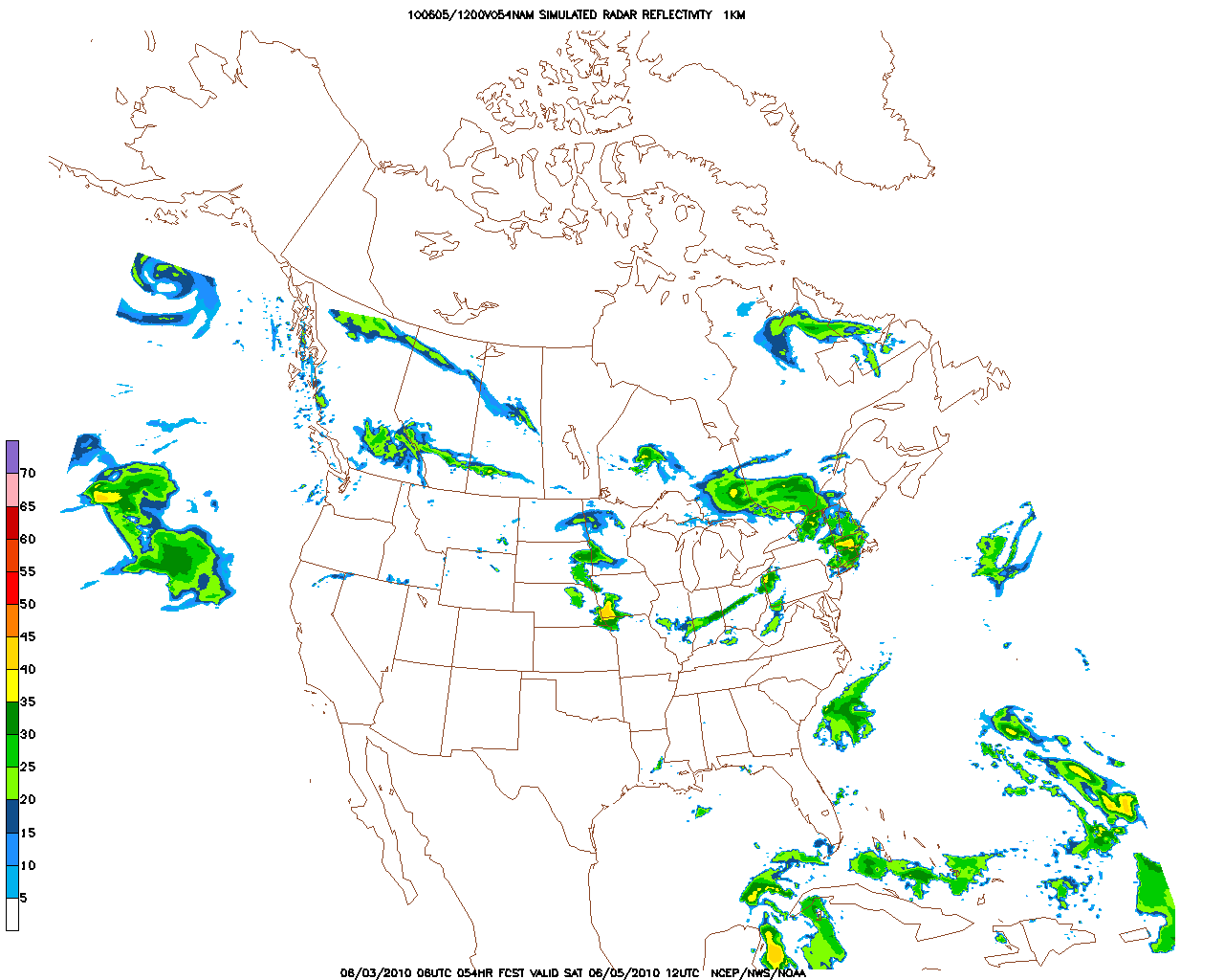
By the afternoon on Saturday however, much of the steady precip should be over for the north country. An unstable west/north west flow will prevail and with pockets of vorticity stray showers can’t be ruled out. A breaking up of the clouds will even be possible.
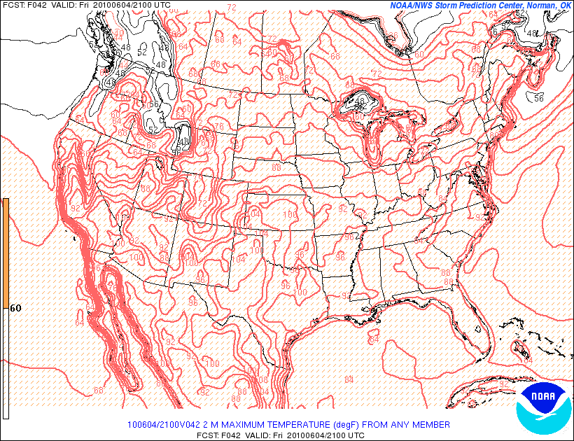
With temps only reaching into the lower 70s for the North Country and upper 70s for the Catskills if the sun doesn’t come out, Saturday could feel noticeably cooler. Esp. in the afternoon as the NW flow brings some cooler dry air into the region.
| Jump to: | Synopsis | Friday | Saturday | Sunday | Extended |
SUNDAY:
UPDATE:
Going to try to put a friday afternoon update whenever I can. Most of the time it will focus on Sunday as the high res. models covering sunday just start to come in on friday afternoon.
As it is, this weekend Sunday is trending wetter for the North Country.
Primary Concern:
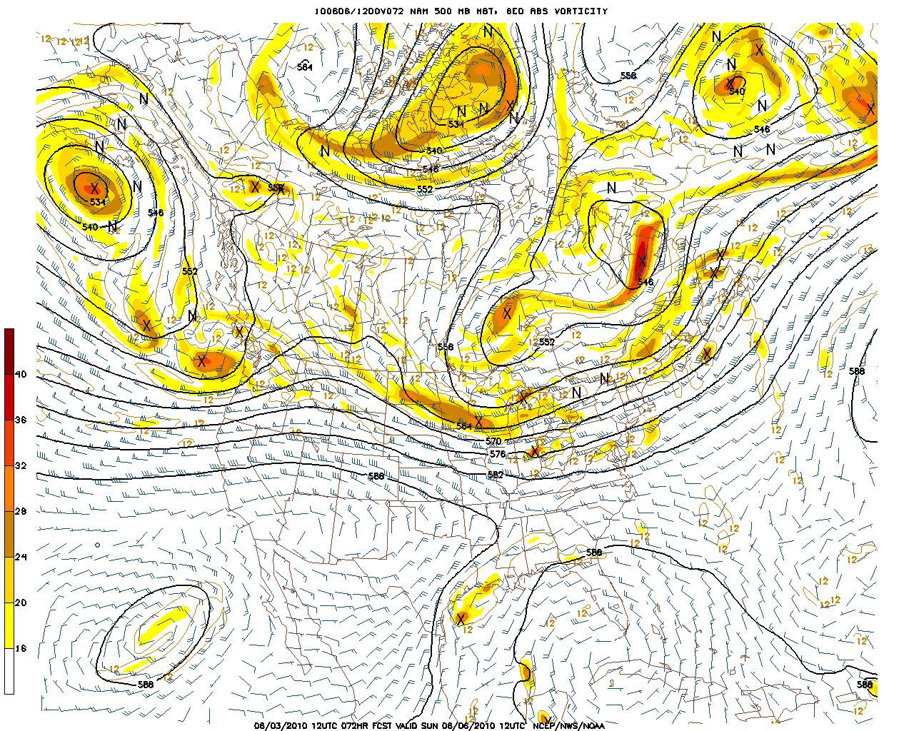
Development of a strong system working into the PA/NY border. Embedded T-storms and periods of heavier rain. Models have been expanding on this threat in the last few days and the trend has to be noted.
As per the general update- as of friday afternoon it is starting to look like the low’s effect will be more widespread and generally bring another dose of rain into the North Country on Sunday.
Best Areas:
Old fxt was for areas north of albany. Gotta reverse that as this system looks more widespread. At this time all locations look similary wet. While there is still the chance the upper level low shunts the precip to the south, that is looking increasingly unlikely. Of course this means that the chances are raised that areas in PA and NJ – esp southern PA and NJ would miss out on the rains.
Best Activity:
Given the potential for rain I’m not sure what the best activity would be. Kayaking could be good as rain on saturday and sunday could get the flow rate up. Perhaps fishing? I know those smallmouths get pretty hungry when it rains.
RECREATIONAL FORECAST:
By Sunday morning, the clearing Saturday system will have pushed a broad upper level low and surface high into the North Country.
Along the southern edge, a system will develop over the great lakes
However, now it looks like this system will move N/E into NY and spread a large batch of precip into the North Country. Sorry for the complete flip flop here but you gotta play the trend here! I’d say that as the system moves n/e it will push steady precip in to the ADK and Green mountains with broken precip further south. By the afternoon precip will be spotty in the catskills with sun and some humid warm air working in. A surface trough will push through late in the day in conjunction with the system. Rising instability paramaters certainly indicate the potential for t-storm develop in the afternoon along with showers and small rain squalls.
| Jump to: | Synopsis | Friday | Saturday | Sunday | Extended |
Extended outlook
Once the Sunday system gets out of the way late Sunday afternoon, skies should clear for Monday. Temps should be cool. Down south- 70s. Up north 60’s to 70.

4 Comments
|
|||
| Home |

-
Search
New Comments
macbook repair seattle said: “macbook repair seattle Let’s get it started...(read more)” about Let’s get it started
Greg said: “Thanks for all this great info. And...(read more)” about Skiing Mt. Colden’s Trap Dike
Greg said: “Definitely late, but always welcome!” about Skiing Mt. Colden’s Trap Dike
Bob said: “[* Shield Security plugin marked this comment...(read more)” about Skiing Mt. Colden’s Trap Dike
Regular paint Maintenance said: “Regular paint Maintenance Behind The Schuss(ic) :...(read more)” about Behind The Schuss(ic)
The 2012-13 Ski Season in Photos #13 | NY Ski Blog said: “[…] tweeting about big Memorial Day snow...(read more)” about pow
ml242 said: “LuckyLuc and MadPat on the same day?...(read more)” about Deep Cover Anthropology
Talbert said: “Long time no comment..... But great to...(read more)” about Man of Many Moods
Twitter Feed
-
Categories
- Skiing (438)
- Weather (188)
- WTF (5)
- Quick Update (173)
- Full Trip Report (165)
- WebiGNARs (45)
- General Interest (38)
- Site News (27)
- Summer (59)
- Hiking (26)
- Swimming (15)
- Climbing (13)
- Longboarding (3)
- Whitewater Kayaking (2)
- Mountain Biking (1)
- SPA (16)
- Gear Review (8)
-
Archive
- October 2018
- June 2017
- November 2016
- October 2016
- March 2016
- January 2016
- October 2015
- February 2015
- January 2015
- December 2014
- November 2014
- October 2014
- September 2014
- July 2014
- April 2014
- March 2014
- February 2014
- January 2014
- December 2013
- November 2013
- October 2013
- September 2013
- August 2013
- June 2013
- May 2013
- April 2013
- March 2013
- February 2013
- January 2013
- December 2012
- November 2012
- October 2012
- September 2012
- August 2012
- July 2012
- June 2012
- May 2012
- April 2012
- March 2012
- February 2012
- January 2012
- December 2011
- November 2011
- October 2011
- September 2011
- August 2011
- July 2011
- June 2011
- May 2011
- April 2011
- March 2011
- February 2011
- January 2011
- December 2010
- November 2010
- October 2010
- September 2010
- August 2010
- July 2010
- June 2010
- May 2010
- April 2010
- March 2010
- February 2010
- January 2010
- December 2009
- November 2009
- October 2009
- September 2009
- August 2009
- July 2009
- June 2009
- April 2009
- March 2009
- February 2009
- January 2009
- December 2008
- November 2008
- October 2008
- April 2008
- March 2008
- February 2008
-
Friends of F.I.S.

About Us:
We are a group of powder hungry, east-coast-bred, world-traveling skiers and riders who Earn Our Turns to bring you the best stoke a click-of-the-mouse can buy.We hope our adventures inspire you to Earn Your Turns as well!
LEARN MORE

Latest Weather
When one makes meatballs, one must begin with quality meats: ...
Read more in: Meatballs! (read more)
powhounddd
wrote on June 4th, 2010 at 8:22 amThanks a bunch LH, youda man!
‘Mountainy’ – darn straight! Finally! Let’s get that one to Webster’s via viral internet usage. I for one have just elected it into the living language that is English and will honour(!) it by using it from now on.
K_C
wrote on June 4th, 2010 at 9:55 amThanks for the info LH! looks like our hiking day will be Sunday, the mountainy day, although trails are prob going to be nice and muddy for us.
Porter Haney
wrote on June 4th, 2010 at 11:42 amMountainy. I dig that. Hope we get some of that in Utah. Headed out to a place thats flat and salty. Will need it to dry out to reach top speed.
Anonymous
wrote on June 6th, 2010 at 10:38 amjust thought i’d chime in and offer a vote of confidence in this forecast. we went ahead and booked up saturday late morning to late evening with outdoor activies figuring sunday would be a soaker… and boy i’m glad we did! worked out perfectly as now we’re tired and sore after plenty of mileage and cold/refreshing swimming holes on saturday, watching the sunday rain… THANK YOU LIONEL!