
“Lionel, you mean Superbowl right?”
No. I don’t. As many of you know I was raised in and around the great (shut up) city of Philadelphia. Twenty-two years ago, in light of the fact that the Philadelphia Eagles would never be in a Super Bowl (or win said Superbowl) and because Philadelphia loves food, the local sports radio station created this little event where fat dudes would eat chicken wings for prizes the friday before the superbowl. They called it “the Wingbowl.” To trump it up they got some local strippers to count the wings that were eaten. It was a gag. It was held in a hotel lobby.
One problem…we loved it. Seriously. What was a gag is now the richest eating competition in the world. It is now held in the hockey stadium where 20,000 tickets sell out in under two hours. More beer is sold during the wingbowl (it’s from 6 to 9 am..doors open at 4:30, beer at 5) than ANY other event at the stadium including concerts. There is procession of “eaters” with floats and a many thousand dollar prize for the best entrance. There are dozens of mostly naked women (wingettes [careful now]) who count wings for their “eaters” and then cavort around and ride a mechanical bull two win a car (or harley). The winning eater not only gets a car but also and a huge diamond ring (like a superbowl ring), and something around twenty thousand dollars cash. To give you a sense of magnitude the record number of chicken wings eaten in 3o minutes is 337 by Kobayashi. The doctor for event..A VET. And there is only one rule, “you heave, you leave.”
#Philly.
Anyway, as you have all decided I’m a sick animal and Philly is a gross place that needs to burn, I’ll turn to the weather for Wingbowl weekend.
Currently, a weak ridge of high pressure is building over the north country. That ridge of high pressure will slide east Saturday as a low pressure systems moves northeast off to our west. You can see the low in the map below.
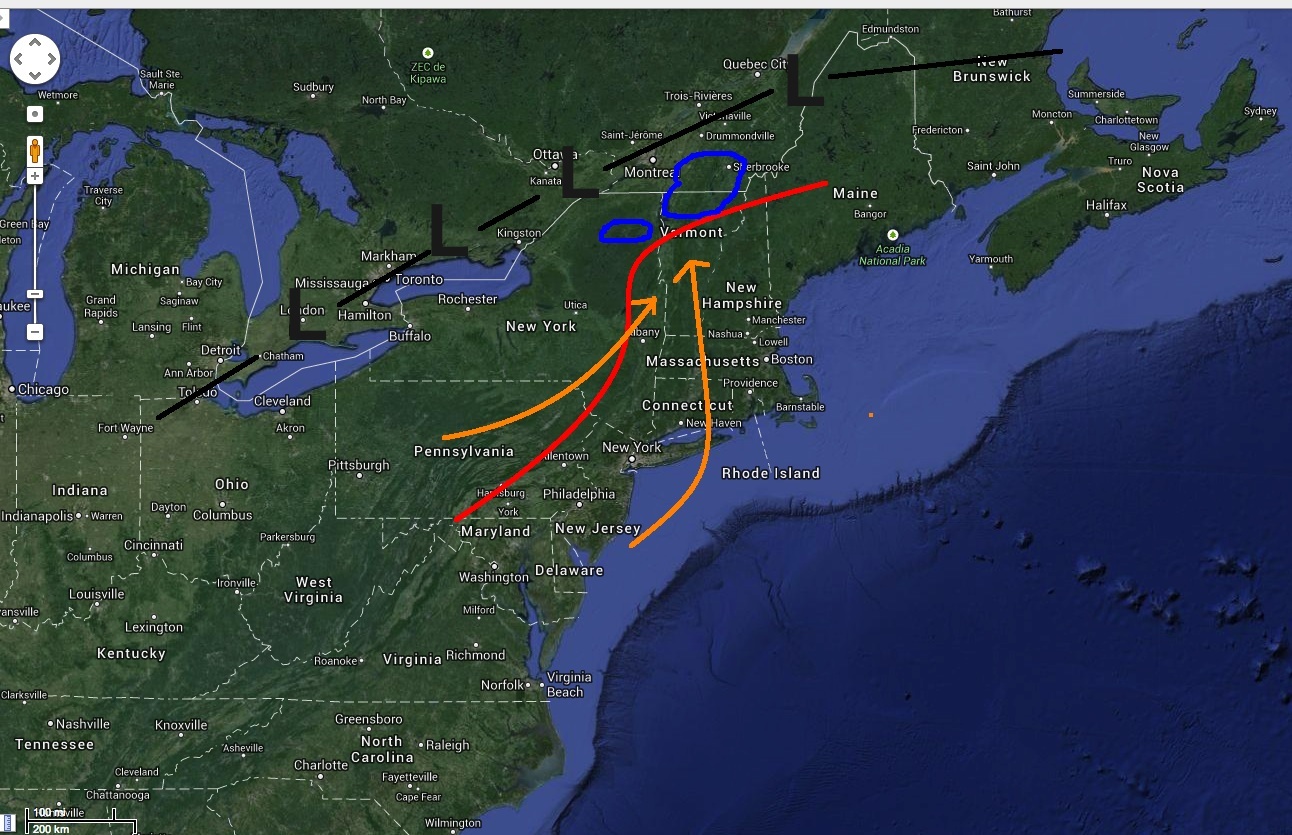
As the low moves north it will push warm air in from the southwest. This warm air advection will push 850mb temps to just about 0c overnight sunday as the precip moves in. I’ve marked in red the consensus extent of the 850mb freezing line. Looks like temps north and west of this line will just stay below 0C — meaning snow. As the warm air moves into the region it will lift and we’ll see some periods of snow just north of the warm front. Looks like right now areas circled in blue on the map will see the best snows. By sunday AM (storm snow moves in from early saturday evening through sunday am) I think these areas will see a general 4-6″ snowfall.
One notable development on the high res models is the potential for heavier snow in the High Peaks.
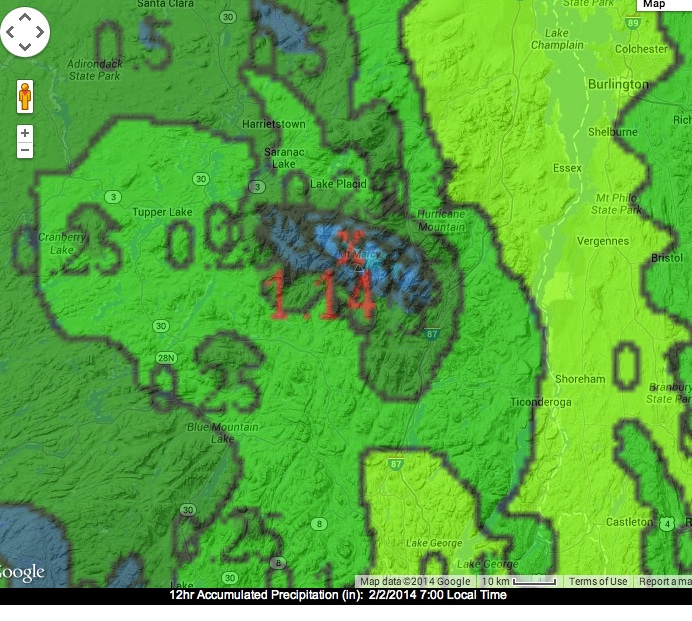
Traditionally, events like this which have a period of precip with south west winds (marked in orange) produce a fair amount of snow in the High Peaks as the HP have a pretty strong orographic profile as approached from the S/W. I’m not sure I see 1.14 inches of water (12″ of snow) but it’s certainly possible that the ADK has the best N/E snow. Oh and don’t sleep on areas north of Jay…like Sutton. The best dynamics for snow (temp and lift) are likely to occur just north of the border. Thus I think Sutton could see maybe 6-10″.
Looking forward there is a lot of talk about a storm midweek next week. Models are certainly fairly consistent that something is going to eject out of the midwest and slide generally east across the country. On the edge of GFS reasonability it certainly looks like a wet 24 hours.
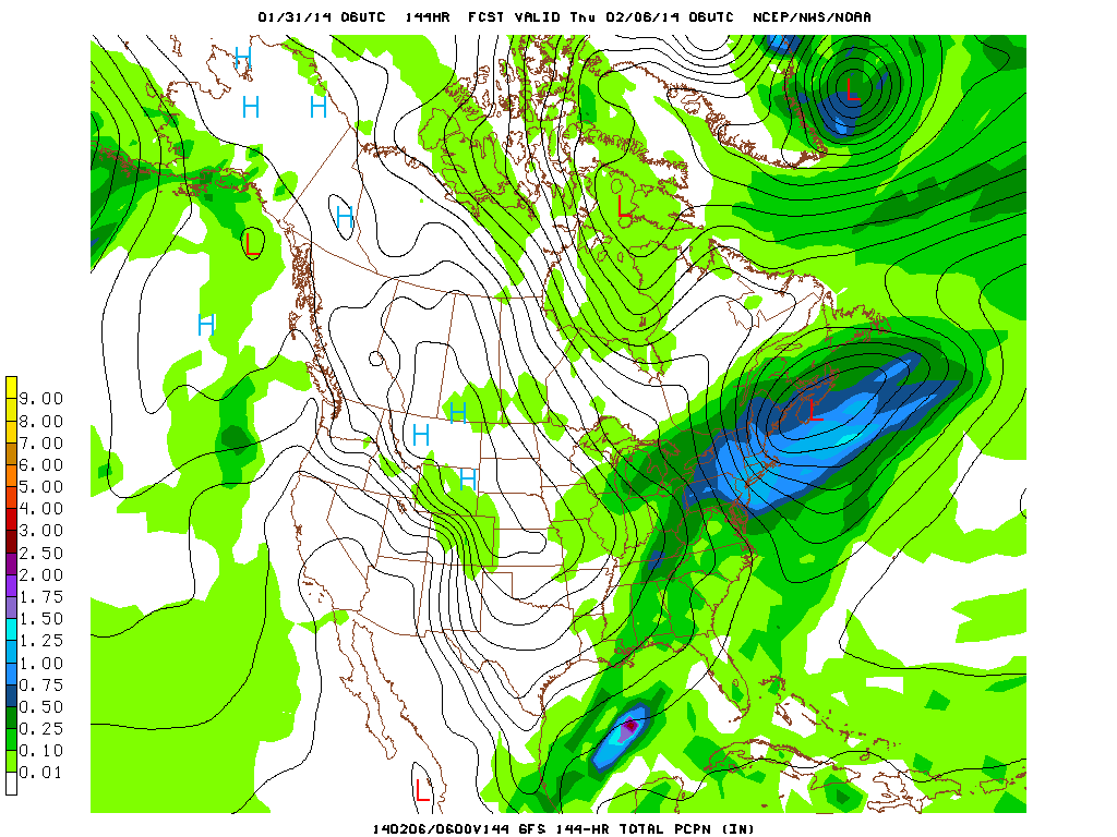
Problem is I don’t buy that this is a real snow maker for the North Country. The upper level pattern is fairly flat. For lows to track into the deep N/E Mtns and wrap-up into strong snow makers the upper level should feature a fairly deep trough with a slightly negative tilt (trough axis aligns NW/SE). That shape causes low pressure systems to track N/W into the center of New England. As you can see below the trough shape isn’t that. It’s flat.
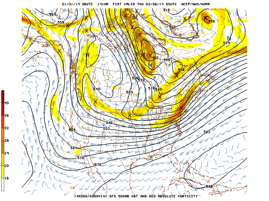
In my mind, this makes it more likely for the low to slide off to our south and east. Not to say that we are unlikely to see 3-6″ …just that it is unlikely we’re talking about a 1-2′ nor’easter out of this event. Of course I could be wrong and the low tracks right through central NY and So. VT and we’re just crushed. I’ll keep you updated.
UPDATE…No need to change my forecast. Storm will track south of our region tonight through tomorrow. Heaviest snow will be in a band crom Northern Mass through southern VT. Heaviest snow totals will be at Killington where 8-12 inches of snow could fall. The Catskills will also do well and could see 8-12 inches of snow.

3 Comments
|
|||
| Home |

-
Search
New Comments
macbook repair seattle said: “macbook repair seattle Let’s get it started...(read more)” about Let’s get it started
Greg said: “Thanks for all this great info. And...(read more)” about Skiing Mt. Colden’s Trap Dike
Greg said: “Definitely late, but always welcome!” about Skiing Mt. Colden’s Trap Dike
Bob said: “[* Shield Security plugin marked this comment...(read more)” about Skiing Mt. Colden’s Trap Dike
Regular paint Maintenance said: “Regular paint Maintenance Behind The Schuss(ic) :...(read more)” about Behind The Schuss(ic)
The 2012-13 Ski Season in Photos #13 | NY Ski Blog said: “[…] tweeting about big Memorial Day snow...(read more)” about pow
ml242 said: “LuckyLuc and MadPat on the same day?...(read more)” about Deep Cover Anthropology
Talbert said: “Long time no comment..... But great to...(read more)” about Man of Many Moods
Twitter Feed
-
Categories
- Skiing (438)
- Weather (188)
- WTF (5)
- Quick Update (173)
- Full Trip Report (165)
- WebiGNARs (45)
- General Interest (38)
- Site News (27)
- Summer (59)
- Hiking (26)
- Swimming (15)
- Climbing (13)
- Longboarding (3)
- Whitewater Kayaking (2)
- Mountain Biking (1)
- SPA (16)
- Gear Review (8)
-
Archive
- October 2018
- June 2017
- November 2016
- October 2016
- March 2016
- January 2016
- October 2015
- February 2015
- January 2015
- December 2014
- November 2014
- October 2014
- September 2014
- July 2014
- April 2014
- March 2014
- February 2014
- January 2014
- December 2013
- November 2013
- October 2013
- September 2013
- August 2013
- June 2013
- May 2013
- April 2013
- March 2013
- February 2013
- January 2013
- December 2012
- November 2012
- October 2012
- September 2012
- August 2012
- July 2012
- June 2012
- May 2012
- April 2012
- March 2012
- February 2012
- January 2012
- December 2011
- November 2011
- October 2011
- September 2011
- August 2011
- July 2011
- June 2011
- May 2011
- April 2011
- March 2011
- February 2011
- January 2011
- December 2010
- November 2010
- October 2010
- September 2010
- August 2010
- July 2010
- June 2010
- May 2010
- April 2010
- March 2010
- February 2010
- January 2010
- December 2009
- November 2009
- October 2009
- September 2009
- August 2009
- July 2009
- June 2009
- April 2009
- March 2009
- February 2009
- January 2009
- December 2008
- November 2008
- October 2008
- April 2008
- March 2008
- February 2008
-
Friends of F.I.S.

About Us:
We are a group of powder hungry, east-coast-bred, world-traveling skiers and riders who Earn Our Turns to bring you the best stoke a click-of-the-mouse can buy.We hope our adventures inspire you to Earn Your Turns as well!
LEARN MORE

Latest Weather
When one makes meatballs, one must begin with quality meats: ...
Read more in: Meatballs! (read more)
Sea Cay
wrote on January 31st, 2014 at 11:38 amDon’t know which makes me feel worse: the thought of eating 337 wings (in any amount of time) or more crappy winter weather! At least it has been cold enough to hold what snow there is on the ground. It may be time to make a sacrifice to Ullr to bring some real snow. I’ve got some old straight sticks that are perfect for a bonfire!
sjs
wrote on January 31st, 2014 at 12:28 pmdamn. mad/bush right on the line.
cat in january
wrote on February 3rd, 2014 at 7:29 pmSo, your call from 1/31 looks pretty good in hindsight. What are you calling now that it is 2 days away?