Weather Blather: Presidents/Valentines Day Weekend Weather
With this all important three day weekend looming we should prob. have a little chat about the weather on the slopes (boy that sounded lame. -1 man point).
This weekend will feature rather quiet weather in Ski Country. Not that conditions will be bad. In fact they could be quite nice.
Overall we’ll see snow showers on and off throughout the weekend. Most notably the snow showers will be heaviest along the spine of the green mountains. (Shocker).
Right now the exiting surface low is pulling winds out of Canada with an almost direct northerly flow. This is favoring WV where up to a foot of snow is possible by the end of the next 48 hours. Steadily however the flow will turn more NW. This should allow for the all important cross barrier flow in the Greens and enhance the natural snow showers.
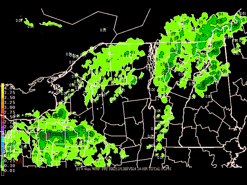
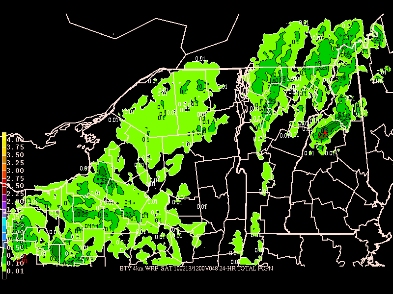
The HIRES WRF picks this up pretty well.
24hr precip thru Friday AM:

The beat goes into Sat:

Looking at this map, and the climo factors at play, I’d say that a steady 1-2 inches should be expected per day over the weekend. There might be some heavier showers over in NH as we get interaction with the surface low. Maybe the MTW area gets 4-5 late friday into sat. We’ll see. So overall, while this isn’t a ton of snow, it should at least keep surfaces fresh.
As for temps, we’re looking at highs in the low 20s with lows in the single digits. Winds could be gusty at times but when aren’t they in the winter in the N.E. mountains.
Looking into the future I sadly don’t see a ton of changes for the overall weather pattern through the end of next week. I knew this would be a blockbuster February and boy has it ever been for DC and Philly. I just never imagined that ALL the snow would be confined south of the NYS Thruway. I mean that’s a once in a hundred years phenomenon…you have to marvel at it!
7 Comments
Leave a Reply
|
|||
| Home |


Greg
wrote on February 11th, 2010 at 12:23 pmDUDE! Thanks for the update. I’ve been watching the GFS and the ECWF forecast alot of circulation laden with moisture coming out of the NW on the backside of snowmaggeddon II, and I’ve been trying to figure out if it stood a chance of making “magic snow” or not… sounds like it stands a chance.
What’s the difference between the forecast conditions coming up, and the ones that produced the mega-magic-snow ((C) G. Petrics) following the rain event?
Lionel Hutz
wrote on February 11th, 2010 at 12:27 pma) It was actually Snow-mageddon III down here.
b) The biggest difference I see is the direction of the flow and the RH values at lower levels of the atm. Now this doesn’t mean that we can’t kick up a real heavy shower here and there BUT the factors just don’t seem as aligned. I’d like to see the low a little more vertically stacked and broader slightly further west. I’d like a little more 700mb RH and lower 10m winds.
Michael
wrote on February 11th, 2010 at 1:38 pmLooking at the 8-14 day extended things look bleak. Both here in Vtah and over in Utah (where I’m headed, 2/20-27). Please give me a good wishcast for the extended!
Lionel Hutz
wrote on February 11th, 2010 at 1:44 pmFirst, throw out the 8-14 day forecast. It’s crap for the east coast.
Second I wouldn’t say things look bleak in VT. No rain in the forecast, nice midwinter temps and light snow day in day out. When it’s not snowing it should be sunny. Look powder is nice but you know what…skiing is fun and around here as long as we stay out of the rain/thaw/freeze cycle we shouldn’t be calling things bleak!
As for UT…look kids…it goes off sometimes and sometimes it doesn’t. Right now the pattern (typical for LCC/BCC in Nino’s) is for a ridge to persist for weeks at a time broken by deep intense long duration storms.
December had one (60 inch cycle). Jan had one (82 inch cylce). Feb could have one as we get towards the end of the month…we’ll see. If it does turn wetter out there I’d suspect it would be in the form of a more zonal pattern instead of the deep trough that existed in Jan.
Tom
wrote on February 11th, 2010 at 4:38 pmLH,
You rock!
We at Exotic and at my day job at Northern Ski Works in Ludlow, VT think your website is the bomb!
A few inches a day is a net gain!
We all travel to Jay and the bush and Stowe and MRG looking for untracked.
We always look to earn our turns and if something looks interesting,
We give it a go!
Keep up the good work!
And Invite me and my co workers on some of your “magic snow” powder shoots!
Thanks!
Tom
powhounddd
wrote on February 11th, 2010 at 6:48 pm“skiing is fun and around here as long as we stay out of the rain/thaw/freeze cycle we shouldn’t be calling things bleak!”
darn tootin. Thanks for the weather outlook, this weekend will be FUN to be in the mountains – get it while it’s good!
PS No killer earthquakes, famines, plagues and whatnot also add to the stoke, let’s count our blessings, eh?
Doremite
wrote on February 12th, 2010 at 9:16 am“skiing is fun and around here as long as we stay out of the rain/thaw/freeze cycle we shouldn’t be calling things bleak!”
Two times!