
And so it begins….a chance for some “flutter” this weekend. Updated 10/2
As you many have heard (and if you follow my tweets and those on FISWX you would know that there is a very decent chance this weekend of seeing some snow flakes. As an aside, we are going to coin a new term in this post: “Flutter.” (Yes I know it’s already a word). Flutter is what I’m going to use to describe snow flurries out of season that don’t add up up to much, maybe leave a coating here and there, and generally just stoke the fires. That’s flutter. Deal with it. Or not…I don’t care….it’s your loss. Read on….
Update…
Not sure we got where we were forcasted to go. DP stayed rather high last night and so the temp did as well. As a general rule when looking at night time lows the dew point serves as a good guide as temp rarely falls below the dewpoint. So not sure we are in the best shape for “flutter” this am. However….it is still possible for the next few hours. Sunday am doesn’t look as good to me. A system working in from the west should create some warm air advection ahead of it and bring some warmer air into the region.
Older:
As we enter the weekend an early season, northern stream trough will drop out of Canada into the Great Lakes. A few days ago this looked to settle squarely over the North Country…This would have bottomed out temps hard core, but all models have seemingly settled on this trough dropping into the west.
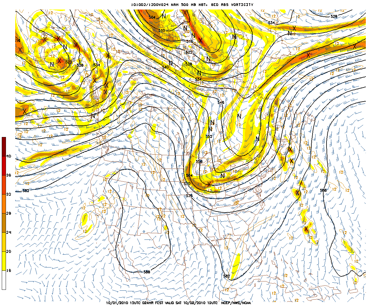
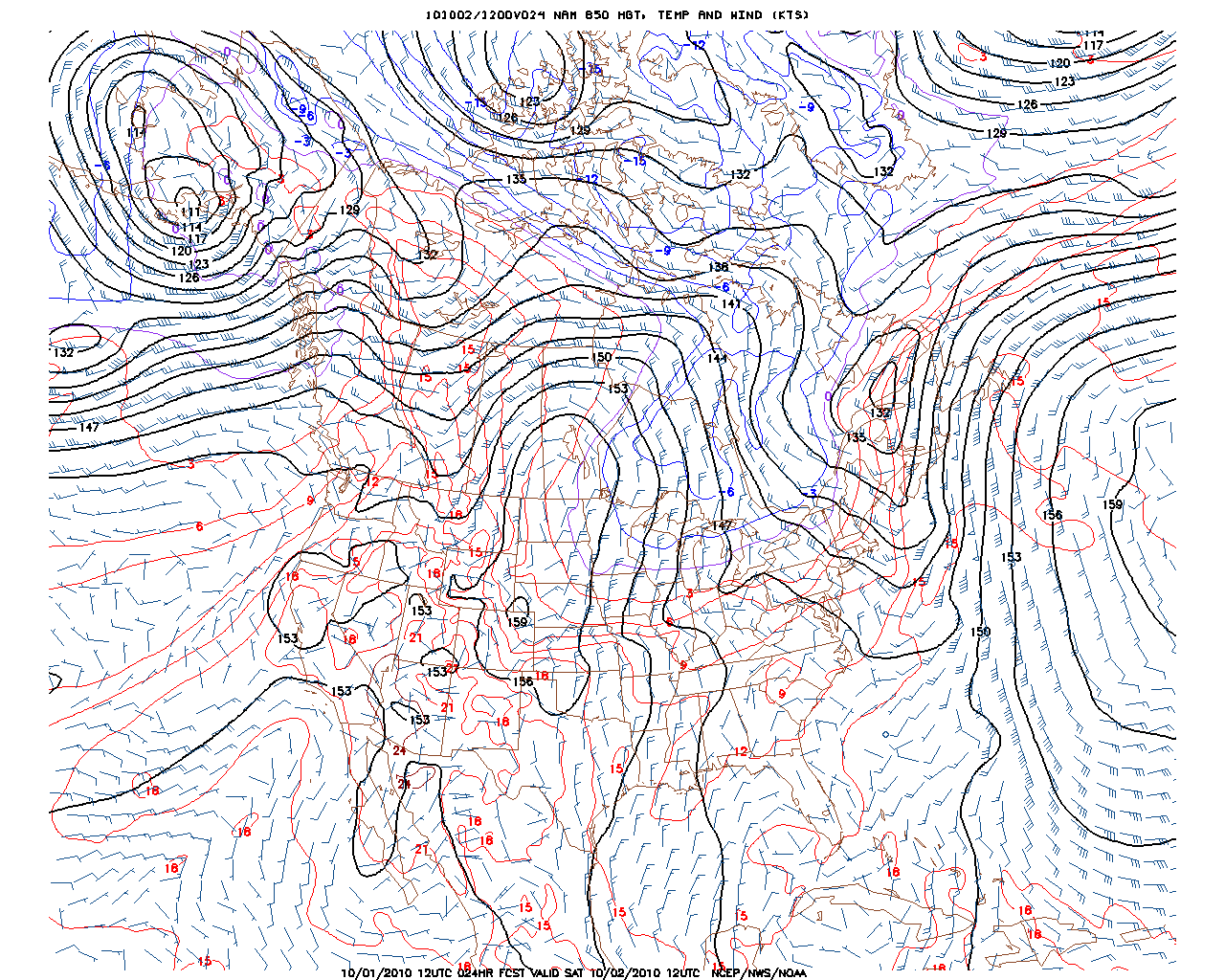
It will however dig enough to bring temps in the north country down to below freezing. By Sat. morning temps at 850mb should be around or below 0c. Models differ but I think this model prob is pretty accurate.
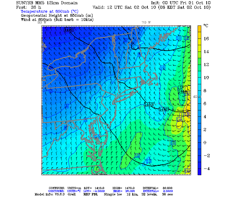
Here is another look at the temp profile.
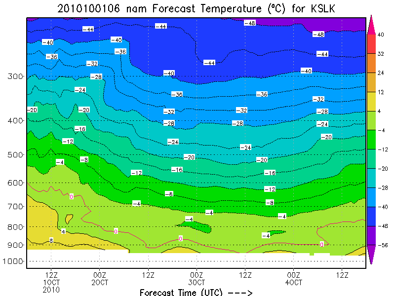
In this image focus on the period from 00Z 2 OCT to 00Z 3 OCT and particularly the period around 12Z 2 OCT. (At this time of year EST is UTC – 4 hours, in DST its UTC-5) This is the period that will support flutter the most. In this period you can clearly see the temps supporting non-liquid precip….
Now all we need is some moisture….and that’s where the problem lies.
If you look at the 850mb winds below, you can see strong winds from the NW.
Now normally this is good for upslope snow BUT that’s only if there is decent moisture in the system. So ideally you want upstream moisture and locally high RH values. Upstream moisture would be a vertically stacked, maritime low in canada or the great lakes. Here there isn’t that. Upstream is dry Canada.
So at the least we need some decent RH values. With high RH the moist air forced up by the orographic flow can reach saturation point and precip can occur. If you have dry upper air…this system shuts down and you prob. just get clouds.
So here is the RH profile:
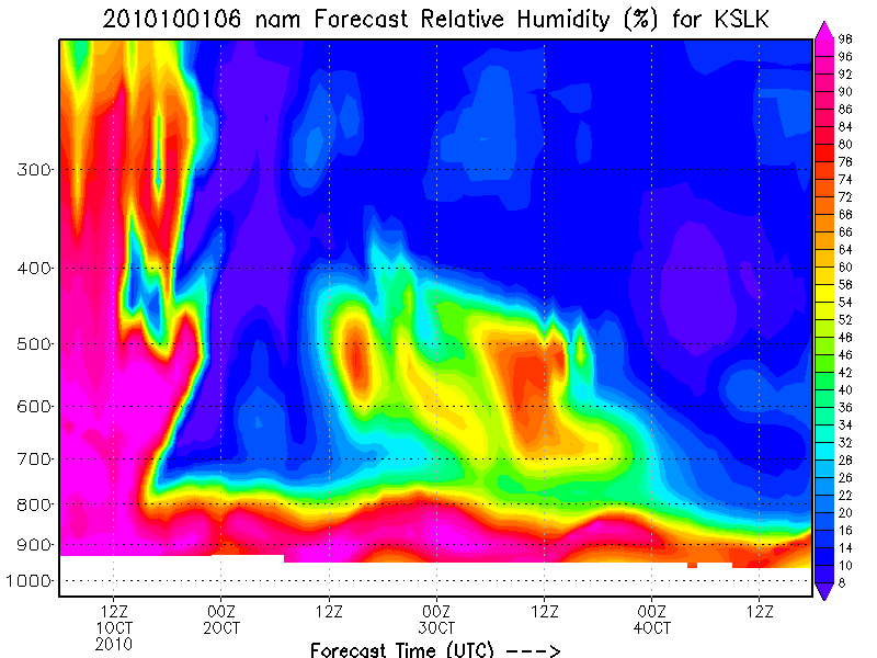
As you can see the air is pretty dry overnight but as we get to 12z (8am) the RH values raise. At the same time, omega increases at this time:
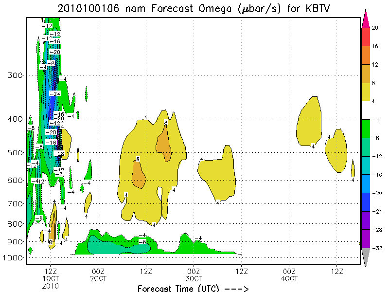
Positive values of Omega indicate downward vertical motion which is not conducive to snowfall. However this might be offset by the UVV supplied by the mountains and N/NW flow. Now clearly since we are dealing with limited moisture I don’t think we’re talking about much more than a coating….however its still nice to be talking about this. So if you get up early on saturday and head up in the hills keep your eyes out for a flake. Remember to tweet us at FISWX…include a pic if your are so inclined.
As a note…I really like the look of October…thinking some October turns are very possible. Not sure about November but I’m liking what I see for October.

7 Comments
Leave a Reply
|
|||
| Home |

-
Search
New Comments
Surfing Safari on Burlington's Booth Street | Seven Days said: “[…] lights and snapped away. Here’s a...(read more)” about Surfing the Flood
macbook repair seattle said: “macbook repair seattle Let’s get it started...(read more)” about Let’s get it started
Greg said: “Thanks for all this great info. And...(read more)” about Skiing Mt. Colden’s Trap Dike
Greg said: “Definitely late, but always welcome!” about Skiing Mt. Colden’s Trap Dike
Bob said: “[* Shield Security plugin marked this comment...(read more)” about Skiing Mt. Colden’s Trap Dike
Regular paint Maintenance said: “Regular paint Maintenance Behind The Schuss(ic) :...(read more)” about Behind The Schuss(ic)
The 2012-13 Ski Season in Photos #13 | NY Ski Blog said: “[…] tweeting about big Memorial Day snow...(read more)” about pow
ml242 said: “LuckyLuc and MadPat on the same day?...(read more)” about Deep Cover Anthropology
Twitter Feed
-
Categories
- Skiing (438)
- Weather (188)
- WTF (5)
- Quick Update (173)
- Full Trip Report (165)
- WebiGNARs (45)
- General Interest (38)
- Site News (27)
- Summer (59)
- Hiking (26)
- Swimming (15)
- Climbing (13)
- Longboarding (3)
- Whitewater Kayaking (2)
- Mountain Biking (1)
- SPA (16)
- Gear Review (8)
-
Archive
- October 2018
- June 2017
- November 2016
- October 2016
- March 2016
- January 2016
- October 2015
- February 2015
- January 2015
- December 2014
- November 2014
- October 2014
- September 2014
- July 2014
- April 2014
- March 2014
- February 2014
- January 2014
- December 2013
- November 2013
- October 2013
- September 2013
- August 2013
- June 2013
- May 2013
- April 2013
- March 2013
- February 2013
- January 2013
- December 2012
- November 2012
- October 2012
- September 2012
- August 2012
- July 2012
- June 2012
- May 2012
- April 2012
- March 2012
- February 2012
- January 2012
- December 2011
- November 2011
- October 2011
- September 2011
- August 2011
- July 2011
- June 2011
- May 2011
- April 2011
- March 2011
- February 2011
- January 2011
- December 2010
- November 2010
- October 2010
- September 2010
- August 2010
- July 2010
- June 2010
- May 2010
- April 2010
- March 2010
- February 2010
- January 2010
- December 2009
- November 2009
- October 2009
- September 2009
- August 2009
- July 2009
- June 2009
- April 2009
- March 2009
- February 2009
- January 2009
- December 2008
- November 2008
- October 2008
- April 2008
- March 2008
- February 2008
-
Friends of F.I.S.

About Us:
We are a group of powder hungry, east-coast-bred, world-traveling skiers and riders who Earn Our Turns to bring you the best stoke a click-of-the-mouse can buy.We hope our adventures inspire you to Earn Your Turns as well!
LEARN MORE

Latest Weather
When one makes meatballs, one must begin with quality meats: ...
Read more in: Meatballs! (read more)
Greg
wrote on October 1st, 2010 at 12:08 pmwoah
thanks Lionel. So Saturday morning huh? not sunday?
Harvey44
wrote on October 1st, 2010 at 9:34 pmI’d heard Sunday AM too.. but what do I know … I’m just an unfrozen caveman lawyer. OR wait…? Keep up the good work LH … I’m a religious FIS/LH weather retweeter.
bushman
wrote on October 2nd, 2010 at 8:03 amReading this spurs us to go ahead and hike it, knowing that pretty soon they’ll be enough to slide and turn on rock skis. And, being New England, it’s possible that while you’re doing hiking the temp/RH/wind, etc., shifts and triggers flutter while you’re snapping the top buckles. That’s the payback for taking a chance and hiking up, defying the flatlanders who called you nuts, and won’t believe there was anything there until you smack them with the snowball preserved in your tuke… Thanks for the detailed report LH
natron
wrote on October 3rd, 2010 at 8:07 amthis week? having a hard time locking in a forecast for flutter for mt.w.? lot of conflicting reports.. what’s the 411, LH?
Vincenzo
wrote on October 4th, 2010 at 10:20 amso how will la nina effect northern vermont this year?
billski
wrote on October 4th, 2010 at 12:29 pmBring on the Flutter!
if there are no flakes, but it’s still cold enough, it that Flutter Nutter? ;)
Greg
wrote on October 4th, 2010 at 3:51 pmFluttella actually!