
(UPDATED) In through the backdoor…upper elevation snow possible monday
There is an interesting situation likely to unfold monday into tuesday which could lead to some more snows across the higher terrain of the northeast as a storm system backs in – retrogrades- west into the northeast.
Currently, a trough of very cold air has settled over the northeast. Along the eastern edge exists the remnants of last weeks messy rain storm. Along this front a weak wave will travel northeast tomorrow. As it does it will tighten weakly and develop a mild surface low pressure center. As this develops it will retrograde back to the west into the cold air.
This, combined with a tap of Atlantic moisture will result in the system throwing a right cross into the Northeast.
You can see it clearly in the image below:

Notable is that the right cross will wrap warm around around from the east and towards the north of the system. At the same time in the west and southwest will exist cold air as the storm wraps around it. By Monday afternoon temps at 4500 feet will be between 0c and -5 c in a large pocket from central VT, through the Berkshires, into Con., the Catskills and around the southern ADK.
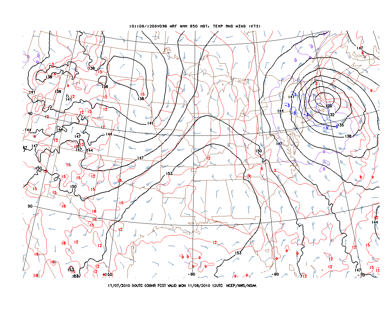
Also- at this time the air over the high white mountains might be below 0c as well.
As this unfolds the moisture coming in from the Atlantic will override this mid-level cold air and produce some wintry precip. It’s very hard to judge right now what exactly will pan out. My best guess right now is that we’ll see a mix of snow, sleet and unknown precip through the afternoon. Totals will be tricky to judge but hey- it’s not even thanksgiving so any snow is worth talking about. Regardless we aren’t talking a ton of snow. Maybe 2-4 for the ADK, 2-4 for the High Greens, 1-3 for southern vt and the berks. THe winner could be the high slopes of Mt. Washington where 4-10 inches are possible.
UPDATE
A quick peek at the radar and mesoanalysis shows that a large pocket of dry air worked into the center of the low and it has taken on a pretty interesting shape. All in all it looks like the best snow for now and the rest of the afternoon will fall in the catskills. As for Mt. Washington above, it looks like temps warmed a little too much as the low took more of a tilt than forcasted and warmer air worked in from the east.

3 Comments
Leave a Reply
|
|||
| Home |

-
Search
New Comments
Surfing Safari on Burlington's Booth Street | Seven Days said: “[…] lights and snapped away. Here’s a...(read more)” about Surfing the Flood
macbook repair seattle said: “macbook repair seattle Let’s get it started...(read more)” about Let’s get it started
Greg said: “Thanks for all this great info. And...(read more)” about Skiing Mt. Colden’s Trap Dike
Greg said: “Definitely late, but always welcome!” about Skiing Mt. Colden’s Trap Dike
Bob said: “[* Shield Security plugin marked this comment...(read more)” about Skiing Mt. Colden’s Trap Dike
Regular paint Maintenance said: “Regular paint Maintenance Behind The Schuss(ic) :...(read more)” about Behind The Schuss(ic)
The 2012-13 Ski Season in Photos #13 | NY Ski Blog said: “[…] tweeting about big Memorial Day snow...(read more)” about pow
ml242 said: “LuckyLuc and MadPat on the same day?...(read more)” about Deep Cover Anthropology
Twitter Feed
-
Categories
- Skiing (438)
- Weather (188)
- WTF (5)
- Quick Update (173)
- Full Trip Report (165)
- WebiGNARs (45)
- General Interest (38)
- Site News (27)
- Summer (59)
- Hiking (26)
- Swimming (15)
- Climbing (13)
- Longboarding (3)
- Whitewater Kayaking (2)
- Mountain Biking (1)
- SPA (16)
- Gear Review (8)
-
Archive
- October 2018
- June 2017
- November 2016
- October 2016
- March 2016
- January 2016
- October 2015
- February 2015
- January 2015
- December 2014
- November 2014
- October 2014
- September 2014
- July 2014
- April 2014
- March 2014
- February 2014
- January 2014
- December 2013
- November 2013
- October 2013
- September 2013
- August 2013
- June 2013
- May 2013
- April 2013
- March 2013
- February 2013
- January 2013
- December 2012
- November 2012
- October 2012
- September 2012
- August 2012
- July 2012
- June 2012
- May 2012
- April 2012
- March 2012
- February 2012
- January 2012
- December 2011
- November 2011
- October 2011
- September 2011
- August 2011
- July 2011
- June 2011
- May 2011
- April 2011
- March 2011
- February 2011
- January 2011
- December 2010
- November 2010
- October 2010
- September 2010
- August 2010
- July 2010
- June 2010
- May 2010
- April 2010
- March 2010
- February 2010
- January 2010
- December 2009
- November 2009
- October 2009
- September 2009
- August 2009
- July 2009
- June 2009
- April 2009
- March 2009
- February 2009
- January 2009
- December 2008
- November 2008
- October 2008
- April 2008
- March 2008
- February 2008
-
Friends of F.I.S.

About Us:
We are a group of powder hungry, east-coast-bred, world-traveling skiers and riders who Earn Our Turns to bring you the best stoke a click-of-the-mouse can buy.We hope our adventures inspire you to Earn Your Turns as well!
LEARN MORE

Latest Weather
When one makes meatballs, one must begin with quality meats: ...
Read more in: Meatballs! (read more)
bushman
wrote on November 8th, 2010 at 7:46 amhaik, some snow, then rain 90 minutes north of NYC at 7:00 AM, just enough to put a skin on the ground. figure it’ll be 3-4″ of snow in VT hills though waether alert says ice, snow, then rain outside Burlington. picking up skis after tune up this week–shop says an edge is gone. Pretty sure its stuck in a birch halfway down Timbucktu @ Jay P. these will last till demos go on sale.
Corbeau in Sutton Qué.
wrote on November 8th, 2010 at 10:51 am“Maybe 2-4 for the ADK, 2-4 for the High Greens, 1-3 for southern vt and the berks. THe winner could be the high slopes of Mt. Washington where 4-10 inches are possible.”
“Inches”? I thought you had gone metric, Lionel, “because all the cool kids are doing it”…
Signed:
Confused in Canada