
Long duration event set to affect Wasatch range (UPDATED Sat. 11/20)
In the latest round of our weekly series entitled “Hey- it snows a lot in the Wasatch” we will feature a long duration event. From Sunday until Tuesday of next week a large western trough will swing into the intermountain region and bring a prolonged period of mountain snowfall.
Saturday 11/20/10 Update
Things are looking still very good for a large and wet pacific storm to impact the Wasatch range over the next 96 hours. Starting today – later in the day- snow will begin to break out across the range along a sw flow. As the trough moves inland tonight, tomorrow snow will peak in intensity. High res gridded models show a very achievable 1.75 to 2.25 liquid equivalent precipitation by around midnight sunday. Then, as the trough moves over the great basin, a break in the snowfall should be ended by an unstable westerly flow. The latest time height diagram shows a good saturation of water vapor and pretty decent lapse rates from monday evening through at least Wednesday morning. With the orographic lifting the western slopes of the Cottonwoods should do very very well. Another 1 to 2 inches of liquid equivalent are very possible. Notably I use liquid equivalent here because with the steep vertical motion and sw flow gruapel is very likely in the first 1/2 of the storm. Accordingly total snow depth will be a little tougher to judge as graupel doesn’t really pile up.
YAY STORMS!!
ORIGINAL DISCUSSION
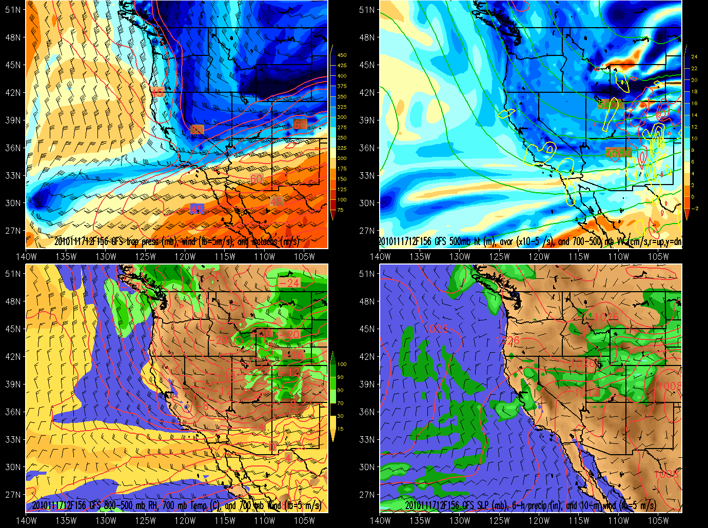
As we move into the weekend a large pacific trough will deepen as it swings down out off the coast of the California. As it deepens and swings into california and the west it will bring with it upper level divergence and an unstable moist airmass. Overall the system will first bring precip on a south west flow, then as the trough moves through region it will bring precip enhanced by a western flow. Precip will begin on sunday and last through at the least tuesday.
The models have a very clear that the first precipitation should begin later in the day sunday:
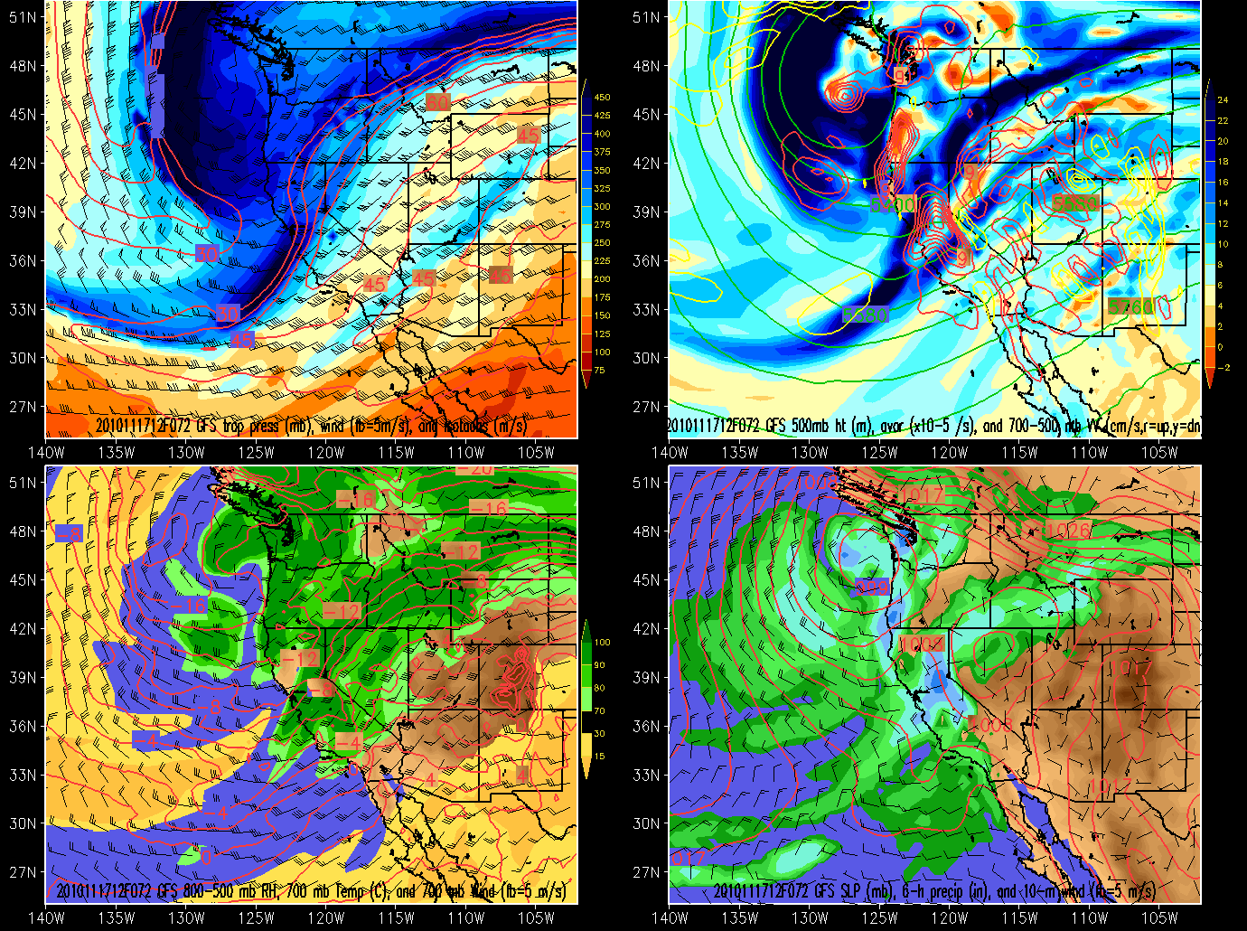
Then the trough moves in full bore by Sunday.
As we can see clearly the beginning of the event will feature snow on a strong S/W flow. 24 hours later the strongest upper level divergence will spike as the trough remains it’s eastward progression through the intermountain west. Clearly the models have picked up on this and spiked the precip. rates in the central wasatch.
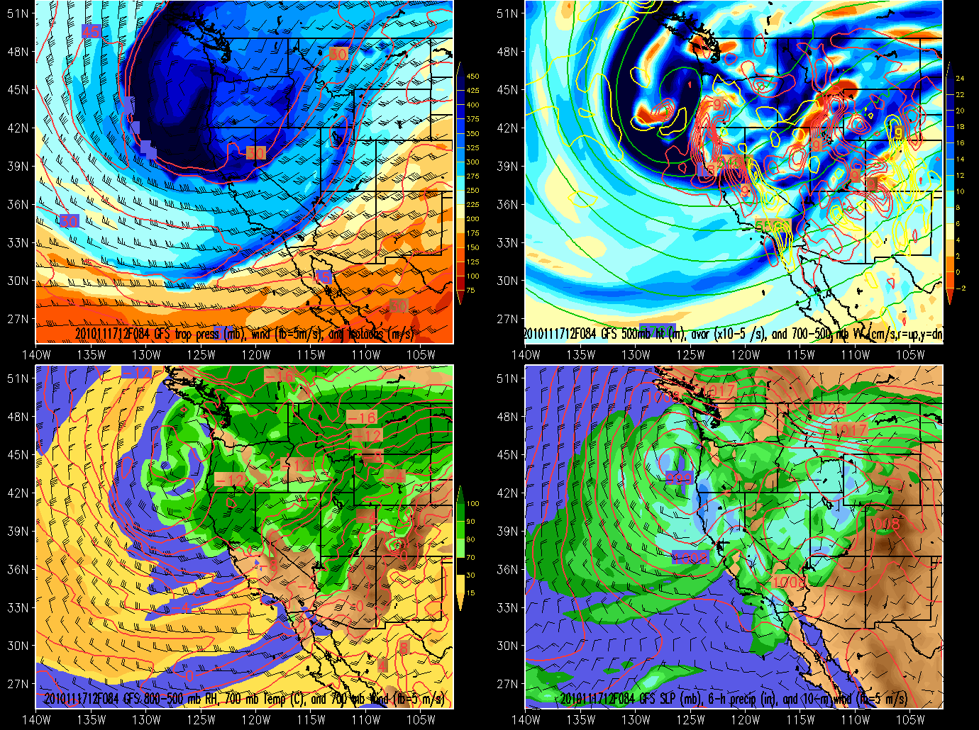
Once the trough flattens out, a moist airmass will persist. As the trough moves east, the flow will turn westerly. Given the moist airmass and the western flow, precip should remain over the Wasatch on Monday into Tuesday
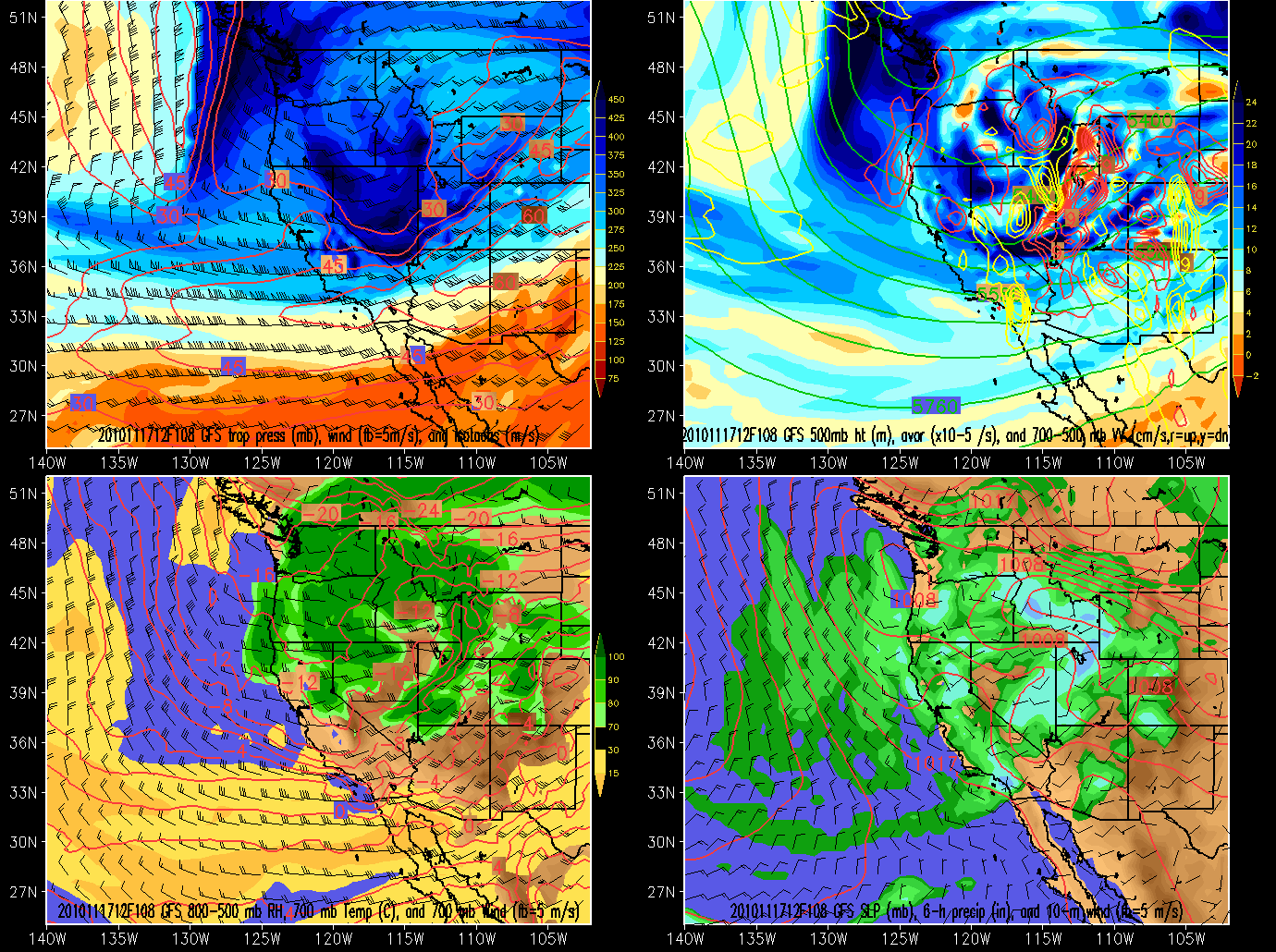
And still persisting….tuesday into Wednesday.
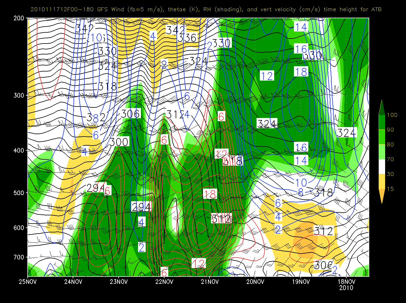
Looking at the higher resolution time-height series for Alta-UT shows the long duration event with two spikes of upward motion that co-incide with the heightened model periods of precip- sunday night into monday and tuesday.
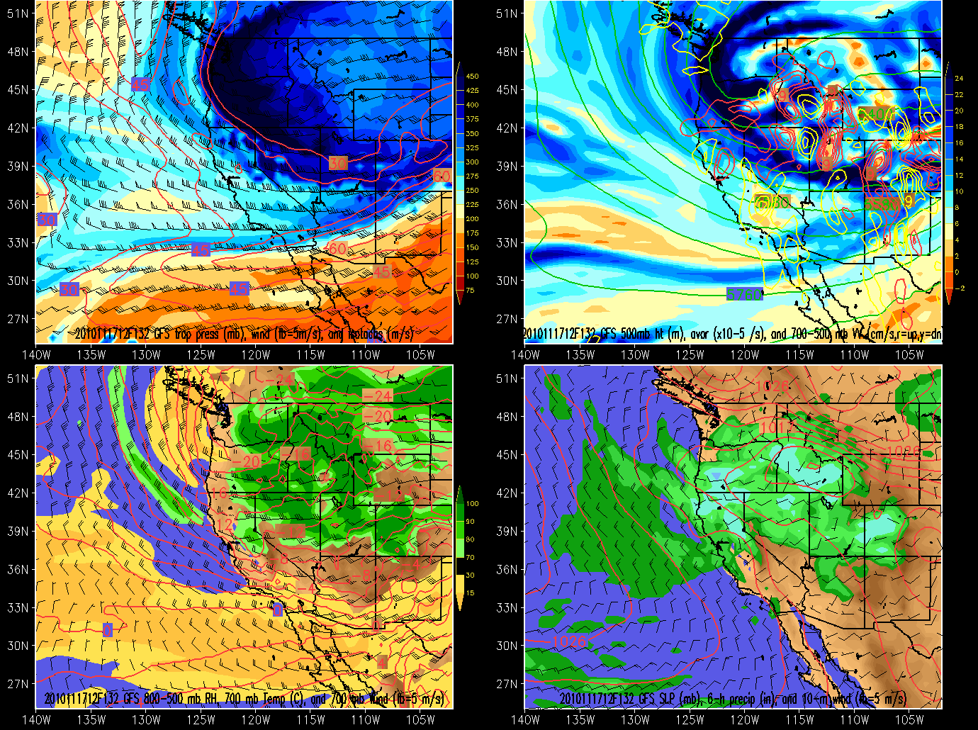
Adding all this up I’d suspect upper cottonwoods storm totals to reach 2-3 feet with more possible if the western flow remains steady and the vertical motion matches up.
11/18/10 Update
Models are a little more progressive and show snow breaking out later in the day on saturday across the wasatch. With Omega values greater than -6 likely there will be adequate instability. Upward Vertical motion is also wvery high with spikes Sunday afternoon and night and then again tuesday early morning. All in all things look good.
Totals still look around 3 feet in the Cottonwoods. However this will have to be updated when the High Res. models come in range over the weekend.
Should be a great opening weekend at Alta!

6 Comments
Leave a Reply
|
|||
| Home |

-
Search
New Comments
Surfing Safari on Burlington's Booth Street | Seven Days said: “[…] lights and snapped away. Here’s a...(read more)” about Surfing the Flood
macbook repair seattle said: “macbook repair seattle Let’s get it started...(read more)” about Let’s get it started
Greg said: “Thanks for all this great info. And...(read more)” about Skiing Mt. Colden’s Trap Dike
Greg said: “Definitely late, but always welcome!” about Skiing Mt. Colden’s Trap Dike
Bob said: “[* Shield Security plugin marked this comment...(read more)” about Skiing Mt. Colden’s Trap Dike
Regular paint Maintenance said: “Regular paint Maintenance Behind The Schuss(ic) :...(read more)” about Behind The Schuss(ic)
The 2012-13 Ski Season in Photos #13 | NY Ski Blog said: “[…] tweeting about big Memorial Day snow...(read more)” about pow
ml242 said: “LuckyLuc and MadPat on the same day?...(read more)” about Deep Cover Anthropology
Twitter Feed
-
Categories
- Skiing (438)
- Weather (188)
- WTF (5)
- Quick Update (173)
- Full Trip Report (165)
- WebiGNARs (45)
- General Interest (38)
- Site News (27)
- Summer (59)
- Hiking (26)
- Swimming (15)
- Climbing (13)
- Longboarding (3)
- Whitewater Kayaking (2)
- Mountain Biking (1)
- SPA (16)
- Gear Review (8)
-
Archive
- October 2018
- June 2017
- November 2016
- October 2016
- March 2016
- January 2016
- October 2015
- February 2015
- January 2015
- December 2014
- November 2014
- October 2014
- September 2014
- July 2014
- April 2014
- March 2014
- February 2014
- January 2014
- December 2013
- November 2013
- October 2013
- September 2013
- August 2013
- June 2013
- May 2013
- April 2013
- March 2013
- February 2013
- January 2013
- December 2012
- November 2012
- October 2012
- September 2012
- August 2012
- July 2012
- June 2012
- May 2012
- April 2012
- March 2012
- February 2012
- January 2012
- December 2011
- November 2011
- October 2011
- September 2011
- August 2011
- July 2011
- June 2011
- May 2011
- April 2011
- March 2011
- February 2011
- January 2011
- December 2010
- November 2010
- October 2010
- September 2010
- August 2010
- July 2010
- June 2010
- May 2010
- April 2010
- March 2010
- February 2010
- January 2010
- December 2009
- November 2009
- October 2009
- September 2009
- August 2009
- July 2009
- June 2009
- April 2009
- March 2009
- February 2009
- January 2009
- December 2008
- November 2008
- October 2008
- April 2008
- March 2008
- February 2008
-
Friends of F.I.S.

About Us:
We are a group of powder hungry, east-coast-bred, world-traveling skiers and riders who Earn Our Turns to bring you the best stoke a click-of-the-mouse can buy.We hope our adventures inspire you to Earn Your Turns as well!
LEARN MORE

Latest Weather
When one makes meatballs, one must begin with quality meats: ...
Read more in: Meatballs! (read more)
icelanticskier
wrote on November 18th, 2010 at 7:58 amhmmmmm, wonder when high-dry time comes. bound to happen. with the wonderful start there, me thinks april could be a very good time to visit foofyland. folks will have had enough by then.
thanx for the updates!
rog
Patrickm
wrote on November 19th, 2010 at 4:11 pmThis forecast is perfect for a sea-level dweller like me! I’ll be up there from Tuesday through the Thanksgiving weekend and this looks to be the best Thanksgiving week skiing in years! Alta opened up today with 89 trails…now that’s an opening! NWS Salt Lake is thinking 3-4 feet is possible by Wednesday morning in the cottonwoods. Only problem is it will be COLD, below zero temps likely in the morning Tuesday-Thanksgiving day with highs only in the teens. Crossing my fingers this all plays out like forecasted!
bottleman
wrote on November 19th, 2010 at 5:45 pmYou’re not really complaining about the cold, are you?!
Patrickm
wrote on November 19th, 2010 at 5:57 pmNot complaining, just temps that cold catch my eye because I live in Louisiana most of the year! I’m just thrilled there will be great snow and can’t wait to get out there!
icelanticskier
wrote on November 20th, 2010 at 9:06 amhopefully you’ll be able to get to it……..
rog