
I hear you. I totally hear you. With 10 days before the traditional opening day it’s warm, wet and not looking great. Every day somebody asks me “what’s up? Am I going to ski my turkey gravy and stuffing off or am I’m going to get stuck with grandma going shopping for holiday sweaters and deals on new linens?” Well I’m here to tell you the truth. Its going to be close but there is a light at the end of the tunnel and it appears that winter wants to show up in the long range.
Beginning with large scale teleconnections:
The Arctic Oscilation:
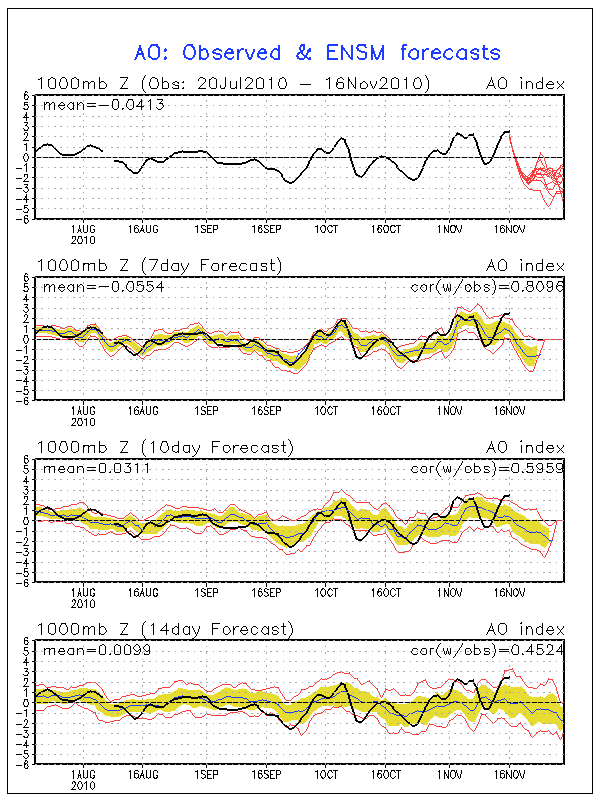
As we can see the consensus ensemble outlook has the AO heading and staying in the negative regime throughout the period. A negative phase of the AO favors the entry of cold air into the CONUS. As I approach it, the AO indicates to me the presence of cold air…other teleconnections indicate its location.
The NAO:
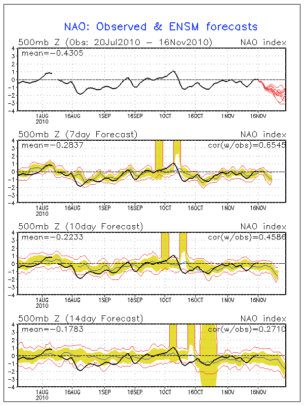
The NAO is a major teleconnection with significant impacts on the east coast weather. When the NAO is in the negative phase, stormy and cold weather is favored in the east. Based on the teleconnection forecast, it would appear that throughout the long term favorable conditions for eastern skiers would exits. However….
The PNA:
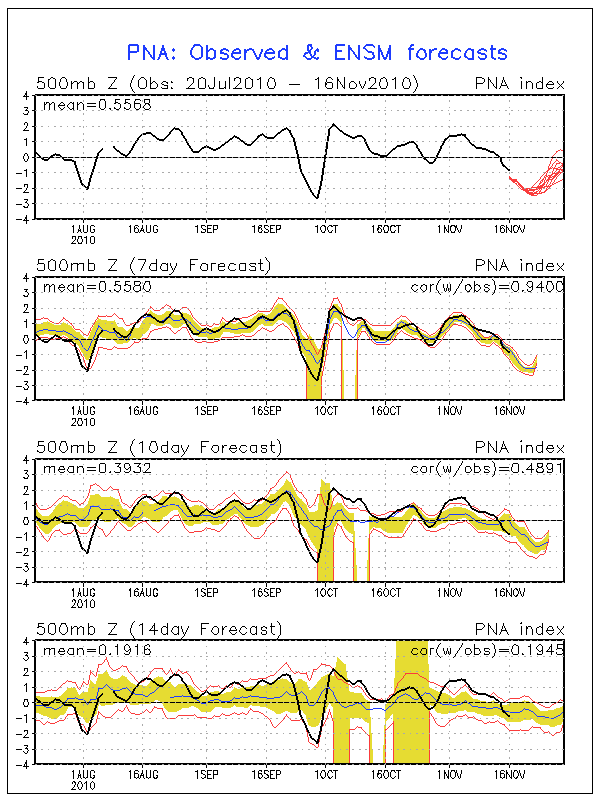
The PNA is a major player in the CONUS weather. It is sadly often overlooked. In the positive phase, above average heights are favored in the west with downstream below average heights in the east. In the negative phase the pattern is flip-flopped. My .02 cents says the PNA index overwhelms the NAO index in certain large scale weather patterns. The current Nina pattern we are in is one of those patterns.
Looking very closely at all these teleconnection forecasts leads to the conclusion that a period of transitory weather should exist from roughly this weekend until the 24th or so when the AO, NAO look to dive further negative, and the PNA importantly looks to climb towards the positive. As the PNA moves towards the neutral stage and the AO and NAO remain negative i’d expect a relaxation in any ridging in the east coast. Notably I wouldn’t expect the pattern to wholesale flip-flop because the PNA will only approach the Neutral stage and not head into the positive phase.
Looking at the models’ various solutions to see how this all plays out shows a period of unsettled weather with a large pattern change towards the end of the pattern. Beginning this weekend a somewhat zonal will bring slightly above average temps to much of the east cost ski world. Nights should be in the 20’s and thirties however. (UPDATE…Coming in a good deal colder for the weekend) A weak impulse will ripple through the pattern and maybe bring some light showers to the higher terrain. (Likely snow showers given the latest guidance). Then as we move into next week energy ejecting out of the west will start to flip the pattern around. The models deepen this energy along a stalled frontal boundary running from western NY to New Mexico/Texas. The models actually deepen this system into a powerful storm over the central great lakes which spikes east coast temps and provide one last slug of warm rain early next week. While some models bring more rain and some bring less, the overall consensus is rain. As the system clears towards the NE the PNA will be trending towards neutral and a large block of early season cold air will head into the CONUS. All the models show a deep intrusion of arctic (early season) air flowing into the country thanksgiving night. By black friday much of country would be in the freezer. Unfortunately I see this as a dry front with only a few lake effect snow showers downwind of the lakes. Importantly this cold air looks to lock in for a period of time and should allow any man-made snow to stick around for a while.

6 Comments
Leave a Reply
|
|||
| Home |

-
Search
New Comments
Surfing Safari on Burlington's Booth Street | Seven Days said: “[…] lights and snapped away. Here’s a...(read more)” about Surfing the Flood
macbook repair seattle said: “macbook repair seattle Let’s get it started...(read more)” about Let’s get it started
Greg said: “Thanks for all this great info. And...(read more)” about Skiing Mt. Colden’s Trap Dike
Greg said: “Definitely late, but always welcome!” about Skiing Mt. Colden’s Trap Dike
Bob said: “[* Shield Security plugin marked this comment...(read more)” about Skiing Mt. Colden’s Trap Dike
Regular paint Maintenance said: “Regular paint Maintenance Behind The Schuss(ic) :...(read more)” about Behind The Schuss(ic)
The 2012-13 Ski Season in Photos #13 | NY Ski Blog said: “[…] tweeting about big Memorial Day snow...(read more)” about pow
ml242 said: “LuckyLuc and MadPat on the same day?...(read more)” about Deep Cover Anthropology
Twitter Feed
-
Categories
- Skiing (438)
- Weather (188)
- WTF (5)
- Quick Update (173)
- Full Trip Report (165)
- WebiGNARs (45)
- General Interest (38)
- Site News (27)
- Summer (59)
- Hiking (26)
- Swimming (15)
- Climbing (13)
- Longboarding (3)
- Whitewater Kayaking (2)
- Mountain Biking (1)
- SPA (16)
- Gear Review (8)
-
Archive
- October 2018
- June 2017
- November 2016
- October 2016
- March 2016
- January 2016
- October 2015
- February 2015
- January 2015
- December 2014
- November 2014
- October 2014
- September 2014
- July 2014
- April 2014
- March 2014
- February 2014
- January 2014
- December 2013
- November 2013
- October 2013
- September 2013
- August 2013
- June 2013
- May 2013
- April 2013
- March 2013
- February 2013
- January 2013
- December 2012
- November 2012
- October 2012
- September 2012
- August 2012
- July 2012
- June 2012
- May 2012
- April 2012
- March 2012
- February 2012
- January 2012
- December 2011
- November 2011
- October 2011
- September 2011
- August 2011
- July 2011
- June 2011
- May 2011
- April 2011
- March 2011
- February 2011
- January 2011
- December 2010
- November 2010
- October 2010
- September 2010
- August 2010
- July 2010
- June 2010
- May 2010
- April 2010
- March 2010
- February 2010
- January 2010
- December 2009
- November 2009
- October 2009
- September 2009
- August 2009
- July 2009
- June 2009
- April 2009
- March 2009
- February 2009
- January 2009
- December 2008
- November 2008
- October 2008
- April 2008
- March 2008
- February 2008
-
Friends of F.I.S.

About Us:
We are a group of powder hungry, east-coast-bred, world-traveling skiers and riders who Earn Our Turns to bring you the best stoke a click-of-the-mouse can buy.We hope our adventures inspire you to Earn Your Turns as well!
LEARN MORE

Latest Weather
When one makes meatballs, one must begin with quality meats: ...
Read more in: Meatballs! (read more)
Greg
wrote on November 17th, 2010 at 8:53 amThank you Lionel. Probably the clearest explanation of the effects-to-skiers of the AO/NAO/PNA triumvirate to date
powhounddd
wrote on November 17th, 2010 at 10:31 amditto to that.
I enjoy learning in general and more about weather modeling in particular, especially when there’s no snow and I start to feel like an ogre, a cave troll, or a man trapped in an 8×8 room with no windows and nothing but elevator music looping…
Better to hear honest (even if not great) news than a load of BS anyday. Thanks LH!!!
Keith
wrote on November 17th, 2010 at 11:04 amRained pretty go on this side of the pond last night but not major down pours. Well at least not in the home of the High Peaks. Warm too. Sounds like another week of warm/wet before the cold sinks in… Donny Afternoon is asking about storm possibility coming the Friday after Thanksgiving… Any beta on that??
Lionel Hutz
wrote on November 17th, 2010 at 11:43 amCheck back tonight. I’m digesting it. These thoughts had to come first.
WhiteWoodchuck
wrote on November 17th, 2010 at 2:54 pmThanks for the update Lionel. After reading your updates like this I get the hankerin’ to head up to LSC and take some more meteorology courses to truly appreciate your writings – perhaps after I pay off my kid’s LSC tuition bills I’ll quit working in the flatlands and do just that :) Keep up the great work! WWC