
Hill Life
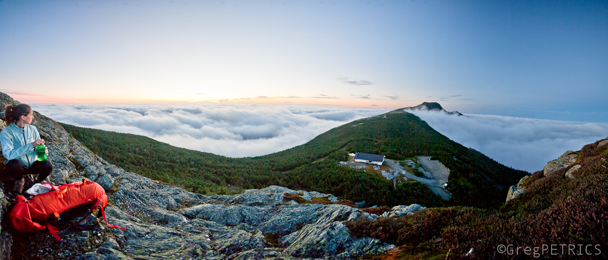
Unlike still life photography, Hill Life leaves no time to ponder a subject. Hill Life reveals itself for merely a few seconds before disappearing just as quickly. The angle of the light will change. The skier emerges from the snow. The action is over. You must be ready. If you miss a moment of Hill Life, it’s gone forever.
All photos are available for purchase. See each photo for details. Prices include shipping. Please email sales@famousinternetskiers.com with any questions, or to arrange a purchase via paypal.
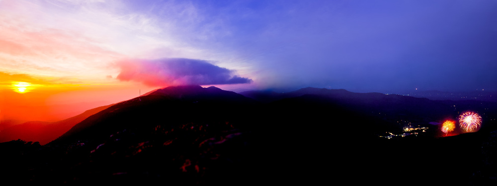
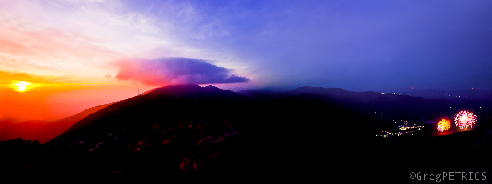
Stowe Fireworks — July 5, 2014. The sun sets in the west as Stowe Mountain Resort launches fireworks in the east. The Chin of Mount Mansfield is visible at center — 12″X36″ Board Mounted — $310
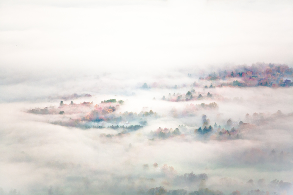
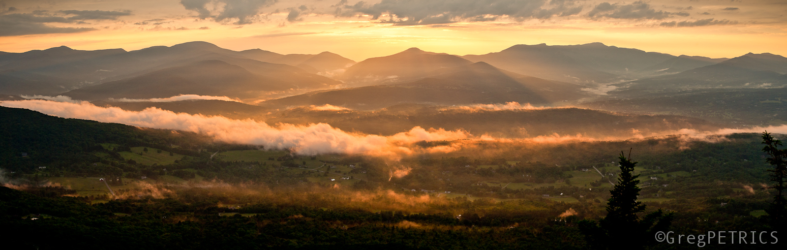
Stowe Hollow Fog — Early morning fog blankets the Stowe Hollow neighborhood — 10″X20″ Wrapped Board — $200
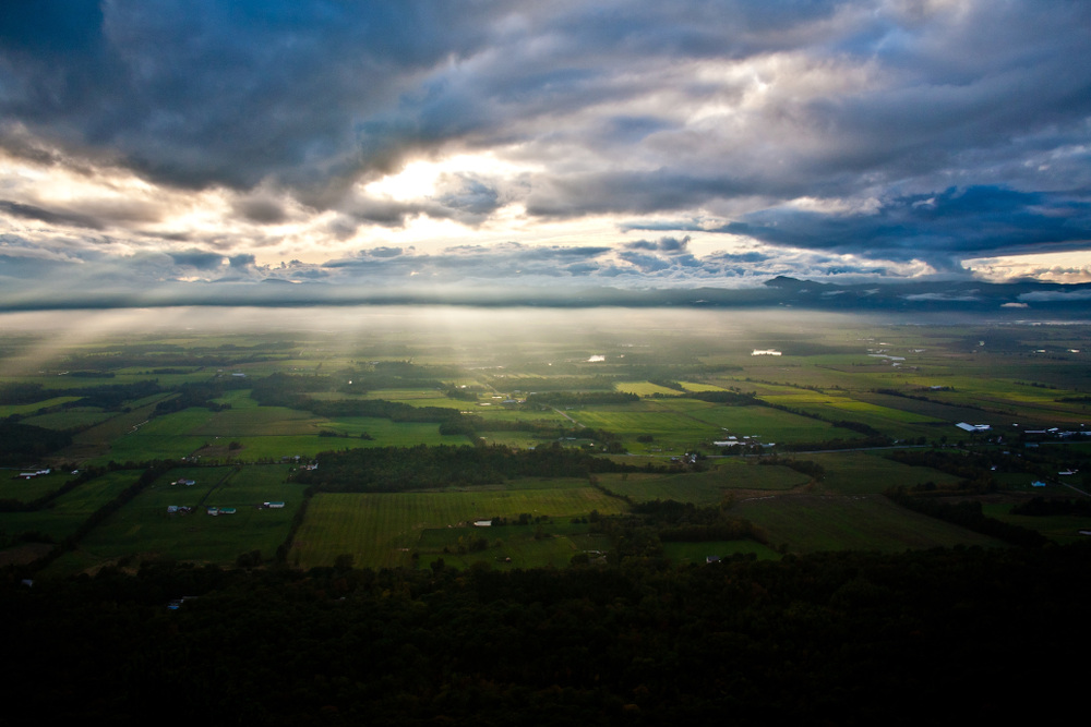
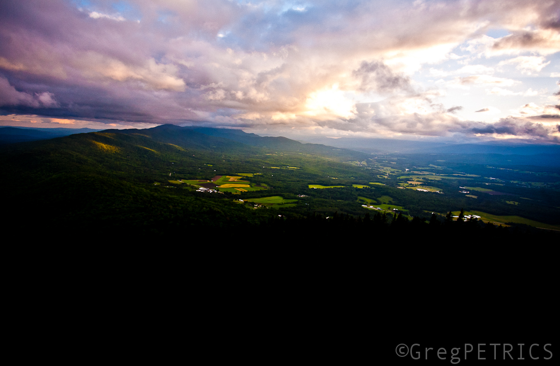
City of Gold — Sunset over the Stowe Valley after a rain storm — 20″X20″ Wrapped Board Triptych (three-panel) — $540
Rattlesnake Sunset — The sun sets over the Adirondacks as seen from Snake Mountain in the Champlain Valley — 20″X30″ Wrapped Board — $400
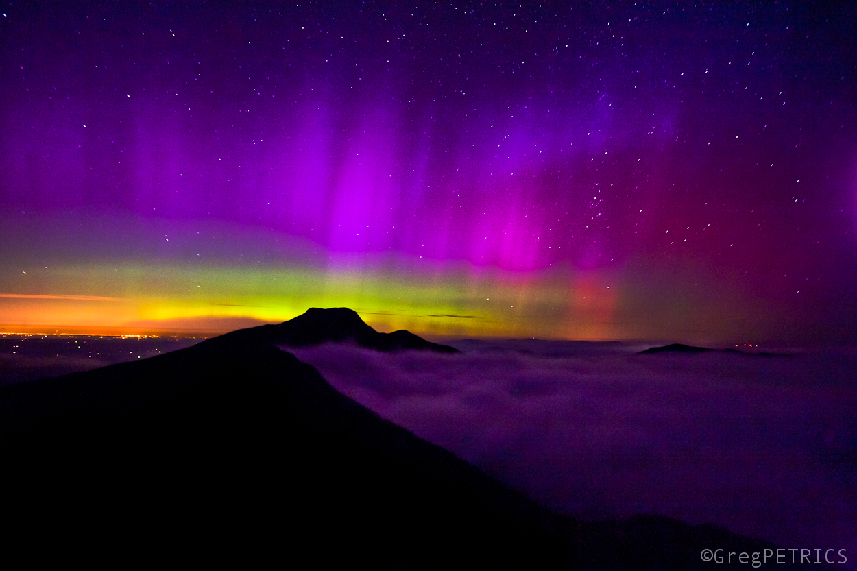
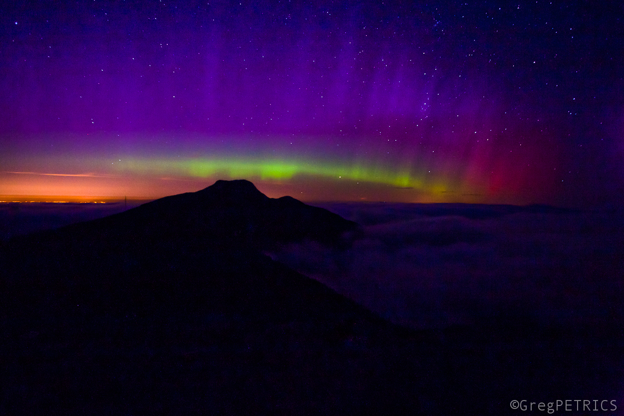
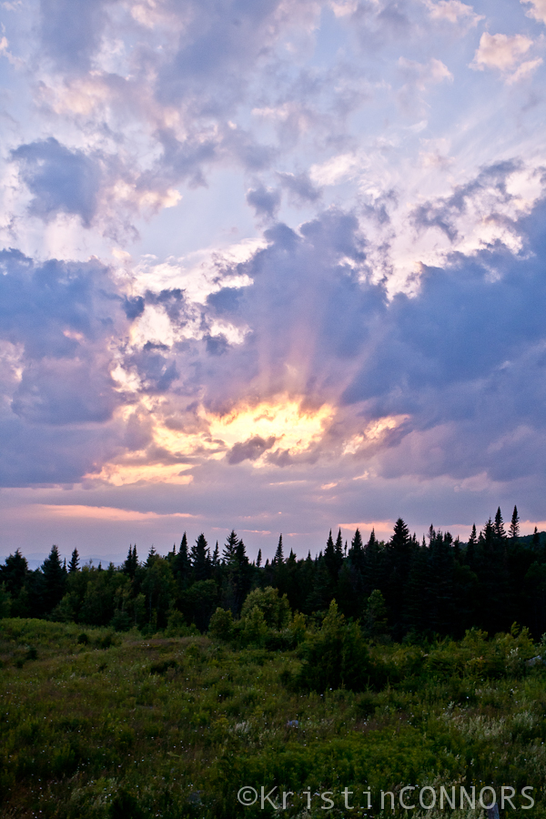
Aurora Borealis over Mount Mansfield — The aurora borealis shimmers above the chin of Mount Mansfield, and an undercast at 9 PM on September 12, 2014 — 24″X36″ Aluminum — $500
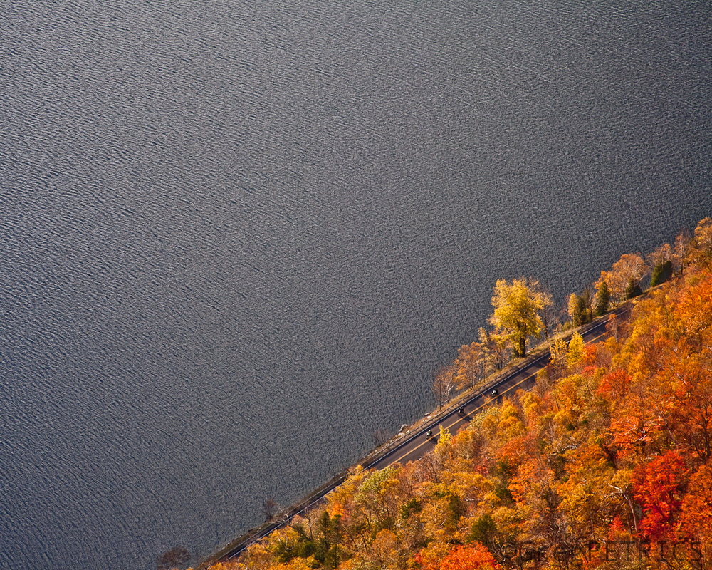
Pisgah — Foliage envelopes Route 5A alongside Lake Willoughby at the base of Mount Pisgah — 12″X18″ Wrapped Board — $220
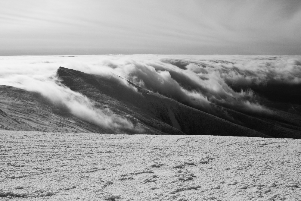
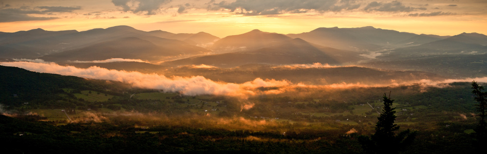
Clouds Over Monroe — Low clouds slide in from the south east over Mount Monroe in the Presidential Range of New Hampshire — 20″X30″ Wrapped Board — $400
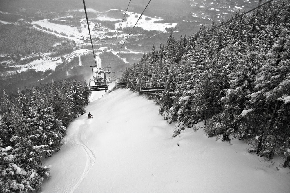
Liftline — Alexander LaRosa schusses Upper Liftline at Stowe Mountain Resort — 12″X18″ Board Mounted — $200
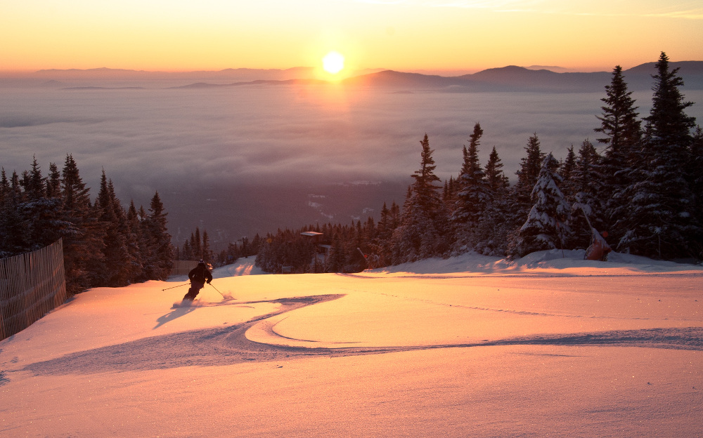
Lord Sunrise — Alexander LaRosa enjoys a dusting of snow and a sunrise on Upper Lord at Stowe Mountain Resort — 20″X30″ Framed Print — $200
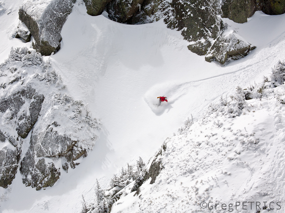
The Gulf — Christian Theberge harvests some fresh snow in the Great Gulf just north of Mount Washington, New Hampshire — 20″X30″ Framed Print — $200
Gut Check — Jake Evans prepares to descend Cass’ Gully on Mount Mansfield — 10″X20″ Wrapped Board — $120
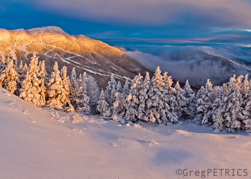
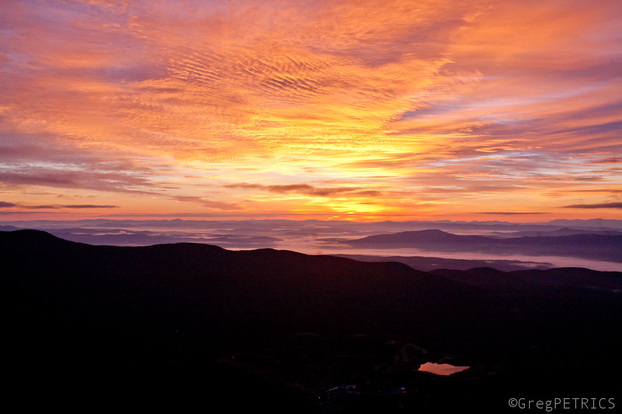
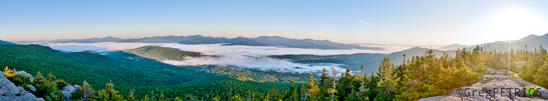
Hill Life — First light on Mount Mansfield — 16″X24″ Wrapped Board Triptych (three-panel) — $540
Read more about Hill Life in the Winter 2015 issue of Stowe Guide and Magazine available in many locations around Northern Vermont.
About Greg.
Greg Petrics, Ph.D., is Assistant Professor of Mathematics at Johnson State College, and co-founder of FamousInternetSkiers.com. His photography captures fleeting moments of action, beauty, and joy in the mountains, particularly those around Stowe, Vermont. His mathematical research studies sub-Riemannian minimal surfaces in non-Euclidean spaces. His photography has appeared in Backcountry Magazine, Skiing Magazine, Ski Vermont Magazine, Stowe Magazine, and Stowe Mountain Resort materials, among others.
Charity.
10% of gross sales go to the Johnson State College Student Emergency Fund. Established in 2010, the fund assists enrolled JSC students with demonstrable need cover unexpected expenses so they can stay in college. To make contributions directly, contact Karen Madden (Karen.Madden@JSC.edu).
The [Arizona] Strip
 For my money, I’ll take the band of desert known as the Arizona Strip. It’s beautiful, raw, really damn hard to get to, and generally unencumbered by tourists gallivanting from one National Park rest stop to the next. It’s cleaved off from the rest of Arizona by the Colorado River and the Grand Canyon, meaning you can really only get to it from Nevada or Utah – with the little exception of the Glen Canyon Dam. But even that is over a hundred miles away from the nearest highway.
Personally, I’d enlarge the Strip and define it as an area from the top of Lake Powell to the bottom of Lake Mead, and on both sides of the River (Lake) for a hundred miles or so. With this expanded, albeit loosely defined and otherwise completely unofficial definition, you get everything from the Grand Canyon, to Lake Mead, to the Valley of Fire, to the Vermillion Cliffs, to Monument Valley, to the Virgin River Gorge, to Escalante and it’s Grand Stair Case National Monument, to Navajo Peak, the Little Colorado River Canyon, to Antelope Canyon, to Canyonlands, Kaibab National Forest, to Zion National Park, and to Beaver Dam Wash. All of it, and that’s just the short list. In this three hundred mile stretch you’ve got dozens of public lands with not many people and simples rules – leave with what you came with, and don’t ruin it for anyone else.
Click the image for a full map.
Mind you, this map isn’t a perfect outline of the Arizona Strip, but it is pretty good. It’s about as close as roads can take you to entering the strip without rafting down the Grand Canyon itself. You can see before what a giant area this is. Roundtrip it’s almost 1,000 miles to circle the dang thing. In addition to the myriad for Federal lands there’s a venerable list of Native American tribes who’ve called this land home for much longer than we have – Navajo, Hualapai, Havasupai, Hopi, Kaibab, Moapa. In many regards, I think the Native American land managers have done a substantially better job of preserving their lands than the Federal Government has. Some of the towns on reservation land are beat up – mobile homes, garbage, the like – but most of the rolling lands outside the towns are unbuilt, clean, free, roadless swaths that I imagine look much like they did 500 years ago.
I’ve been wanting to travel to Monument Valley and see their famous spires for myself ever since watching The Eiger Sanction, where Clint Eastwood and George Kennedy climbed Totem Pole one of the prominent towers in the valley in preparation for their trip to The Eiger. Unfortunately they didn’t bring along George, Clint’s amorous training partner.
In one of the best scenes in all of modern film, at least in my opinion, is when Clint and George summit the Tower after Clint’s led the final pitch.
George leans over to Cliff and says, “Clint, wouldn’t it be great to have a beer up here?”
“Sure, would,” Clint says, “but who would be crazy enough to bring beer all the way up here?”
“You would, you crazy son of a bitch,” as George leans over and pulls a cold 6 pack out of Clint’s back pack.
Now that you’ve got the lay of the land we can start a proper story. The desert might be famous for it’s solitude, or Solitaire as Abbey would say. But it’s most striking quality to me is it’s confounding weather. It’s either nice – hot, dusty, unbearable – or it’s not – rain, floods, blistering winds, general act of god type weather. Either way it’s almost always a little bit unpleasant, at least for part of the day. There are shining moments, typically early in the morning just as the sun has crested the horizon and it’s not been too hot, or have a torrential downpour as a rainbow comes out and basks the momentarily cooled desert floor.
Thunderstorms are finicky in the Desert. They’e one of my favorite parts because they’re hard to find and can be forecasted for weeks on end and never materialize. You can have a sunny day with not a cloud in the sky and then be suddenly doused in a downpour. They’re unpredictable, scarce and can be a bit dangerous. I’ve been in and out of Vegas a lot the last few months, so when a large front was forecast to spin up some storms on a Friday afternoon, I decided to head East and see if I could see these storms in action.
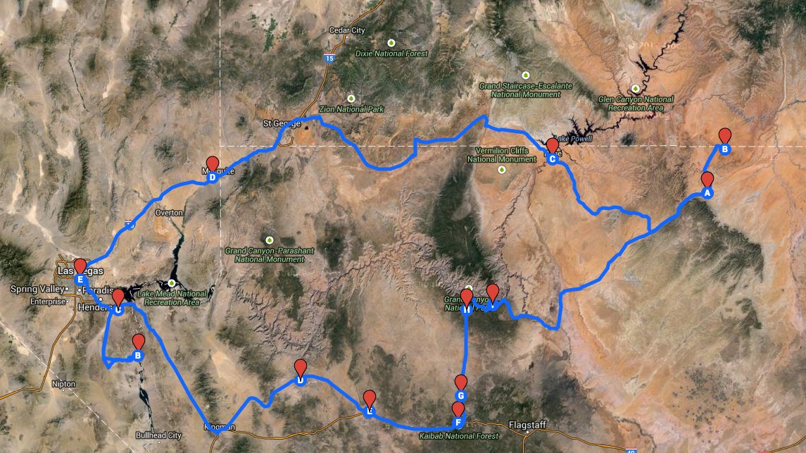
The Storm Prediction Center had issued a warning for strong thunderstorms, hail, and the possibility of tornados on Friday. Knowing this meant it might still not rain, I ventured out to see what their hype was about. I left intending to just camp by Boulder City for the night and return the next day. Utlimately I ended up driving the route in the map above, nearly 1,000 miles in 2 days to Monument Valley and back across almost all of the Arizona Strip.
The latest technical discussion from @NWSSPC #azwx #nvwx #cawx, http://t.co/OEgnRlO4Hq pic.twitter.com/NfSLs9oJSP
— NWS Las Vegas (@NWSVegas) September 26, 2014
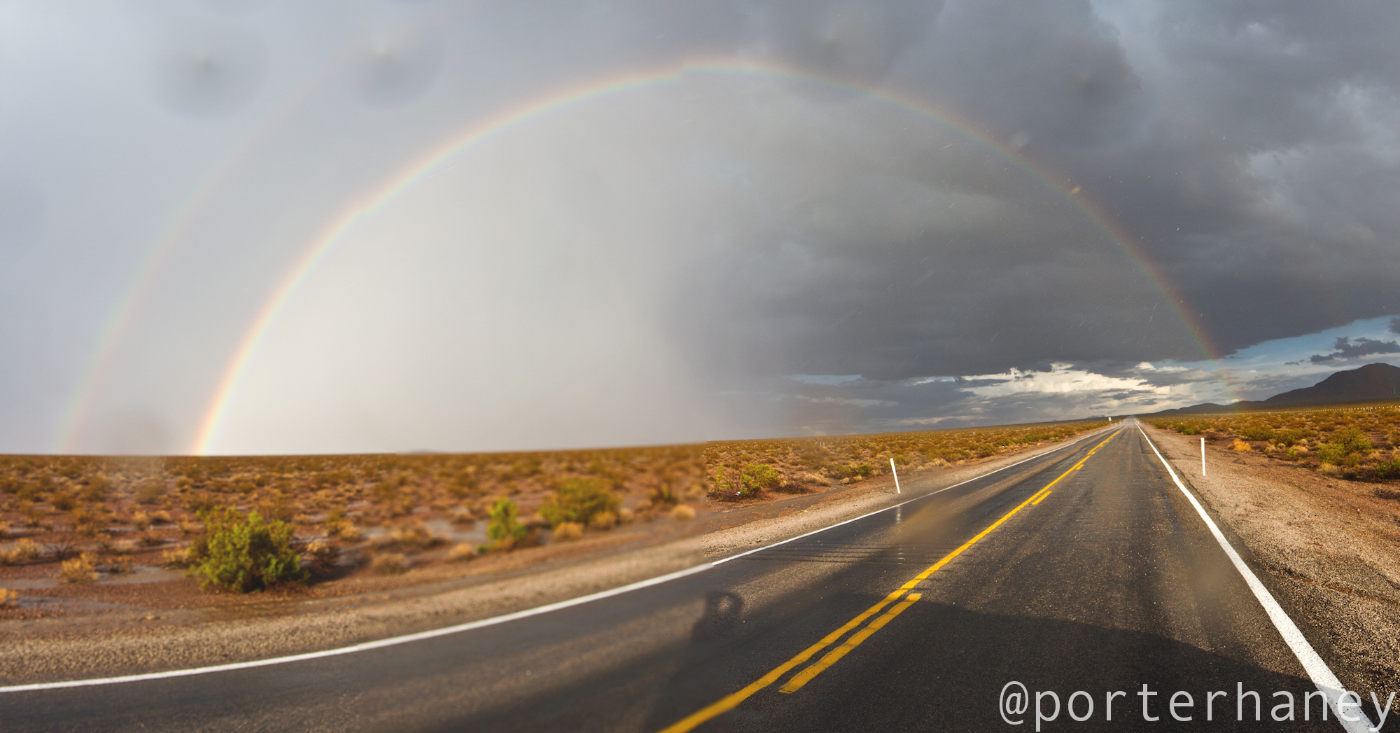
The first evening, just a few miles out of Vegas, I didn’t see any rain, but I did see a rainbow. What could have been a masterpiece turned out to be just a smudged lens and some drops of water resulting in the haziest, misaligned, and generally unfocused rainbow shot I’ve ever taken. However, it gave me hope that they’re might be some big storms over the next ridge.
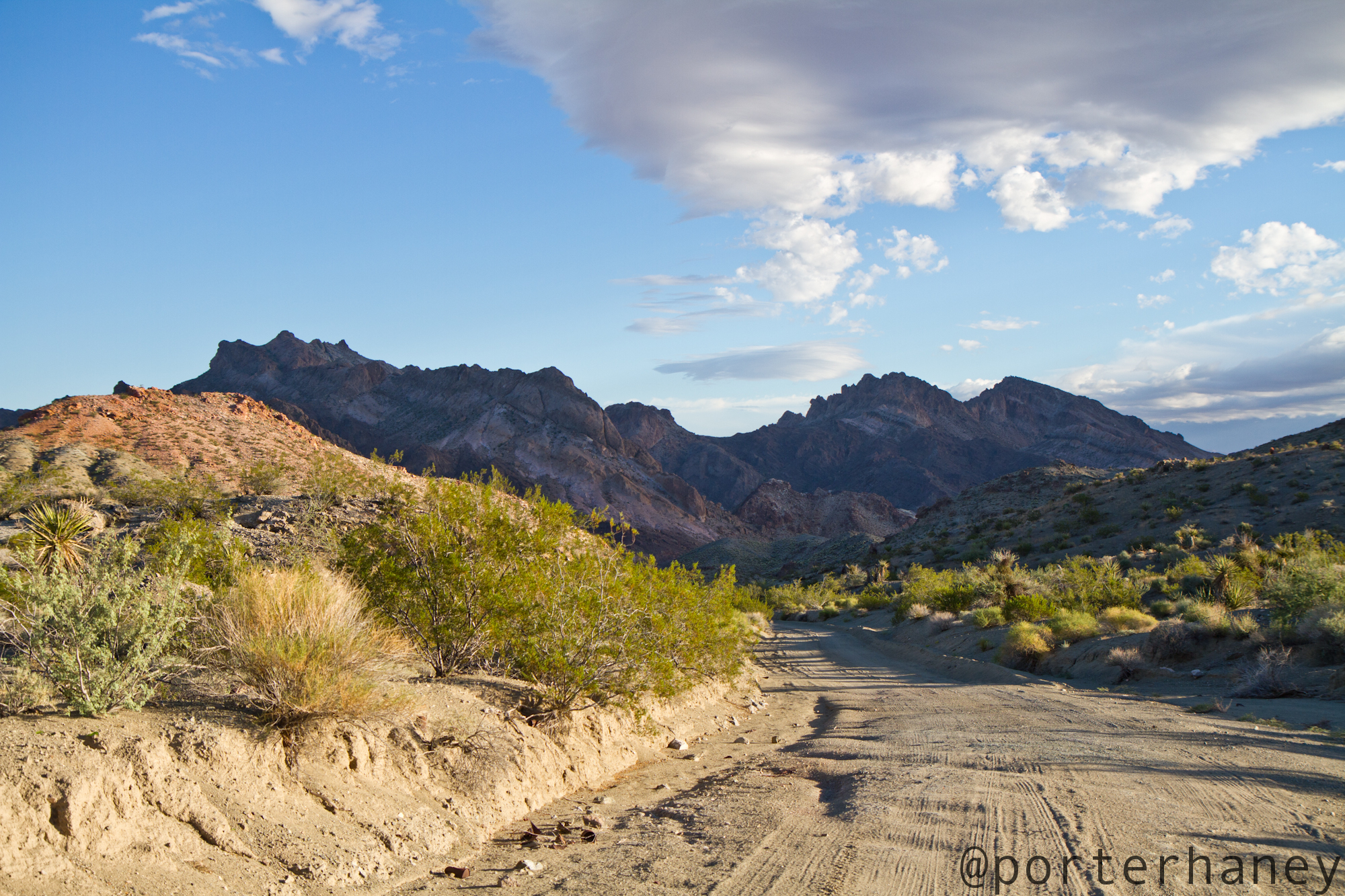
So I went over the next ridge, and the next one, and the one after that too. Eventually, I reached an impassible barrier, at least without pontoons or a bridge. Knowing that I didn’t have much daylight left, I scampered down a long dirt track and off to one of the better campsites in Southern Nevada below the hoover damn.
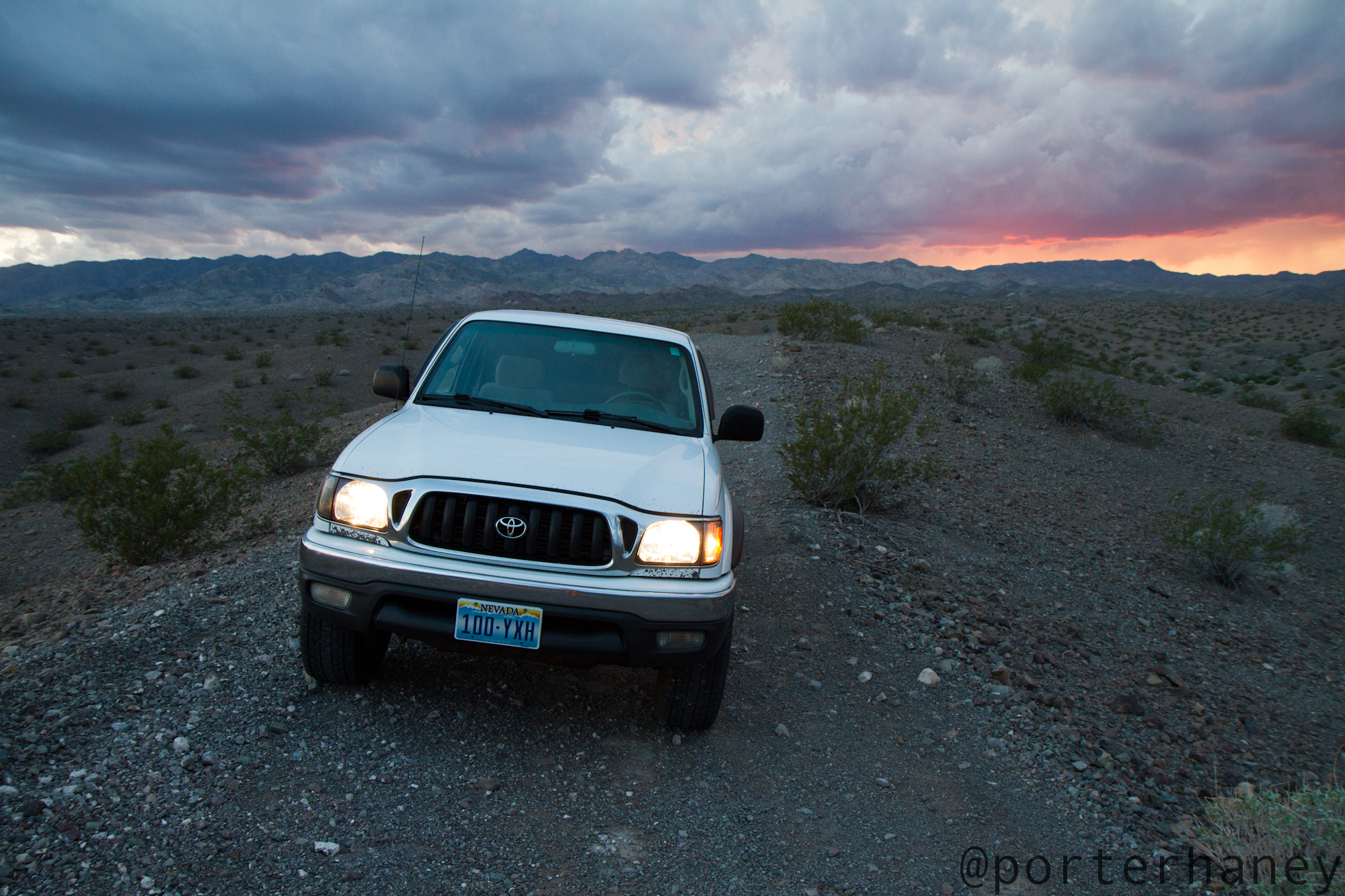
I set up the site, which really just means I pulled a lawn chair out of the truck and proceeded to have a 4 course meal. 3 beers and a sandwich. This edge of the water site didn’t disappoint and I was treated to an amazing storm shrouded sunset, at the end of a dead end road, without another camper in sight while looking up river towards Lake Mead and Boulder City.
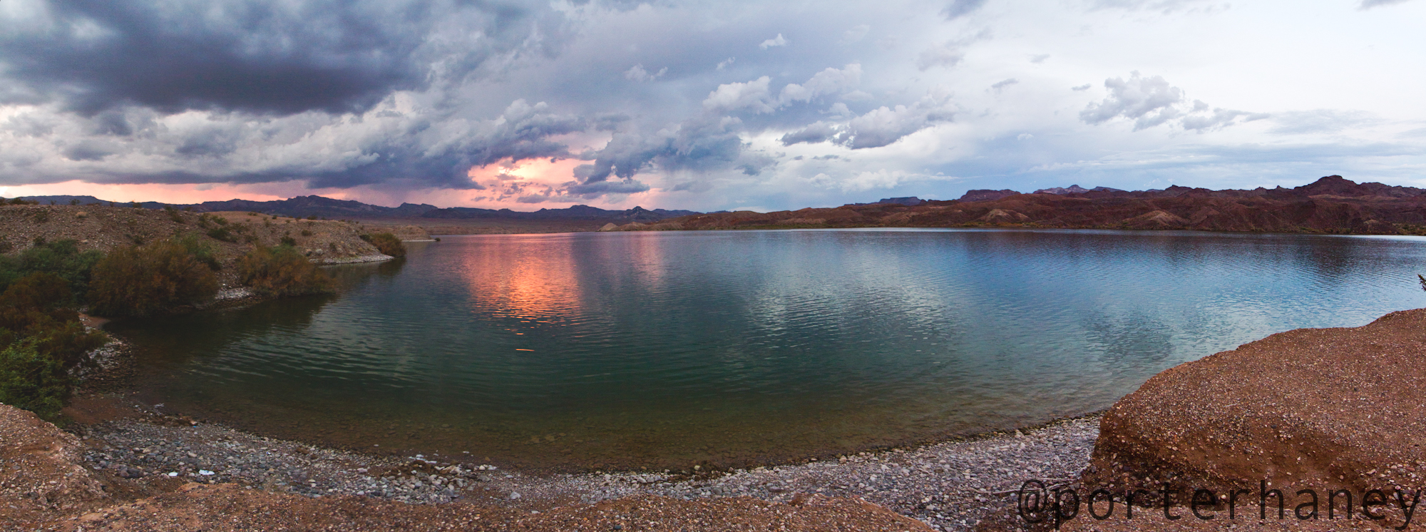
All night thunder boomed around the truck and lightning flashed in the distance, but while threatening this cove it never did actually come over head. I woke up with sunrise and realized I’d been shut out of another round of storms! Damn it. I should have just stayed home, as the messages on my phone showed that Las Vegas had been pulverized by storms all night.
On the drive out the sun started lighting up the valley I was in, and I realized there were still quite a few storms off to the East. A quick (70 mile) drive down to Kingman, Arizona would get me back in the thick of things. I filled the truck with gas and myself with coffee, turned the Guardians of the Galaxy playlist to 11 and hit the road. I was fast approaching the right spot, the mobile radar was lighting up with Emergency Alerts and giant thunderboomers to my east.
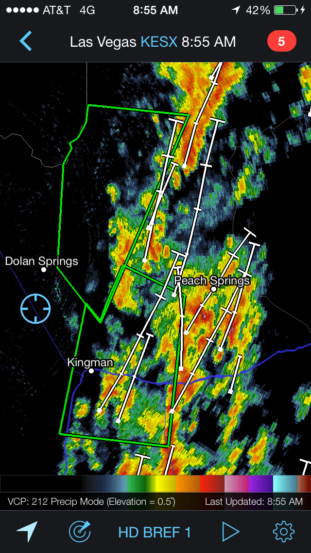
Kingman came and went on the highway with no storm action, and soon I was on historic Route 66 on my way to Peach Springs and the Hualapi reservation. Finally, FINALLY, I was getting some desert Thunderstorm action. And, it didn’t disappoint. Flooded rivers (read: normally dry washes), lightning crashing down, swirling clouds, loud music. Just the party with mother nature that I was looking for.
By this point I was long overdue on my trip and the logical thing would have been to return to Las Vegas the way I’d come. If I turned around now I’d be back in time for a hangout with the Jacobson’s and some yard long margaritas. But with Radarscope open on my phone, I noticed these cells had their sights set on some serious sites. In particular the Grand Canyon and Monument Valley. A detail not lost on me in chasing this storm, is that much of the Grand Canyon and all of Monument Valley aren’t even within modern Doppler Radar – meaning I’d be chasing these storms blind. Or more accurately, the old fashioned way. The way god? intended. By looking up at the sky and using some intuition. Chasing by feel, chasing by luck, and when that doesn’t work chasing some more.
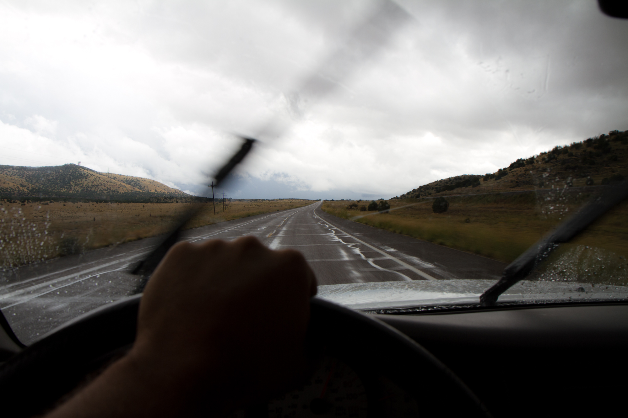
A jaunt through some national forests in central Arizona and I turned North headed for Grand Canyon National Park, the South Rim to be exact. On my way, I finally got out in front of the storms. Instead of chasing dark clouds, they were chasing me. It felt oddly rejuvenating and a little bit scary at the same time.
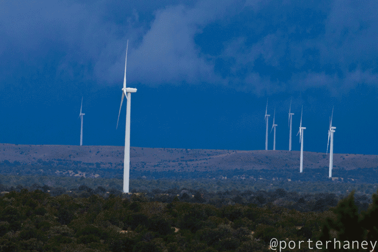
I happened across a large wind farm on this portion of my drive. I’m still not sure why we call it a farm, as we don’t plant the things, and they certainly don’t grow after they’re installed. Maybe it’s because we’re harvesting the wind? But we’re really not harvesting it at all, we’re just using it to turn a blade in a circle. But then again, why do we call all of the other electricity generating things power plants? They aren’t growing anything at all. They’re just turning one form of energy, into another form. Upon seeing the future, or more aptly just a smarter way to generate electricity, it reminded me of the stark difference between burning coal to make electricity and letting blades spin in the win. I know what I’d pick, but I’ll let you decide for yourself.
I know you all just want to scroll down and see the nice picture of the lightning, but tough luck.
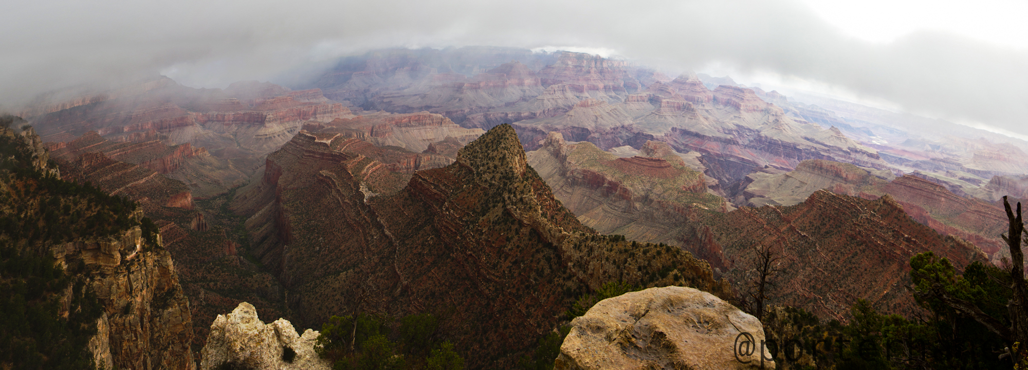
My drive continued north towards the Grand Canyon. As I pulled up to the welcome gate, the line was unusually long, especially considering the sky was releasing a torrent of water and by all accounts it was an awful day to experience the famed natural attraction. When I reached the poor park ranger handing out maps and checking passes, he told me it was a “free” day for “National Public Lands Day” which happens to be September 27th – perplexing, but I can’t argue with free. It turns out National Public Lands Day is an initiative to let people into parks for free in the hopes that they’ll volunteer to pick up some garbage, or save some endangered species, or get rid of invasive plants.
The only invasive plant I saw while I was roaming around the Grand Canyon were the tourists themselves. The place was over run with them. There wasn’t a parking spot to be found that wasn’t full of tourists taking pictures of their windshields. I drove a dozen miles to so and finally found a turn out that wasn’t over run and went out on a spire overlooking the Canyon to get the full effect of the storm.
A blustery, cloudy, downright cold wind was afoot moving clouds up and over the rim of the Canyon.
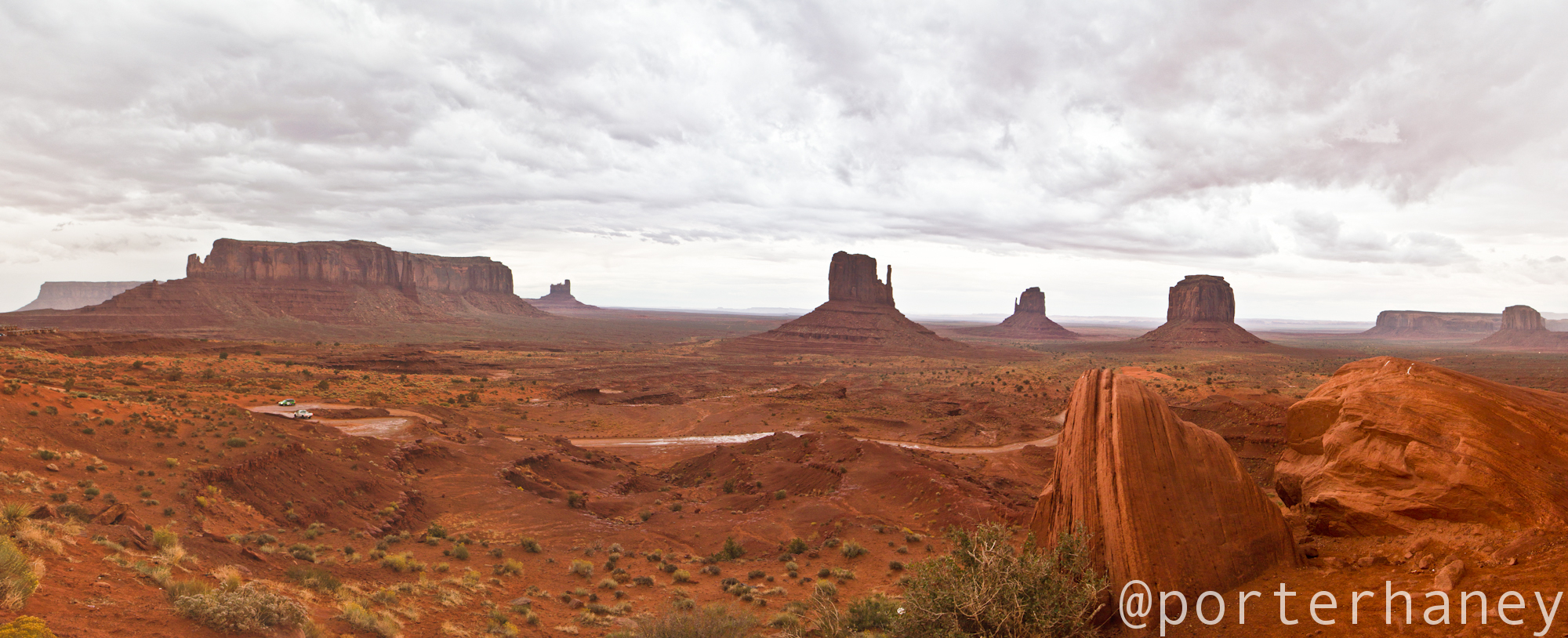
That was enough of the tourists for me, so I hit the highway, and rolled the remaining 150 miles out to Monument Valley through Cameron, and Tuba City, and Kayenta which are a series of Indian towns on the Reservation. This part of the drive, along with next morning’s drive to Page, Arizona was my favorite of the whole trip. Traversing the Reservations 100s of miles at a time you realize just how vast the American west is and how little of it has actually been disturbed by people. Thankfully, there are still lots of wild places, ready and waiting to become the canvas for the next adventurous person.
Monument Valley is actually a Navajo Tribal Park – which is like a National Park, but on Reservation land. The National Park system really has it’s ups and downs, and I’ve talked about that at length before. The most irksome thing is their massive investment in buildings and visitors centers and educational centers and general non-natural bullshit. I was very refreshed to see that Monument Valley didn’t have any of this crap. It did have a hotel with a restaurant and a barebones campground, but other than that, it was very much dirt roads and leave it to nature kind of attitude. This is how I think all parks should be.
I arrived at the park at just about dusk. They had a fantastic little campground on top of the ridge at a place called “The View.” Not knowing what the rules were on the Reservation about sleeping in what look like public lands, and noticing what a good perch they’d located the campground on, I elected to stay there. I got a few pictures or the valley and proceeded to grab some dinner and a few beers by the truck.
After a few hours, the sun went down, and the laser light show came on. The storm had finally caught up to me, and to Monument Valley and was primed to put on a serious show. Heading the roar of the thunder echoing around this valley filled with sounding boards was an entirely new experience. It was comparable to listening to a song with only the bass turned up. The storms spread out across the valley and I decide it was time to capture the action.
I was fortunate enough to have a cooler full of beer, some weird international companions camping near me who also liked Coors, and a nearly unlimited amount of lightning bolts to practice with. I finally honed in on the proper settings and as if by magic the perfect strike happened in front of me.
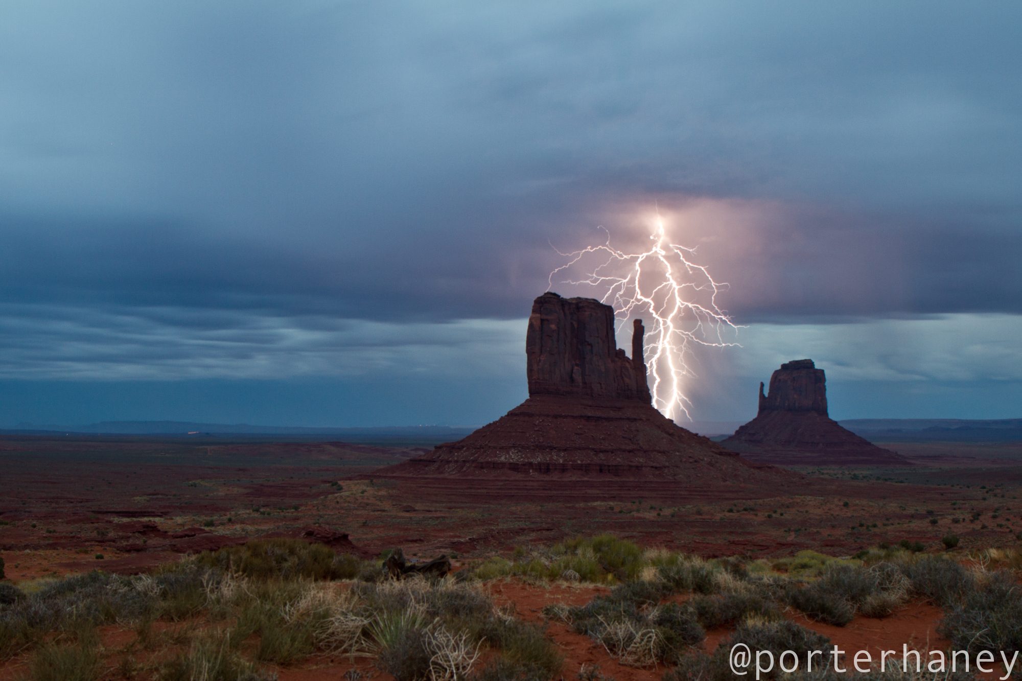
Holy shit. Let me tell you something for a bit here. This picture was really gratifying. Here I’d driven halfway across the desert Southwest in under 24 hours looking for a storm that had yet to really materialize, and I just got a seriously good shot of this thunderstorm. I’d like to say I didn’t overflow with enthusiasm, but I did. Myself and my assembly of international campers proceeded to have an Original Banquet Beer celebration right on the rim of Monument Valley. Who knew a blurry picture on a DSLR screen could be cause for so much celebration?
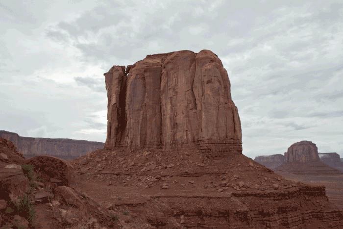
It proceeded to start raining, and continued to rain all night. By dawn it was still sprinkling, but not enough to keep my hopes down for a fantastic sunrise. I drove the rough, washboarded road down into the valley, and out to one of the farthest lookouts, so I could see East. As I got out there sunrise came and went, but nothing of consequence materialized. A nice morning and a nice place for a cup of coffee but all I got was moving clouds and spires.
While the drive back to Las Vegas through the true Arizona Strip was a lot less eventful, it was no less beautiful. The Navajo Reservation, Lake Powell and the Vermillion Cliffs provided a serene and wonderful drive back. I’m sure the Monkey Wrench Gang would have scoffed at my ability to cross that vast amount of terrain in mere hours, but it gave me some solace knowing these incredible swaths of land are just a stones throw from where I live. Well, maybe a big throw, but they’re out there, just waiting to be explored and adventured.
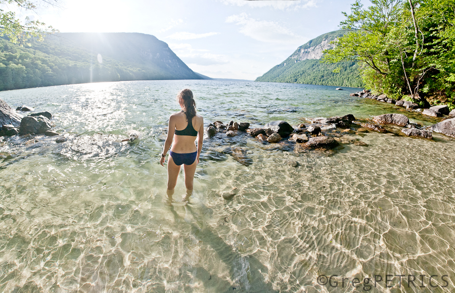
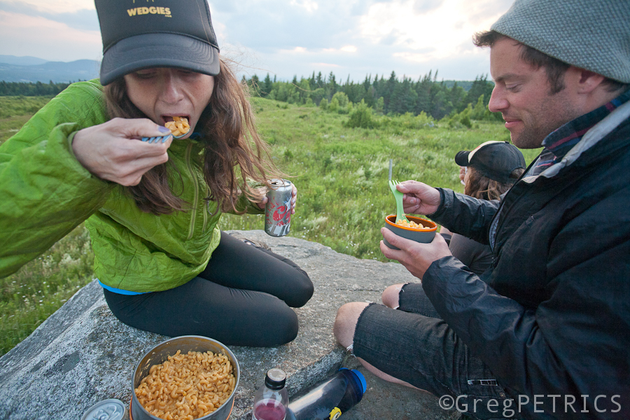
I want to tell you a story about getting lucky.![]() A youngin’ woke up early one morning to compare the new iFauxn sex models. Do they get the one bigger than a PopTart, or smaller?
A youngin’ woke up early one morning to compare the new iFauxn sex models. Do they get the one bigger than a PopTart, or smaller?

Do they get 64 giga bytes or 16? They spent all day worrying about the decision. After reading all the blogz and fanzines and newz feedz, they decided. So happy, so excited youngin’ was. They went to order it.
Computer says: “Must have primary account holder’s SSN to verify account.”
OK Computer. No problem. A few hours later, that’s all set. Now it’s time to spend those 299 dollars, and get this thing. But wait.

Special one time fee of 40 more dollars. Oh well. Whatever. NBD. Click buy.
Computer says: “We automatically ship to primary account holder’s address. It is a PO Box. We cannot ship to PO Box. Good bye.”

Just one more try. This time on ATT.rage instead of Apple.calm.
Youngin’s best pal: “But there’s going to be a glorious sunset. And northern lights. Let’s go and drink a beer and eat some food and enjoy! You can do that later.”
Youngin: “But I won’t get the iFauxn sex FIRST. GRRrrrRRR!”
Youngin’s best pal: “Well I’m leaving.”
Youngin: “Don’t rush me! I have to do this now, or…”
Youngin’s best pal leaves. Youngin angrily chases after. No iFauxn sex today. Or this month probably.
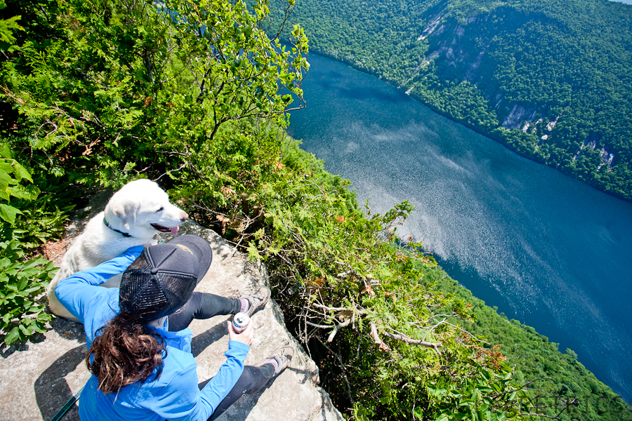
They’re hiking through the fog now. There’s no chance for a sunset, and probably no aurora either with all these clouds. Everyone’s grumpy. No iFauxn. No sunset. No aurora.
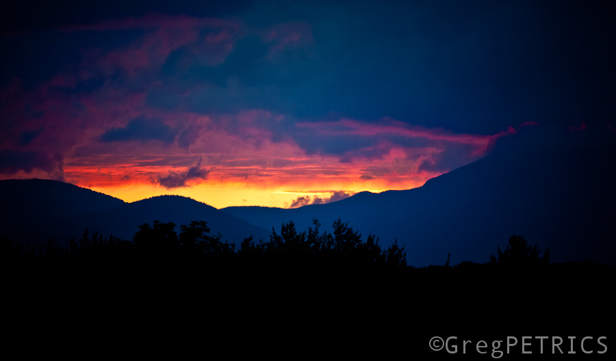
Then it gets a little lighter and less cloudy. And then a little lighter still. And then they’re on top. No iFauxn sex. No problem. Just this:
And then darkness came, and the northern lights flared up.
Brighter and brighter…
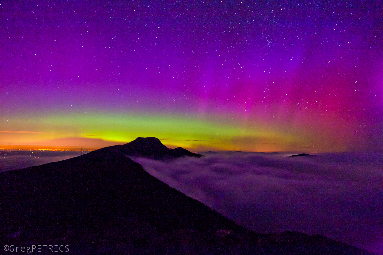
…and brighter.
And then they faded just in time for bed.
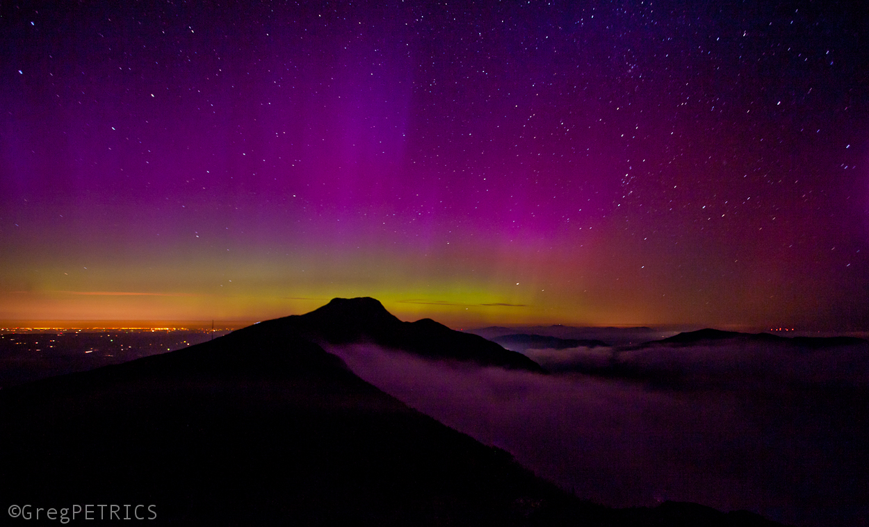
Then the sun came up, and lit up everything again.
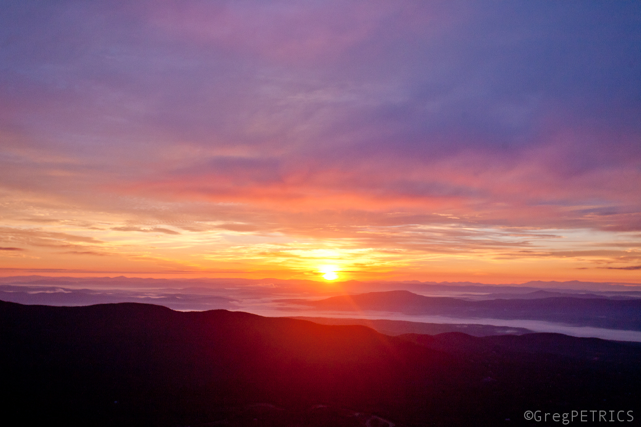
Youngin and friend walked down happy as could be. They got lucky. They realized before it was too late what really matters.
Prints of the aurora photo are available here.
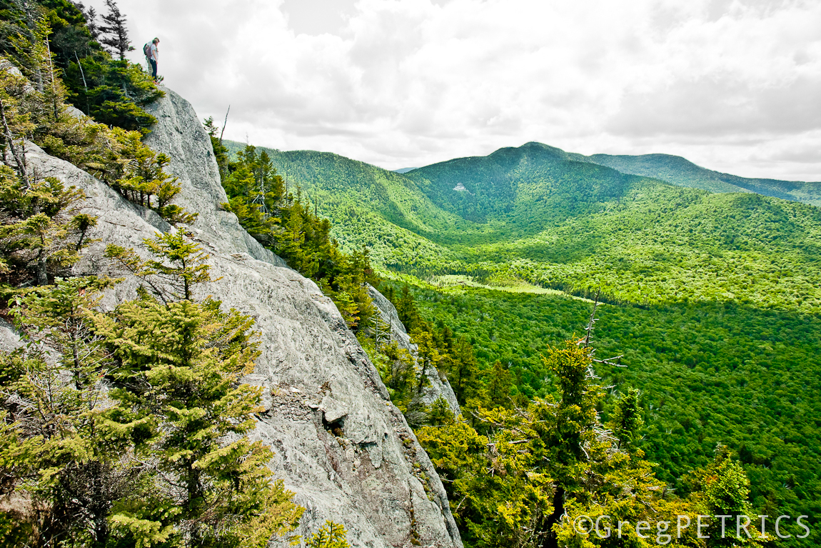
The Pinnacle Butt-Rest
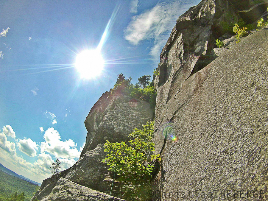
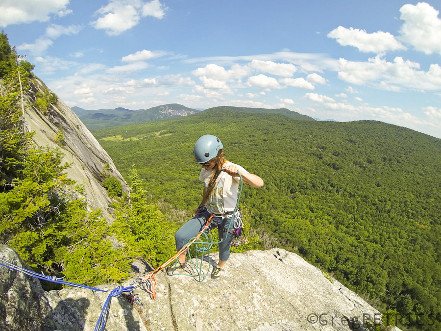
On the eastern flank of Mount Washington, NH, not far from where we like to ski, is an exceptionally nice place to rest one’s butt; the “Pinnacle butt-rest” one might say.
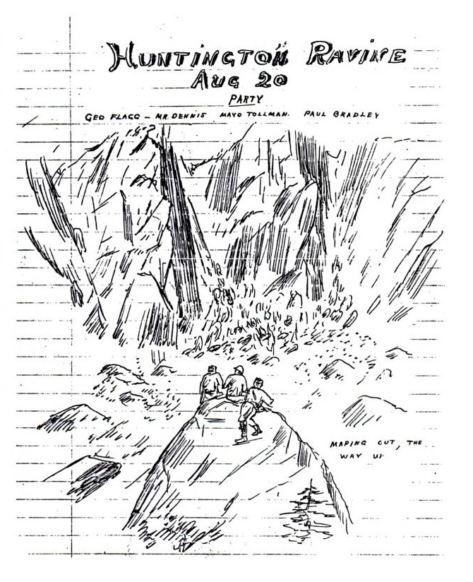
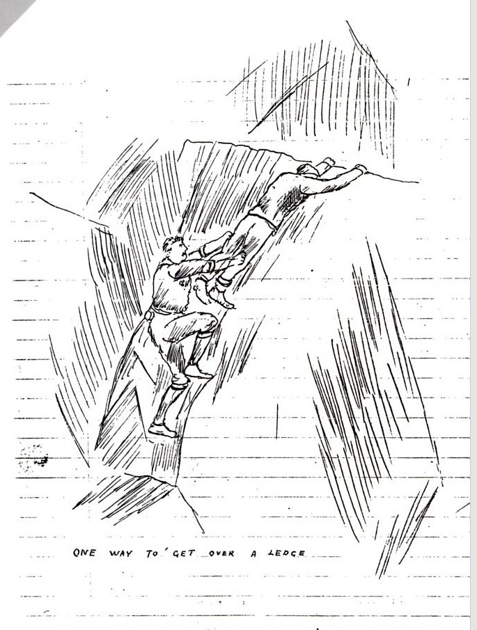
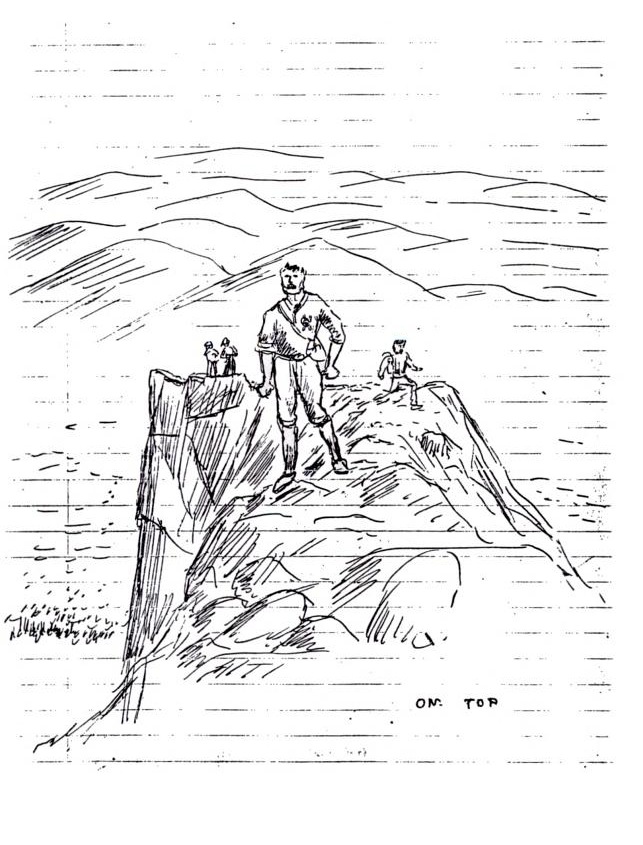
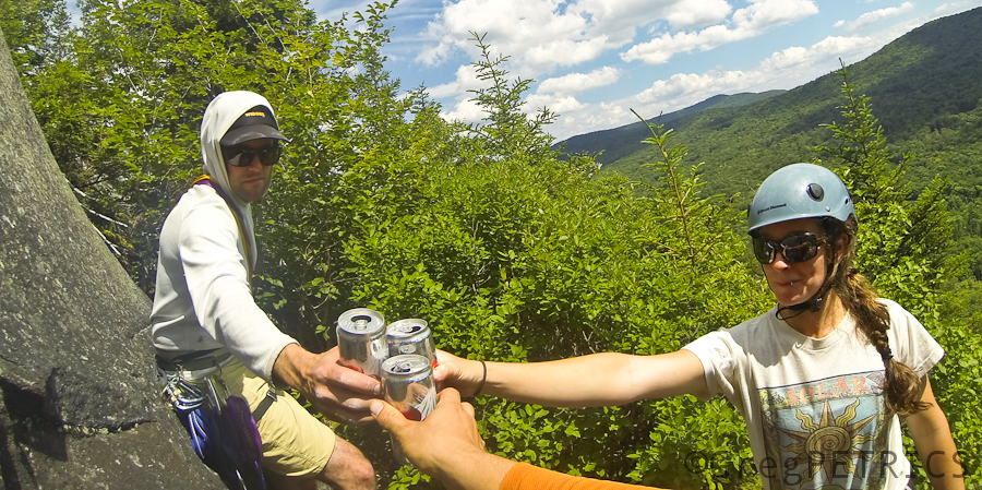
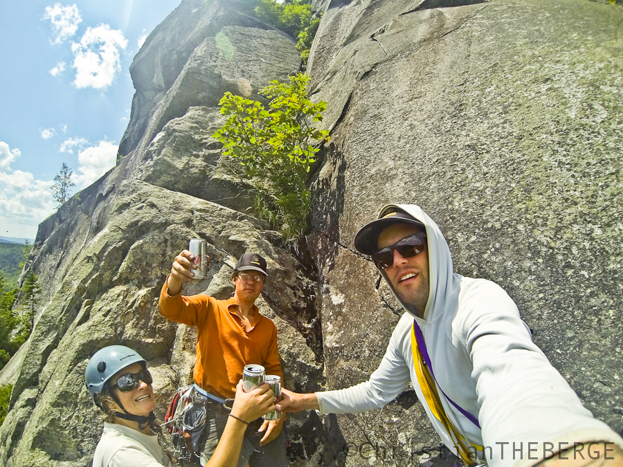
For many years, mountain-folks have widely agreed it’s a great place to rest your butt, but in a seeming-contradiction to Nature’s propensity to minimize everything via paths of least resistance, even though one can drive up Mount Washington, and comfortably stroll down to the top of the Pinnacle butt-rest with a cooler of Coors and backpack of smoked meats, since at least 1910, people have been trying to find harder and harder ways to get to this incredible butt rest. As early as August of 1910, fine folks like Mr. George Flagg and his friends were interested in resting their butt here, but only after going through great difficulty to get to the butt-rest from directly below. Here’s a sketch Mr. Flagg drew of he and his friends admiring the butt-rest from the bottom. The butt-rest is just under the “Mr.” in “Mr. Dennis.” You can almost sense the mile-high stoke-level of these guys in this sketch. But yet it makes no sense. They can just walk around the Pinnacle to get to the top and rest their butts. But they won’t. And we won’t. Mountain-folks all want to go straight up as best they can.
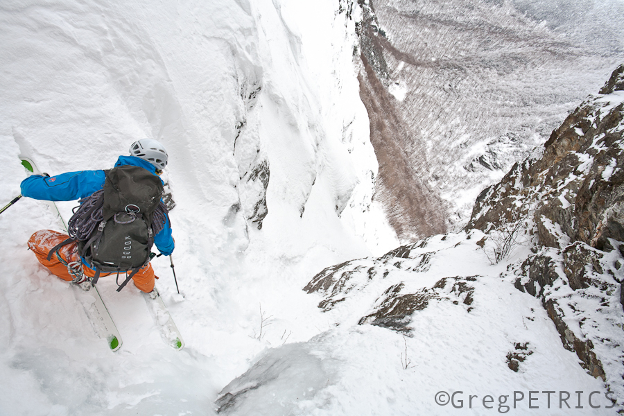
Mr. Flagg and friends–like me and my friend Christian–didn’t know much about ascending the butt-rest from below, but they knew they had to get there from the bottom one way or another. Sometimes they needed to pull on their gear:
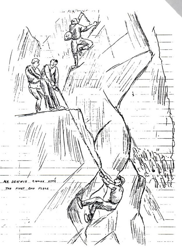
Sometimes they needed to pull on their… friends?
But for some strange reason, even though its wildly beautiful, and perched out in the middle of the rugged Huntington Ravine, actually sitting atop the butt-rest is not enough for humans like me, Christian or Mr. Flagg. We seem to find getting to the butt-rest via the most difficult route we can muster more than half the fun. Look at Mr. Flagg’s beautiful sketch of the Pinnacle butt-rest. It makes no sense why he didn’t just want to walk around. Or maybe it does.
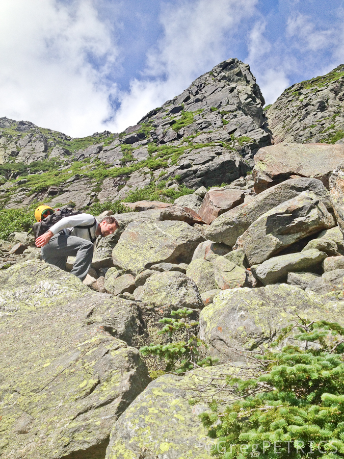
Of interest, the violations of Nature didn’t end with Mr. Flagg. For instance in October of 1928, William P. Allis along with some of his friends approached the butt-rest from a route through a “chimney” that a previous party, led by Mr. Lincoln O’Brien in May of 1927, had warned was unclimbable. So not only were they looking for a more challenging route to the butt-rest than Mr. Flagg’s, but moreover they had been warned of their chosen route’s impossibility! Of course Mr. Allis found a way up it however. He’s a human being. By standing on someone’s shoulders, and then using nearly-forgotten-abilities he had honed as a boy climbing trees, Mr. Allis wiggled up through the chimney, and then on up towards the butt-rest. If his technique was anything like ours, his motions were no doubt lewd and lascivious. Today mountain-folk call this place the “Allis Chimney” in honor of Mr. Allis’ brave yet ultimately worthless wanton wiggle. Here’s an old picture of a party (not Allis’) climbing directly below the chimney:

Of course it didn’t end with Mr. Allis. Indeed, Robert Underhill (perhaps the father of American rock climbing, and who was following behind Mr. Allis in October 1928) wrote in his notes detailing that first ascent, that to the right of Allis’ chimney “the wall is unclimbable.” Today that “unclimbable” wall is the most popular route to the butt-rest, and sadly most folks skip Mr. Allis’ celebrated chimney. Go figure. We humans are strange creatures.
Considering the history of strife surrounding this Pinnacle butt-rest, and having ticked off a few warmup climbs in Vermont, about 104 years after Mr. Flagg, my friend Christian and I decided it was time to go rest our butts atop the Pinnacle too. We decided to approach from Pinkham Notch. Here’s our first view of the Pinnacle (cf. Mr. Flagg’s sketch above).
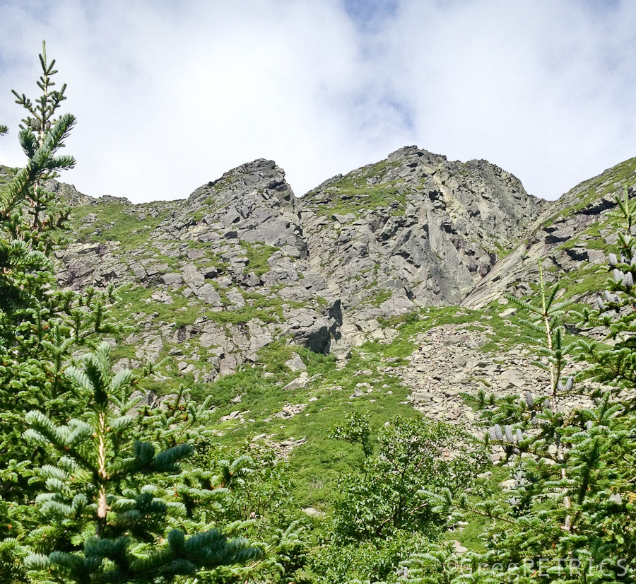
As is often the case with us, upon finally seeing the thing we came to climb, we both agreed that it looked a lot less scary on the Internet.
No Vermonters in Heaven
I dreamed that I went to the city of Gold,
To Heaven resplendent and fair.
And after I entered that beautiful fold
By one in authority there I was told
That not a Vermonter was there.
“Impossible, sir, for from my own town
Many sought this delectable place,
And each must be there with harp or a crown,
And a conqueror’s palm and a clean linen gown,
Received through a merited grace.”
The Angel replied: “All Vermonters come here
When they first depart from the earth,
But after a day, or a month, or a year
They restless and homesick and lonesome appear,
And sigh for the land of their birth.
“They tell of ravines, wild, secluded and deep
And of flower-decked landscapes serene;
Of towering mountains, imposing and steep,
A-down which the torrents exultingly leap,
Through forests perennially green.
“They tell of the many and beautiful hills,
Their forests majestic appear,
They tell of its rivers, its lakes, streams and rills,
Where nature, the purest of waters distills,
And they soon get dissatisfied here.
We give them the best the Kingdom provides;
They have everything here that they want,
But not a Vermonter in Heaven abides;
A very brief period here he resides,
Then hikes his way back to Vermont.”
–Dr. E. F. Johnstone 1915

-
Search
New Comments
macbook repair seattle said: “macbook repair seattle Let’s get it started...(read more)” about Let’s get it started
Greg said: “Thanks for all this great info. And...(read more)” about Skiing Mt. Colden’s Trap Dike
Greg said: “Definitely late, but always welcome!” about Skiing Mt. Colden’s Trap Dike
Bob said: “[* Shield Security plugin marked this comment...(read more)” about Skiing Mt. Colden’s Trap Dike
Regular paint Maintenance said: “Regular paint Maintenance Behind The Schuss(ic) :...(read more)” about Behind The Schuss(ic)
The 2012-13 Ski Season in Photos #13 | NY Ski Blog said: “[…] tweeting about big Memorial Day snow...(read more)” about pow
ml242 said: “LuckyLuc and MadPat on the same day?...(read more)” about Deep Cover Anthropology
Talbert said: “Long time no comment..... But great to...(read more)” about Man of Many Moods
Twitter Feed
-
Categories
- Skiing (438)
- Weather (188)
- WTF (5)
- Quick Update (173)
- Full Trip Report (165)
- WebiGNARs (45)
- General Interest (38)
- Site News (27)
- Summer (59)
- Hiking (26)
- Swimming (15)
- Climbing (13)
- Longboarding (3)
- Whitewater Kayaking (2)
- Mountain Biking (1)
- SPA (16)
- Gear Review (8)
-
Archive
- October 2018
- June 2017
- November 2016
- October 2016
- March 2016
- January 2016
- October 2015
- February 2015
- January 2015
- December 2014
- November 2014
- October 2014
- September 2014
- July 2014
- April 2014
- March 2014
- February 2014
- January 2014
- December 2013
- November 2013
- October 2013
- September 2013
- August 2013
- June 2013
- May 2013
- April 2013
- March 2013
- February 2013
- January 2013
- December 2012
- November 2012
- October 2012
- September 2012
- August 2012
- July 2012
- June 2012
- May 2012
- April 2012
- March 2012
- February 2012
- January 2012
- December 2011
- November 2011
- October 2011
- September 2011
- August 2011
- July 2011
- June 2011
- May 2011
- April 2011
- March 2011
- February 2011
- January 2011
- December 2010
- November 2010
- October 2010
- September 2010
- August 2010
- July 2010
- June 2010
- May 2010
- April 2010
- March 2010
- February 2010
- January 2010
- December 2009
- November 2009
- October 2009
- September 2009
- August 2009
- July 2009
- June 2009
- April 2009
- March 2009
- February 2009
- January 2009
- December 2008
- November 2008
- October 2008
- April 2008
- March 2008
- February 2008
-
Friends of F.I.S.

About Us:
We are a group of powder hungry, east-coast-bred, world-traveling skiers and riders who Earn Our Turns to bring you the best stoke a click-of-the-mouse can buy.We hope our adventures inspire you to Earn Your Turns as well!
LEARN MORE

Latest Weather
When one makes meatballs, one must begin with quality meats: ...
Read more in: Meatballs! (read more)