
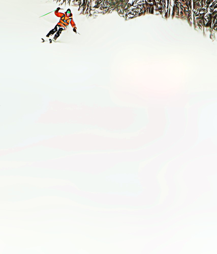
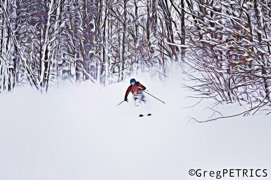
Wingbowl weather forecast (Updated)
“Lionel, you mean Superbowl right?”
No. I don’t. As many of you know I was raised in and around the great (shut up) city of Philadelphia. Twenty-two years ago, in light of the fact that the Philadelphia Eagles would never be in a Super Bowl (or win said Superbowl) and because Philadelphia loves food, the local sports radio station created this little event where fat dudes would eat chicken wings for prizes the friday before the superbowl. They called it “the Wingbowl.” To trump it up they got some local strippers to count the wings that were eaten. It was a gag. It was held in a hotel lobby.
One problem…we loved it. Seriously. What was a gag is now the richest eating competition in the world. It is now held in the hockey stadium where 20,000 tickets sell out in under two hours. More beer is sold during the wingbowl (it’s from 6 to 9 am..doors open at 4:30, beer at 5) than ANY other event at the stadium including concerts. There is procession of “eaters” with floats and a many thousand dollar prize for the best entrance. There are dozens of mostly naked women (wingettes [careful now]) who count wings for their “eaters” and then cavort around and ride a mechanical bull two win a car (or harley). The winning eater not only gets a car but also and a huge diamond ring (like a superbowl ring), and something around twenty thousand dollars cash. To give you a sense of magnitude the record number of chicken wings eaten in 3o minutes is 337 by Kobayashi. The doctor for event..A VET. And there is only one rule, “you heave, you leave.”
#Philly.
Anyway, as you have all decided I’m a sick animal and Philly is a gross place that needs to burn, I’ll turn to the weather for Wingbowl weekend.
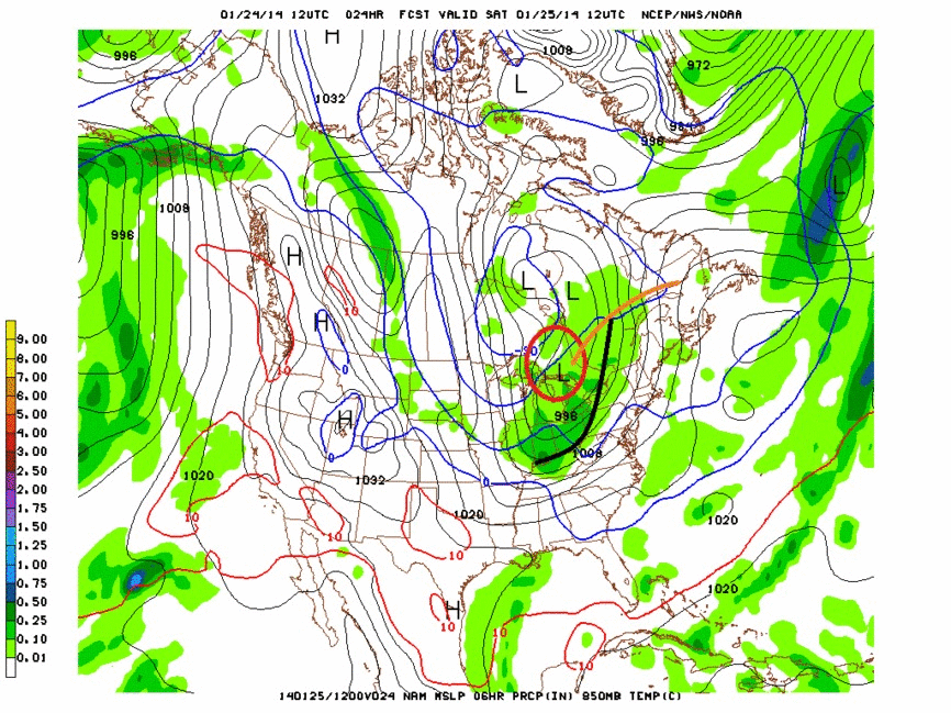
Currently, a weak ridge of high pressure is building over the north country. That ridge of high pressure will slide east Saturday as a low pressure systems moves northeast off to our west. You can see the low in the map below.
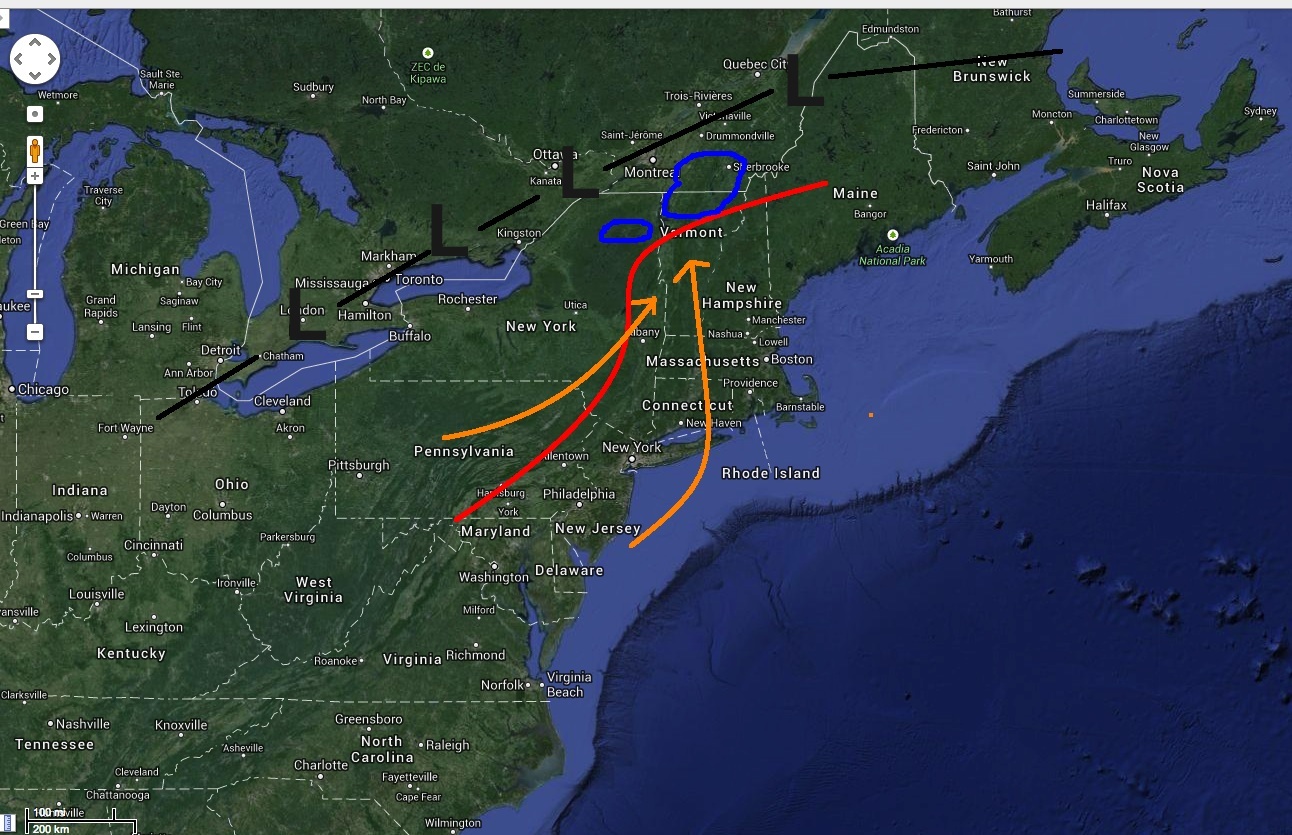
As the low moves north it will push warm air in from the southwest. This warm air advection will push 850mb temps to just about 0c overnight sunday as the precip moves in. I’ve marked in red the consensus extent of the 850mb freezing line. Looks like temps north and west of this line will just stay below 0C — meaning snow. As the warm air moves into the region it will lift and we’ll see some periods of snow just north of the warm front. Looks like right now areas circled in blue on the map will see the best snows. By sunday AM (storm snow moves in from early saturday evening through sunday am) I think these areas will see a general 4-6″ snowfall.
One notable development on the high res models is the potential for heavier snow in the High Peaks.
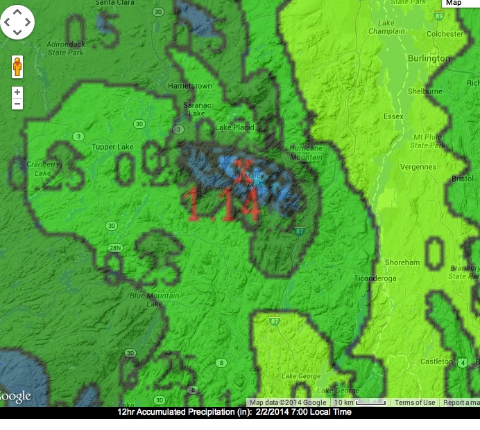
Traditionally, events like this which have a period of precip with south west winds (marked in orange) produce a fair amount of snow in the High Peaks as the HP have a pretty strong orographic profile as approached from the S/W. I’m not sure I see 1.14 inches of water (12″ of snow) but it’s certainly possible that the ADK has the best N/E snow. Oh and don’t sleep on areas north of Jay…like Sutton. The best dynamics for snow (temp and lift) are likely to occur just north of the border. Thus I think Sutton could see maybe 6-10″.
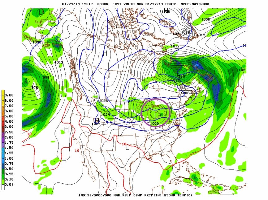
Looking forward there is a lot of talk about a storm midweek next week. Models are certainly fairly consistent that something is going to eject out of the midwest and slide generally east across the country. On the edge of GFS reasonability it certainly looks like a wet 24 hours.
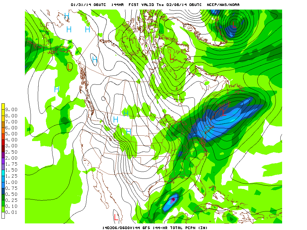
Problem is I don’t buy that this is a real snow maker for the North Country. The upper level pattern is fairly flat. For lows to track into the deep N/E Mtns and wrap-up into strong snow makers the upper level should feature a fairly deep trough with a slightly negative tilt (trough axis aligns NW/SE). That shape causes low pressure systems to track N/W into the center of New England. As you can see below the trough shape isn’t that. It’s flat.
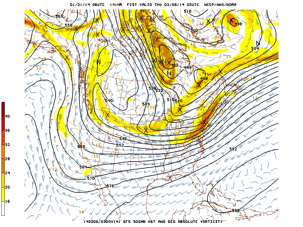
In my mind, this makes it more likely for the low to slide off to our south and east. Not to say that we are unlikely to see 3-6″ …just that it is unlikely we’re talking about a 1-2′ nor’easter out of this event. Of course I could be wrong and the low tracks right through central NY and So. VT and we’re just crushed. I’ll keep you updated.
UPDATE…No need to change my forecast. Storm will track south of our region tonight through tomorrow. Heaviest snow will be in a band crom Northern Mass through southern VT. Heaviest snow totals will be at Killington where 8-12 inches of snow could fall. The Catskills will also do well and could see 8-12 inches of snow.
The pitter-patter of little feet….
Older people tend to say “they hear the pitter-patter” of little feet with affection. Generally I hear the pitter-patter of little feet and think “ugh, germs.” Or “ugh, don’t get my couch dirty…I better move that book so little sloppy face over there doesn’t tear it apart.” (Hint: I don’t like kids). But “little feet” aren’t always so bad.
This weekend I think there is a chance that by mid-next week, we’ll all be enjoying the pitter-patter of a “little foot.”
Here is why.
Tomorrow, a low will swing through the upper great lakes (circled in red). As it moves an attached cold front will push into the region with some strong arctic air (marked in black).
The dynamics of this front certainly support the snow squalls developing along the front sateruday afternoon. Winds will be strong out of the southwest in advance of the front and then shift to the west/northwest as the front passes and low moves off to the east Saturday night into Sunday AM. (Where it will just CRUSH the Gaspe FYI)
The best snow supporting atmospheric dymnaics look to occur between early afternoon Saturday and early sunday morning. The front is a little moisture starved (duh, it’s really dry outside and pwats values are all time low) but the airmass is saturated. Were this front dropping out of the northwest I’d say it would be a solid 6″ producer for the ADK, and Greens…these are the fronts that usually do great for Jay and Smuggs. However – as we’ve seen many times this year, fronts out of the west/southwest just dont’ do as well. The antecedent s/w winds don’t produce orographic snows, and don’t tap into any lake moisture. Also the upslope parameters aren’t awesome with this event (s/w winds, slightly blocked flow…welcome to 2013-14). Certainly this will make some snow but I’m inclined to go a little lower with a 2-4″ forecast.
Next up comes a weak low pressure system riding along a frontal boundary to our south (circled in purple).
This system is essentially a clipper storm, which if dropping in from the west/northwest would again be good for a solid 6″. As it stands again we’ll have to deal with some southwest winds which are NOT orographic and which warm the mid levels of the atmoshere blocking the flow. Regardless I do think we’re in for another 2-4+” Monday into Tuesday.
With some winds between these systems out of the N/W Sunday and early Monday, I think we could also sneak in some light upslope snow showers. Though with really cold temps we’re well below optimal temps for dendritic growth. I could see 1-2″ on N/W winds in these showers.
So overall, I think with a little luck we could be looking at a “little foot” by tuesday morning. Certainly not the dump we need to get everything back in shape but heck, with 6-10″ early this week and another 6 possible, we’re at least on the right track for the season!
Algorithms
It’s a word you’ve probably heard, and dismissed as being too many syllables to understand: “algorithm.” There’s no reason to fear however; you know what an algorithm is. I promise. I’ll just have to show you that you know before you know you know (trust me, I know).
Let’s start with an easy example I know you know you know: The Pow Algorithm.
(Note: in all that follows, the object MBBI is defined as follows.)
function Pow_Algorithm(var_arg_in)

1 IF snow_total_nearby() >= 10
2     find(location(snow_total_nearby()))
3     drive(location(snow_total_nearby()))
4     WHILE group_morale() >= cranky_pants
5         ascend(location(snow_total_nearby()))
6         descend(location(snow_total_nearby()))
7             WHILE pow_in_face()=1
8                 hoot()
9                 hollar()
10                giggle_like_little_kids()
11            END
12        IF num_MBBI() > 0
13            pop_MBBI()
14        END
15    END
16 END

END
As you can see, this algorithm–or program if you will–tells one what to do when powder snow arrives nearby in quantities greater than 10 inches. Of course this is only pseudo-code, and a computer would be hard pressed to run this algorithm (mostly because computers don’t like skiing; in fact they don’t like anything; they have no consciousness [more on that at a later date]).
Another example is the code that your GPS-device writes for you to follow to get you lost when you want to get somewhere. It’s sad really. I’m crying right now thinking about the irony of this algorithm.
But not all algorithms involve tears. Here’s one that we wrote recently, and so I’d be surprised if you are familiar with it. It implements Pow_Algorithm() as a subroutine, so it’s a good third example for beginners. We developed this algorithm last week when Lake Ontario decided to unload its contents on surrounding environs. Here’s the code:
function Ontario_Pow_Hunt(var_arg_in)

1 let_Hutz_drive_angrily_as_friends_fart_in_newly_cleaned_upholstery()
2 drive_toward_pow_with_ThePeter_making_wierd_faces_at_the_smell_of_said_farts()

3 Pow_Algorithm(Day_1, 12_inches, lots_of_energy, only_group_skiing, lots_of_MBBI)
A Glimmer of Nope
In the middle of a whole bucket of nope comes a ray of light; a glimmer of nope… I mean hope.
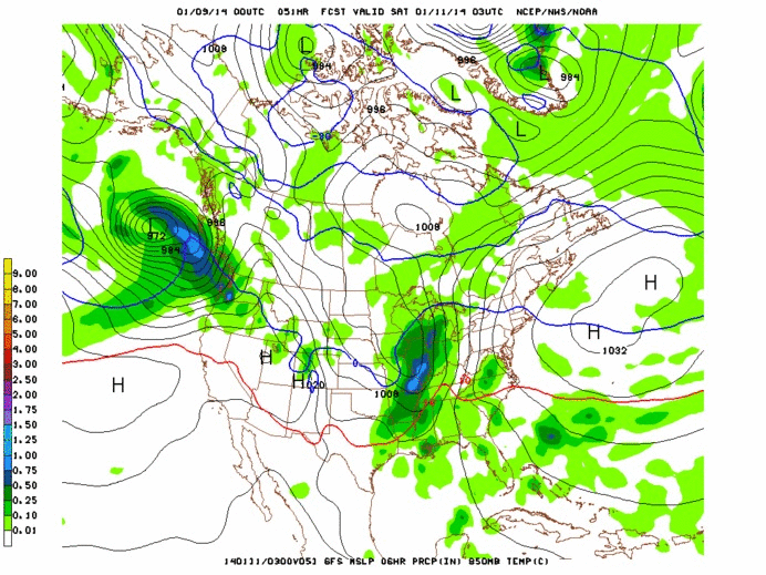
Currently a large low pressure system is sliding through Ontario and will slide northeast through Quebec overnight. I don’t need to tell you that this has resulted in less than stellar weather today. Currently it’s raining with strong southerly winds.
A trailing cold front associated with the parent low will push through the region early tomorrow morning. Unlike the last few fronts, this one will not be a freight-train of dry arctic air. As I said in this post a few days ago, with a more zonal flow setting up for the next few days, this rain event won’t be followed by a harsh blast from the Polar Vortex. Instead of being cold as ice, after the parent low pulls out, at around 7 am on Sunday, temps should be about 0C at 1500ft and -8c across the summits.
At the same time, a fair amount of moisture will be spun in from the flow around the parent low.
Looking at the basic upslope parameters indicates that a period of decent upslope snow is possible from 12z (7am) through 00Z(7pm) tomorrow in the northern Greens.
We have good low level saturation of the airmass:
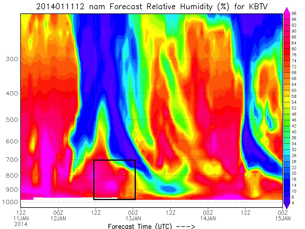
At the same time winds are predicted to come from the 270-290 range….which is pretty much ideal for orographic uplift along the greens:
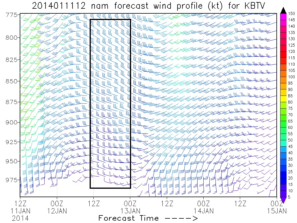
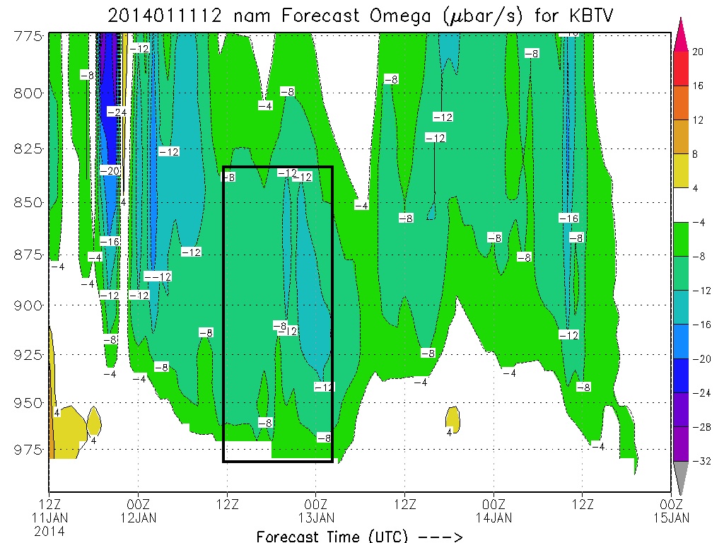
This results is sufficient uplift in the critical 900mb to 850mb layer:
As a result, models are putting out a fairly robust total QPF for the period up by Jay.
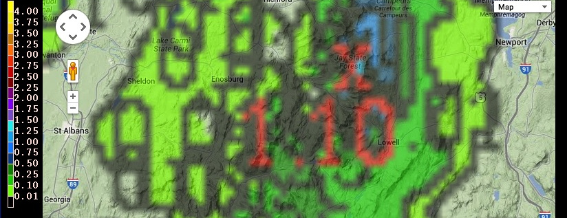
That 1.10″ is MELTED liquid mind you… not total snowfall. Hopefully I don’t need to tell you that 1.10″ of liquid can make a lot of snow!
Now now chaps and chappetes, let us not blow our load too much here. Two things bother me.
1) The atmosphere at 700mb never really reaches the critical saturation level of 70%. It is progged to get close. High 60s%. Which is enough for some upslope snow to develop. But the system REALLY cranks when we get that mid level air saturated above 70%. At drier levels, rising air tends to dry out and snow amounts get cut down as dendritic growth is cut down.
2) The Froude number is a progged at a very robust 1.86 and 2.04 for a period tomorrow per the experimental models run by NWSBTV. Numbers that high indicate that the flow over the spine could be unblocked. We need some blocking of the flow to create the cycle of rising air that makes upslope snow. Unblocked flows tend to make for flurries as opposed to big pows. Now, I think the numbers are a bit high. I don’t see the ripping winds that are normally associated with unblocked flows at 850mb.
With those two issues addressed, I wouldn’t bat an eye at 4-6″ along the northern Green Mountains with pockets of 10 possible up at Jay Peak which is closest to the moisture, has the best chance at being coldest, and is the best at providing a block (to counteract the high Froude number).
So lets watch and see what happens!
Nope, nope, nope.
“Lionel, why haven’t you posted a full write up in a while? Do you not love us?”
No. I still love you. The weather doesn’t.
For the Northern Mountains of New York, Vermont and New Hampshire, the last month has been about as grim as grim can be. Dry deep freezes punctuated with ice and rain storms does not make for really good conditions. While there have been a few good days sprinkled in, by and large it’s been a sad trombone state of affairs.
Good news is the pattern looks like it is changing. The bad news is that first we get ANOTHER RAINSTORM.
Yep:
On Saturday a low pressure center will deepen in the south, ride up the west of the Appalachian spine and bring warm temps and possible periods of heavy rain to the Northeast. (Maybe it will melt some of the ice at least? I’m fairly tired of worrying about breaking a bone walking to my car.)
After that, there is fairly good indication that the pattern becomes more “zonal” for a period of time. That means a fairly straight west to east flow with temperatures at or slightly above normal. Storms tend to be less impressive in these pattens with elevation dependent snowfalls. However, that’s better than deeply amplified storms that cut to our west due to blocking patterns.
So stay tuned, sharpen the edges and make do with what we got. At some point it will be “on.”

-
Search
New Comments
macbook repair seattle said: “macbook repair seattle Let’s get it started...(read more)” about Let’s get it started
Greg said: “Thanks for all this great info. And...(read more)” about Skiing Mt. Colden’s Trap Dike
Greg said: “Definitely late, but always welcome!” about Skiing Mt. Colden’s Trap Dike
Bob said: “[* Shield Security plugin marked this comment...(read more)” about Skiing Mt. Colden’s Trap Dike
Regular paint Maintenance said: “Regular paint Maintenance Behind The Schuss(ic) :...(read more)” about Behind The Schuss(ic)
The 2012-13 Ski Season in Photos #13 | NY Ski Blog said: “[…] tweeting about big Memorial Day snow...(read more)” about pow
ml242 said: “LuckyLuc and MadPat on the same day?...(read more)” about Deep Cover Anthropology
Talbert said: “Long time no comment..... But great to...(read more)” about Man of Many Moods
Twitter Feed
-
Categories
- Skiing (438)
- Weather (188)
- WTF (5)
- Quick Update (173)
- Full Trip Report (165)
- WebiGNARs (45)
- General Interest (38)
- Site News (27)
- Summer (59)
- Hiking (26)
- Swimming (15)
- Climbing (13)
- Longboarding (3)
- Whitewater Kayaking (2)
- Mountain Biking (1)
- SPA (16)
- Gear Review (8)
-
Archive
- October 2018
- June 2017
- November 2016
- October 2016
- March 2016
- January 2016
- October 2015
- February 2015
- January 2015
- December 2014
- November 2014
- October 2014
- September 2014
- July 2014
- April 2014
- March 2014
- February 2014
- January 2014
- December 2013
- November 2013
- October 2013
- September 2013
- August 2013
- June 2013
- May 2013
- April 2013
- March 2013
- February 2013
- January 2013
- December 2012
- November 2012
- October 2012
- September 2012
- August 2012
- July 2012
- June 2012
- May 2012
- April 2012
- March 2012
- February 2012
- January 2012
- December 2011
- November 2011
- October 2011
- September 2011
- August 2011
- July 2011
- June 2011
- May 2011
- April 2011
- March 2011
- February 2011
- January 2011
- December 2010
- November 2010
- October 2010
- September 2010
- August 2010
- July 2010
- June 2010
- May 2010
- April 2010
- March 2010
- February 2010
- January 2010
- December 2009
- November 2009
- October 2009
- September 2009
- August 2009
- July 2009
- June 2009
- April 2009
- March 2009
- February 2009
- January 2009
- December 2008
- November 2008
- October 2008
- April 2008
- March 2008
- February 2008
-
Friends of F.I.S.

About Us:
We are a group of powder hungry, east-coast-bred, world-traveling skiers and riders who Earn Our Turns to bring you the best stoke a click-of-the-mouse can buy.We hope our adventures inspire you to Earn Your Turns as well!
LEARN MORE

Latest Weather
When one makes meatballs, one must begin with quality meats: ...
Read more in: Meatballs! (read more)