
TOTALS THROUGH TUESDAY:
I told you FEETS:

Sorry Cottonwood peeps. I haven’t been rejecting you. Just with all the silly messy snowy and active weather on the East Coast it’s been hard to turn my attention elsewhere. But with a cold high pressure and light snow snowers settled into the East Coast for the rest of the week (until Sunday night when we have to look at potential coastal storm impacts) I have time to discuss the ‘Satch’s next snow event.
As one system exists towards the southeast a weak ridge of high pressure will build in briefly. However, by friday elements of a large western storm will be moving into the region.
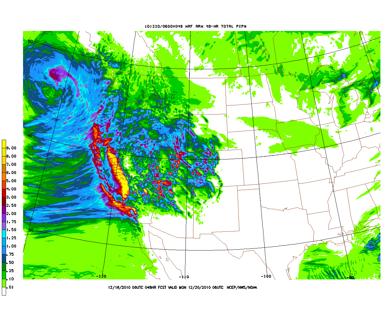
As you can plainly see below, a large pacific storm with deep moisture will spread inland towards the inter mountain region.
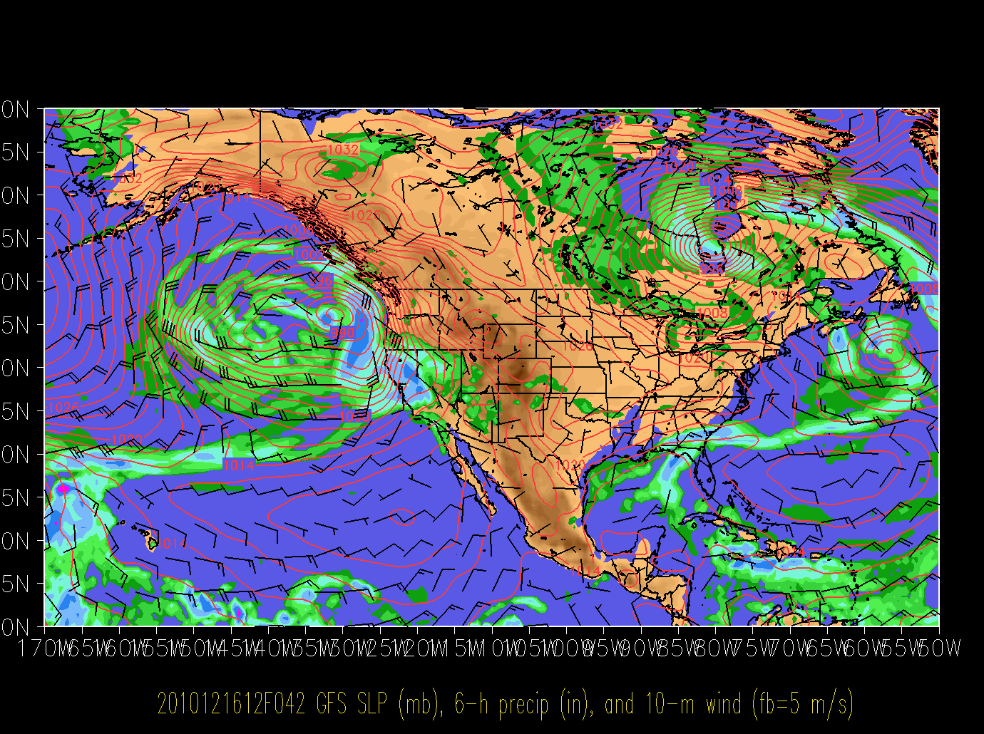
Now there are two important things about this storm. First it has tapped fairly deep subtropical moisture out over Hawaii. Some people have said it’s tapped the famed “pineapple express” firehose. I’m not so sure it’s that direct but regardless there is plenty of liquid here.
Second note the path. In UT there are two major storm tracks – storms drop down through the state from the pacific NW and storms swing into the state from Central and So. Cal. This is the path of the current storm. This means it will bring moisture in on a W/SW flow. Instead of orographic forcing affecting the NW facing slopes the best, it will affect the SW facing slopes. Also, the air column will be a few degrees warmer than normal so a denser snow is expected.
By the weekend the storm has spread well inland and precipitable moisture is well entrenched over the Wasatch front.
Now as I said there looks to be a ton of moisture with this system. Below is the NAM gridded model forecast total qpf for the storm:
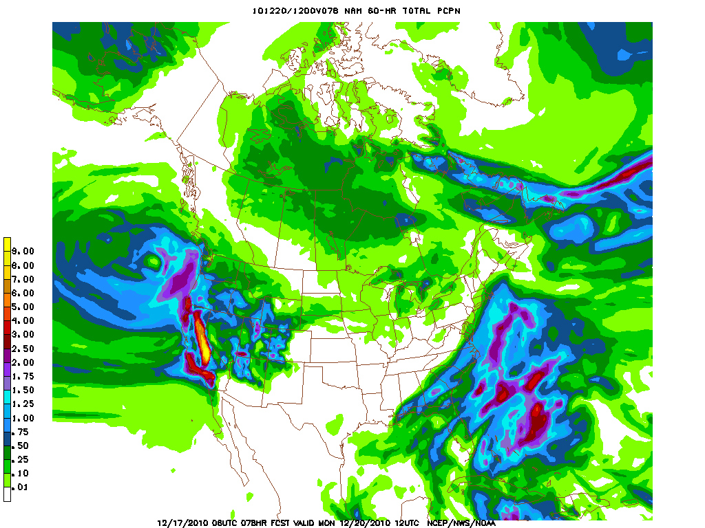
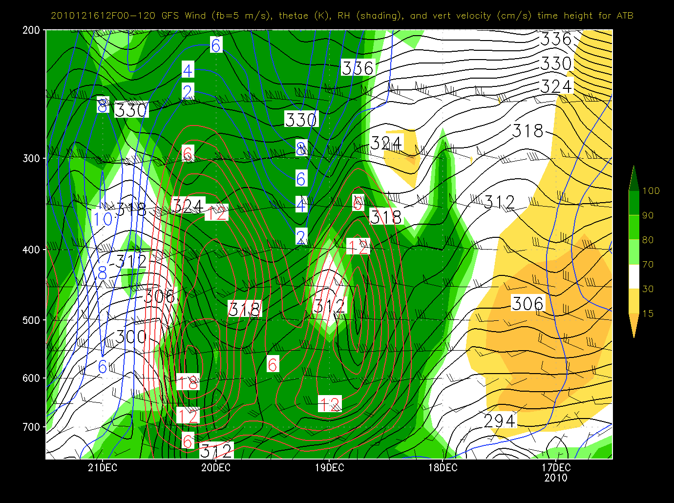
For the NAM gridded model to be estimating 2 inches of liquid over the wasatch already is SIGNIFICANT. Often precip is underdone by the gridded models in the wasatch. THis most commonly occurs when there is deep upward motion and orographic forcing that these large resolution models can’t account for. Lo’ and behold we see such UVV:
So what does this add up to?
Feets of snow. By monday I suspect somewhere between 2-3 feet of dense (by Utah standards) snow to fall along the Wasatch Range. Heaviest snow will likely fall in area’s facing west/southwest. However with no capping inversion in place along the ridgetops, any orographic snow can transport over to the NW and N facing slopes rather easily. So …yea…woot woot!
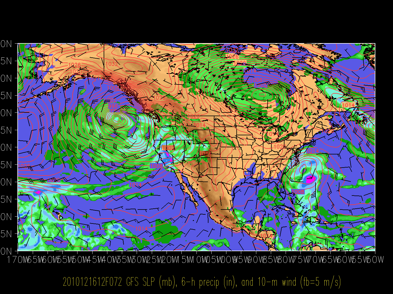
Sat. 8:00 am EST UPDATE
High Resolution gridded models are now within range of the first 70% of this event and boy are they coming in WET. (Insert joke about N.J Cougars and Bon Jovi concernt). Looking at the model output QPF below:
We see the Wasatch Range picking up an incredible 3+ inches of liquid, with heaviest amounts focused on South, Southwest and even for a time SE facing slopes. Now let me temper excitement a touch by saying the models do overdo the total moisture a bit. However it is clear that a significant amount of liquid will move into the region of the 48 hours and beyond. Feets of snow are likely. Snow levels will RISE throughout the day to almost 7500 feet with slightly lower levels along the aspects discussed below (orographic forcing actually lowers snow levels …long story…).
Monday UPDATE:
Looks like we have to take snowfall totals down a touch as snow fall ratios are incredibly below 8 to 1 in the Cottonwoods. Still a ton of moisture in this moist environ. over the next 24 hours before a front passes the region so expect another 8-10 inches or so of very heavy wet snow. Once the front passes winds will move some cooler air in and bring the snow ratios up.

5 Comments
Leave a Reply
|
|||
| Home |

-
Search
New Comments
Surfing Safari on Burlington's Booth Street | Seven Days said: “[…] lights and snapped away. Here’s a...(read more)” about Surfing the Flood
macbook repair seattle said: “macbook repair seattle Let’s get it started...(read more)” about Let’s get it started
Greg said: “Thanks for all this great info. And...(read more)” about Skiing Mt. Colden’s Trap Dike
Greg said: “Definitely late, but always welcome!” about Skiing Mt. Colden’s Trap Dike
Bob said: “[* Shield Security plugin marked this comment...(read more)” about Skiing Mt. Colden’s Trap Dike
Regular paint Maintenance said: “Regular paint Maintenance Behind The Schuss(ic) :...(read more)” about Behind The Schuss(ic)
The 2012-13 Ski Season in Photos #13 | NY Ski Blog said: “[…] tweeting about big Memorial Day snow...(read more)” about pow
ml242 said: “LuckyLuc and MadPat on the same day?...(read more)” about Deep Cover Anthropology
Twitter Feed
-
Categories
- Skiing (438)
- Weather (188)
- WTF (5)
- Quick Update (173)
- Full Trip Report (165)
- WebiGNARs (45)
- General Interest (38)
- Site News (27)
- Summer (59)
- Hiking (26)
- Swimming (15)
- Climbing (13)
- Longboarding (3)
- Whitewater Kayaking (2)
- Mountain Biking (1)
- SPA (16)
- Gear Review (8)
-
Archive
- October 2018
- June 2017
- November 2016
- October 2016
- March 2016
- January 2016
- October 2015
- February 2015
- January 2015
- December 2014
- November 2014
- October 2014
- September 2014
- July 2014
- April 2014
- March 2014
- February 2014
- January 2014
- December 2013
- November 2013
- October 2013
- September 2013
- August 2013
- June 2013
- May 2013
- April 2013
- March 2013
- February 2013
- January 2013
- December 2012
- November 2012
- October 2012
- September 2012
- August 2012
- July 2012
- June 2012
- May 2012
- April 2012
- March 2012
- February 2012
- January 2012
- December 2011
- November 2011
- October 2011
- September 2011
- August 2011
- July 2011
- June 2011
- May 2011
- April 2011
- March 2011
- February 2011
- January 2011
- December 2010
- November 2010
- October 2010
- September 2010
- August 2010
- July 2010
- June 2010
- May 2010
- April 2010
- March 2010
- February 2010
- January 2010
- December 2009
- November 2009
- October 2009
- September 2009
- August 2009
- July 2009
- June 2009
- April 2009
- March 2009
- February 2009
- January 2009
- December 2008
- November 2008
- October 2008
- April 2008
- March 2008
- February 2008
-
Friends of F.I.S.

About Us:
We are a group of powder hungry, east-coast-bred, world-traveling skiers and riders who Earn Our Turns to bring you the best stoke a click-of-the-mouse can buy.We hope our adventures inspire you to Earn Your Turns as well!
LEARN MORE

Latest Weather
When one makes meatballs, one must begin with quality meats: ...
Read more in: Meatballs! (read more)
Conductor of the Pineapple Express
wrote on December 17th, 2010 at 6:58 amJust in time to get me charged up for a dawn patrol! Toot toot!
yabyum
wrote on December 17th, 2010 at 10:04 amThe 16km infrared sat. loks a lot like the “old firehose” to me. Hope the pack holds the weight. Some layers will be suspect with the 2+” coming in.
Ben
wrote on December 18th, 2010 at 8:45 pmI’m excited!
Although all the surface facets from the last couple days of cold high pressure are going to be fun with all the new weight… Might be sticking inbounds for the next few days!
Porter Haney
wrote on December 19th, 2010 at 7:47 pmA+ skiing out there, albeit of the Sierra Cement variety. Lots of surface instabilities, ie top 12-20 inches. Noticed no deep instabilities.