
On the Homology of a Schuss
“Nihilistic” comes to mind when I’m asked what schussing is all about; you go up, you come down, and that’s about it. Don’t search for deeper meaning. It’s not there. Sometimes you come down the same thing you went up. Sometimes you come down a different thing. Either way though, you always make a closed loop (come back to where you started). Sometimes the closed loop can be continuously deformed through skiable terrain to a point.
Sometimes it cannot.
The difference is what I call the “Homology of a Schuss.”
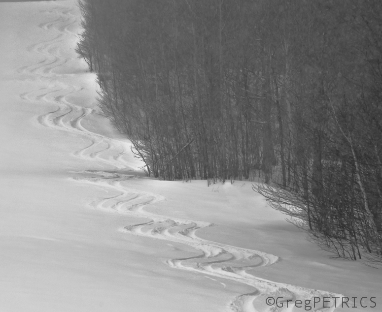
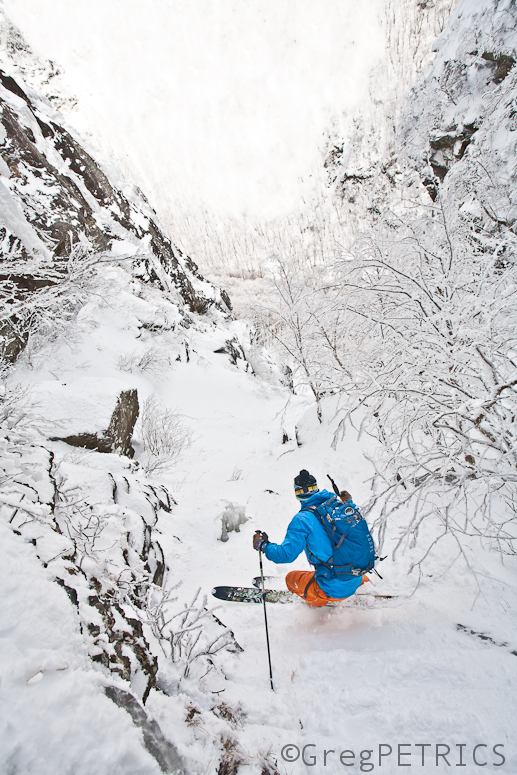
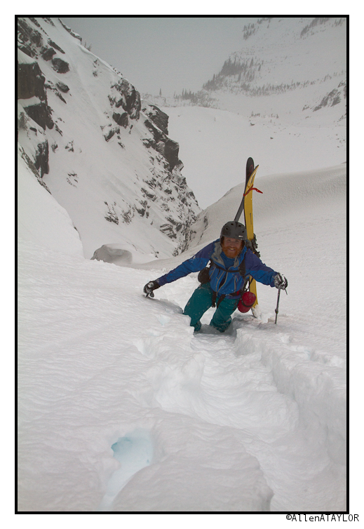
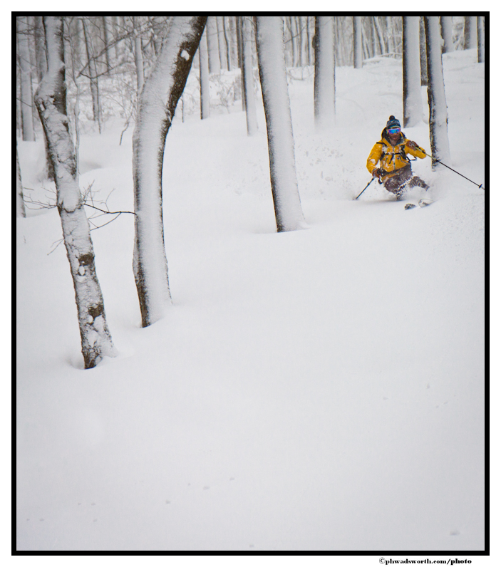
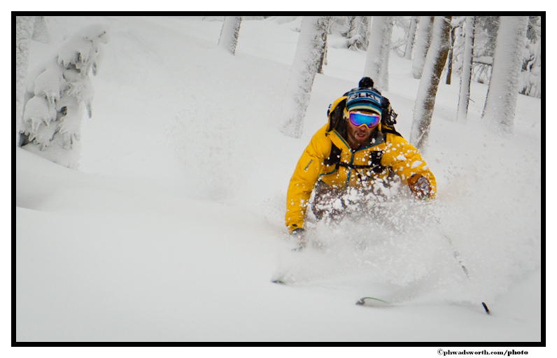
This mathematical invariant distinguishes schusses according to how many “holes” of non-skiable terrain are contained within the interior of the closed loop of the route of the schuss. Observe Jake calculating the homology of his current route.
As you can see here there is at least one “hole” of non skiable terrain between Jake and where he started. As it turns out the Homology of this is 
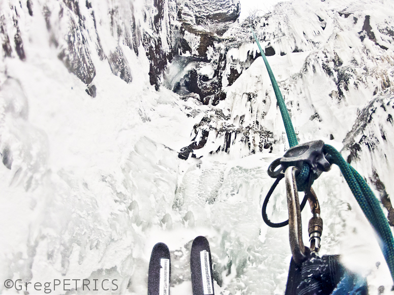
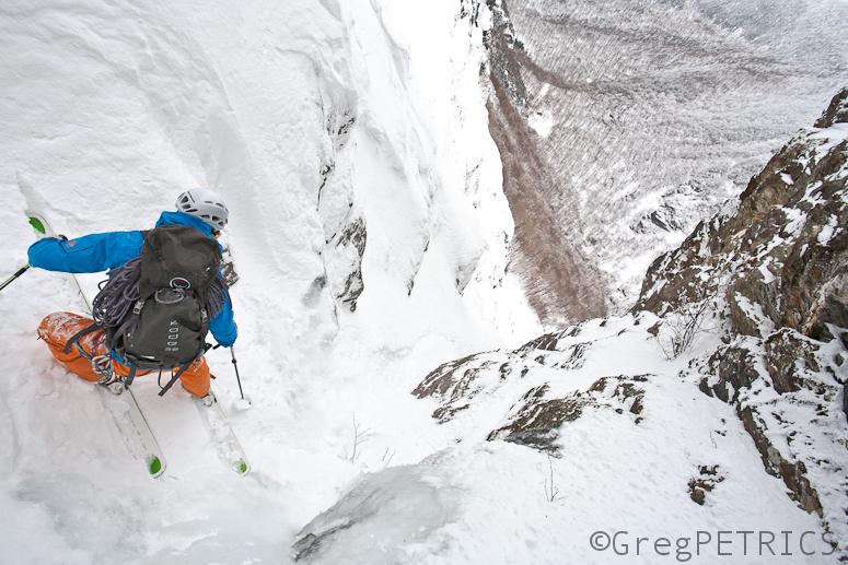
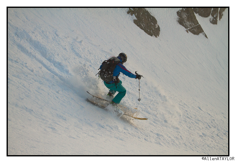
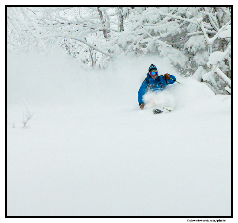
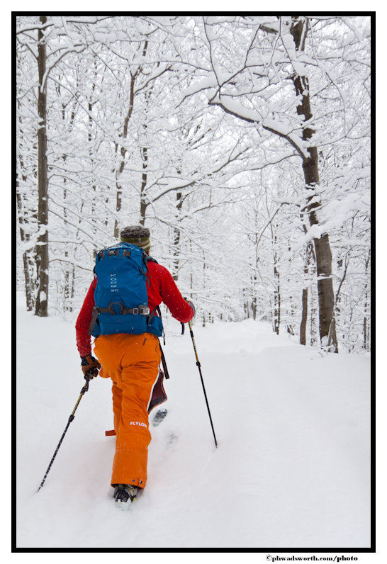
Of course, the homology of a schuss is not a perfect invariant; occasionally it fails to distinguish between two non homeomorphic schusses. Indeed the homology of the schuss pictured below is also
If you ever get confused, just remember that since we’re only working in 2 dimensions, the homology of schuss is just the abelianization of its homotopy group. I should warn you though that this fact doesn’t really help with calculations however, since the homotopy groups can be tricky to calculate in the first place.
5 Days in the Stuart Range
Hey all, I know its been a while. This has been a winter of doing many things, and for the first part of it skiing took a place on the back burner. Fortunately for me though our prime ski season is 10 months long so its only half over (I think we are headed into the good half anyways). I recently had a few days off while my ski bumming friend Brian was around so we decided to go for an extended winter camping trip into the Stuart range to ski some lines.
The trek in isn’t bad accept for some of the snow we ran into down low was extremely gloppy. It got so bad that I carried my skis for a while. Moral of the story: always bring skin wax, even in the winter.
Brian and I made Camp at Colchuck lake with the goal of knocking off a few couliors on mt Colchuck. The snow was soft and cold and at times bootpacking was a bit of a chore.
Always worth it in the end though.
This is Colchuck’s Northeast Couloir. We made it most of the way up but were turned around within 500′ of the top by a rock step.
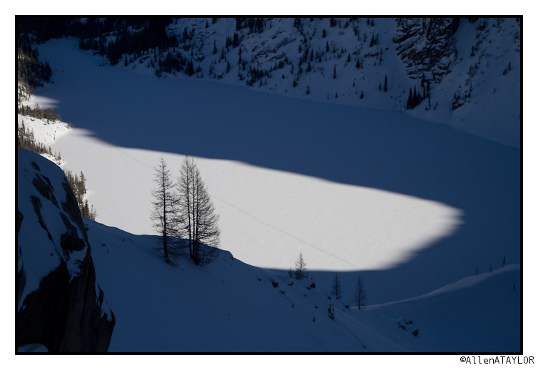
The Colchuck Glacier was a great way to end the day. There are worse things than 2500′ of wide open untracked powder. Clouds were in and out.
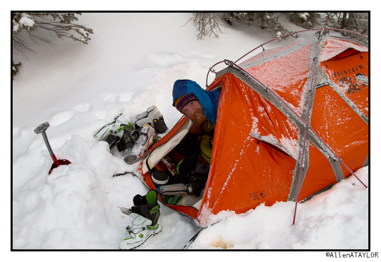
Morning 2 was cold. Here is brian emerging from the fart capsule.
We re-used our skintrack from the day before to access the North Buttress Couloir.
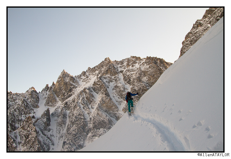
The sun came out and the weather was really startig to cooperate.
Fat and Light Take Flight: Dynafit Huascaran
Flashback. March of 2012. Vermont. In an otherwise rough season, February closes out with some dynamite powder skiing and leaves the snowpack at a downright decent level. Enter a week of record high temperatures and then cooler weather without significant precipitation. In three weeks the total pack is shrunk by 2/3 and hard surfaces rule the day.
It was right in the middle of this warmup and snow decay that I was given a pre production pair of a super wide, super light new powder ski being added to the ever-progressing line of true freeride touring products offered by Dynafit. The Huascaran; Lord of the Cordillera Blanca.
Of course, one gets such a great looking ride for the soft stuff and by reason there is no snow to give them the appropriate vetting. Par for the course, especially in these locales. I did my due diligence and gave them an AM of icy, ungroomed garbage only to learn that they do succumb to the laws of gravity. Although, they are less willing to do so with skins on (read; they are pretty light in the skin track). I convinced myself that it would be good to have a svelte (in weight, not surface area) touring powder ski to round out the quiver, and the Huascaran seemed like a worthy solider.
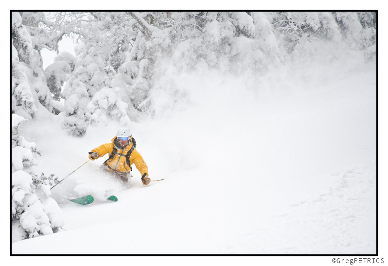
My time using the Huascaran has been highlighted by some of the best powder skiing up and down the East coast this season. Starting on Halloween in West Virginia doing the Sandy schuss.
And through this season, I have spent most any touring day with more than 10″ of fresh snow finding lines on these skis. I have not been disappointed.
On the tech side of things, the Huascaran is the first of Dynafit’s skis to add in a significant amount of tip rocker and any tail rocker at all. The tail rocker is very minimal (almost nil), and there is just a touch of camber underfoot. The camber/rocker profile strikes an interesting balance, in that to keep with the heart of Dynafit’s market the ski needs to be stiff enough and have enough edge length to allow for control and confidence in variable high alpine snow. But the ultra low camber and rocker do allow for a loose and surfy feel in powder where the tip and tail are free from hook. The tail rocker is also low enough to provide an adequately flat tail for ski anchoring.
The Huascaran also sports a multiple radius sidecut, incorporating three different radii acting on the ski’s edge. The initial 1/4 of the ski has a long 35m radius, designed for a true track in powder and to avoid powder hook. The middle half of the ski has a much tighter 20m radius for maneuverability in tight spots when the going gets tough. The bottom 1/4 of the ski has a 30m radius, again to enable smooth release in soft snow conditions.
The cold hard stats.
Coming in 4 lengths (167, 177, 186, and 196), the Huascaran has changing dimensions at each length keeping waist width ranging from 110mm to 115mm. The skis come in at under 8lbs/pair for the two shortest sizes, and just a hair over 8lbs/pair on the two longest sizes. Those are some pretty impressive weight numbers considering the surface area of the ski. Much of the weight savings can be attributed to the core and reinforcement composition used in the ski’s construction. Core material using bamboo and beech for strength and stiffness, coupled with the lower weight of paulownia and composite Iso-Core material, equals a strong, stiff, but light core. The reinforcement includes carbon, fiberglass, and thin metal reinforcement plates in the mounting zone.
I have spent time using the Huascarans with both Dynafit TLT 5 Performance boots (mostly) and Dynafit Titans. The Titans allow for much for control of the tip of the ski, especially when dealing with the relatively long 186cm length. You can more easily ski the Huascaran like the long radius/big mountain ski that it aspires to be.
With the lighter, shorter, softer TLT 5s you do a lot more skiing the middle of the ski, the central turn radius, and much more smearing. A little edge leverage is lost by having a shorter cuff on the boot. But the touring of the TLT 5 is so far superior to the Titan that some of the more aggressive skiing attributes are easily forgotten, especially going uphill for lap 4 or 5.
I must say I have been a big fan of the Huascaran. It has filled a hole in the quiver for the deep snow days. Although I think a 177 would be a little easier to snake around the VT area with my light boots, I overall do prefer the 186 for it’s east/west capabilities. Make sure you check this option out if looking for a new pow ski for your tours.
Mid-Week Storm Complex to Bring Snow to Northeast (Wed Update)
Starting on Tuesday a storm complex will move into the Northeast. From Tuesday through Thursday night we’ll see steady snowfall across all major northeast mountains as the “storm” unfolds in 4 parts. Totals will generally be in the 8-16 range with pockets 20-24(+) range when all is wrapped up Thursday.
Lets take a closer look at the event.
First a GIF:
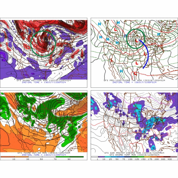
Now the explanation.
On Monday, a large storm will move into western Great Lakes. A warm front will extend east over the great lakes, and cold front will extend down into the Ohio Valley.
The Great Lakes storm – by monday evening- will have become almost vertically stacked (surface, 850, 700 and 500m low centers all on top of each other) under a very large 500mb upper atmospheric trough. The trough will move east through the day monday.
As that trough passes over the surface cold front, it will spark the development of a second low. This is Norwegian-Model cyclonic development 101. The mass divergence of air exiting the the base of the 500mb trough sparks uplift. When this uplift interacts with an area of strong temperature gradients- like a cold front- cylcogenesis is likely.
So by Monday 11:59pm we’ll have a large vertically stacked storm to our west/northwest and a newly birthed storm to our southeast. In between the two storms will be a pocket of warmer air that was sucked up and trapped by the big old low to our N/W.
By Tuesday morning, the warm pocket of air will be making zee powz through isentropic lifting over entrenched cold air. (Part 1) We saw a VERY similar process occur in the first part of Nemo. It sucked. HARD.
As tuesday rolls on, the whole complex will move generally east/northeast. The storm to our southeast will strengthen and deepen. It will track generally through Mass and So. NH, then into Maine. This is a great track for mountain pow. (Part 2)
By Tuesday night, the two lows will actually begin to combine, creating one massive and stationary low. That large complex will sit over the N/E Tuesday night into Wednesday. Notably, the winds will turn to the west after having a strange confused s/sw orientation on tuesday. Combined with a fair amount of atmospheric lift, the whole complex looks to keep the snow going thru Wednesday. (Part 3)
Finally, on Thursday, the center of storm complex will have moved off to our Northeast. The cyclonic rotation however will rotate remnants of the old low back into the N/E. With good wind flow forecasted, and plenty of moisture around, the upslope machine looks to turn on overnight Wednesday into Thursday. (Part 4).
So yea, that’s the overall picture.
Now some notes.
1) Tuesday is going to have some weird ass strong winds fron the s/sw and s/e. I cant tell you exactly what that is going to do to the snow other than this: It’s going to mess with it and pack it into some strange places.
2) That pocket of warm air that gets trapped between these two lows is just another messy, complicating factor. I could see some sleet developing on tuesday at some point as a result. At the very least it will impact the dendritic growth and we’ll see some non-fluffy snow falling.
3) Don’t be shocked if a dryslot works into this equation as well at some point Wednesday. That could easily happen as the lows spin some drier cold air from the west up our way.
Totals:
With the above notes and complexity of the forecast, I think a widespread “loose” call of 8-16 across all the mtns of the Northeast is warranted. If the parts 3 and 4 of this even play out well, I’m certain favored spots in the ADK, Greens and Whites will be looking at totals in the 20-24+ range by Thursday night.
Ok, back to the Jameson. (sorry for any errors here, I’ll clean it up in the am. About an hour ago I realized “Hey, Absinthe is green!”)
Kiss me, I’m Irish; Erin Go Braugh; Go Celts!
TUESDAY AM UPDATE
So this storm has begun. As I noted above there are strange winds some dry air pulled in between the two systems.
Currently the surface pressures look like this:
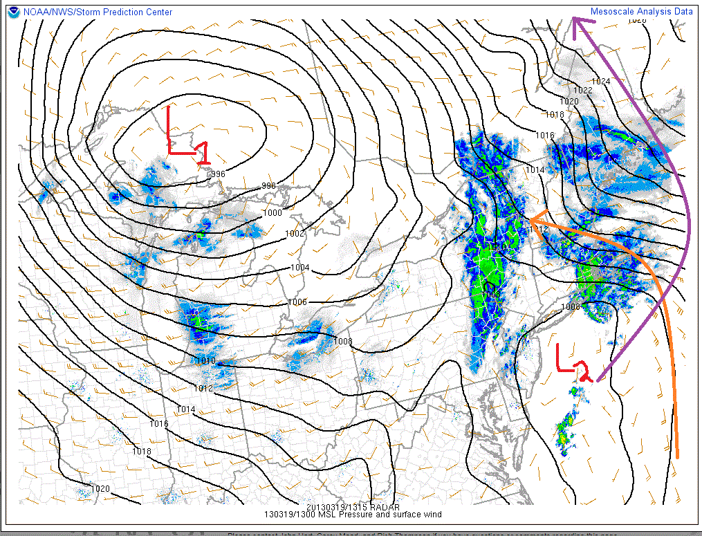
You can clearly see the dual low structure I was talking about. The old low is marked L1. The new low is marked L2. Currently a strong southeast wind is wrapping around L2 and bringing moisture and some weird wind packed snow to the Greens. L1 while really a player in making it snow right now is going to greatly affect the track of L2. L2 will wrap around to the N/NW over the next 24 hours. (Marked in purple).
As it does, the winds will shift and come out of the west, NW. This will kick off some upslope snow later tonight into tomorrow morning.
Currently totals are 5-6 range in the ADK, 4-6 range northern greens, 7-9 down at Stratton and Mt. Snow, with 3-5 in the Whites.
Still feel ok with that overall 8-16 call.
end update
Wednesday Update
Storm totals so far
Jay Peak: 26”
Burke: 15”
Smuggler’s Notch: 16”
Stowe: 14”
Bolton Valley: 15”
Mad River Glen: 19”
Sugarbush: 15”
Pico: 16”
Killington: 16”
Okemo: 16”
Bromley: 16”
Magic Mountain: 15”
Stratton: 16”
Mount Snow: 18”
Wildcat: 12″
Cannon: 10-13″
Sugarloaf: 15-18″
MTW: 16.9 (Dig at Andrew “Thief” Bynum”)
Whiteface 15″
There is still some upslope snow coming as well. 2-4/3-6 type stuff mostly. Best accums will be along the western slopes of the greens with a bit of a blocked flow and the usual down stream shadowing of the Whites from the Greens.
End Update
Conclave of March (with more Fumata Bianca)
In 1054, the Bishop of Constantinople ordered the closure of all Latin churches in Constantinople, thus beginning the east – west split known as the Great Schism. For roughly 250 years turmoil reigned as eastern and western influences battled for control of the faith. Hoping to figure out a way to resolve the split, and plan for the future, Gregory X convened the Second Council of Lyons in March 1272 (roughly a lot of years ago). An ancillary agenda item (along with the death of Thomas Aquinas) was the discussion of reforming the process of resolving states of sede vacante as concerning the Bishop of Rome.
Specifically, the Council was frustrated by the interregnum of 1268-1271 where there was no apostolic Successor to St. Peter. Prior to the Second Council of Lyons, electorate Cardinals were free to leave the conclave at their will. Accordingly, the elevation process became open to substantial political influence and public scrutiny.
Seeking to end such long election periods, and limit political influence on the College, Gregory X (also know as Stumpy Pete) decreed to the Council that cardinals were no longer allowed to leave the Conclave until the Successor to St. Peter was chosen. Of course, as we know, the decision to sequester the College of Cardinals did not end the political influence. In fact, until the 20th Century key catholic monarchs actually held a veto power known as the jus exclusivae over the election of the Bishop of Rome. (The last such “veto” occurred in 1903 when Austria communicated through it’s Cardinal Prince Kosielsko that it opposed the election of Cardinal Rampolla. Ha. Austria player on a global stage….those were the days)
Anywho, while the process has developed some over the last 800 years, the process today is much the same as it was in the 13th century. Following the death or resignation of the Bishop of Rome, a Concalve from the College of Cardinals is convened. The College must not contain more than 120 Cardinals under the age of 80. An oath is administered prior to seating the College in the Sistine Chapel. All votes are to be conducted in peace and quiet in the Chapel. The voting process may begin on the first afternoon of the conclave, but only one vote may proceed at that time. Following that Cardinals may vote up to 4 times in a day, with a maximum of 33 ballots are conducted. A Pope is elected when a Cardinal receives a super-majority of votes (2/3). Voting is to done in absolutely secrecy and any Cardinal who threatens the secrecy is subject to excommunication.
Of course, given the power granted to the Vicar, and the global influence he wields, politics are still entrenched in the process. With over 1 billion followers (or about 75% of the Justin Bieber’s fanbase….shoot me now) and Cardinals from all over the world, there are many competing influences in the election. Speculation is rampant. Currently there are elements that would like to see a the dawn of a new era through the election of a non-European Pope. A Vatican Spring if you will. Others, wish for the election of a seasoned member of the Curia; one well versed in the ways of Vatican governance so as to push through a series of much needed reforms while maintaining much of the staid ways of history.
Currently, the signals are tending towards the election of the Old Guard. In fact, many commentators have stated that when taken as a whole the influence of the Pacific and North American clergy, along with the influence of the Cardinal from Quebec, and a
colder less enthusiastic conclave the likelihood of a spring change is low. That’s not always a bad thing.
Famously, at the end of each voting voting process the ballots are burned with additives to create a fumata nera signaling no super-majority had been reached. When a successful vote occurred, the ballots were burned alone (or with extra paper) to create fumata bianca.
Of course, with our intense interest in global politics, we’ll let you know as soon as the fumata bianca starts blowing.
_________
Not less than 4 hours after this went live, the Conclave picked a new Pope, AND it snowed 4-8 along the Spine. fumata bianca bitches.
And maybe some more:
With an upper trough in place over the NE a cool and generally moist environment prevail for the next 48-72 hours. With a west wind, light orographic snows are likely today thru tomorrow morning acorss the Green and White mountains. (1-3″). Late friday, a shortwave impulse will dive into the region from the N/W. The uplift ahead of the impulse’s vortmax will enhance lift and spark heavier snow showers in the region. Right now, it looks like a 3-7 type snow is possible Friday night into Saturday along the Green Spine, with 2-4 in the ADK and Whites.
All hail Francis I, the bringer of snow, the maker of powz.

-
Search
New Comments
Surfing Safari on Burlington's Booth Street | Seven Days said: “[…] lights and snapped away. Here’s a...(read more)” about Surfing the Flood
macbook repair seattle said: “macbook repair seattle Let’s get it started...(read more)” about Let’s get it started
Greg said: “Thanks for all this great info. And...(read more)” about Skiing Mt. Colden’s Trap Dike
Greg said: “Definitely late, but always welcome!” about Skiing Mt. Colden’s Trap Dike
Bob said: “[* Shield Security plugin marked this comment...(read more)” about Skiing Mt. Colden’s Trap Dike
Regular paint Maintenance said: “Regular paint Maintenance Behind The Schuss(ic) :...(read more)” about Behind The Schuss(ic)
The 2012-13 Ski Season in Photos #13 | NY Ski Blog said: “[…] tweeting about big Memorial Day snow...(read more)” about pow
ml242 said: “LuckyLuc and MadPat on the same day?...(read more)” about Deep Cover Anthropology
Twitter Feed
-
Categories
- Skiing (438)
- Weather (188)
- WTF (5)
- Quick Update (173)
- Full Trip Report (165)
- WebiGNARs (45)
- General Interest (38)
- Site News (27)
- Summer (59)
- Hiking (26)
- Swimming (15)
- Climbing (13)
- Longboarding (3)
- Whitewater Kayaking (2)
- Mountain Biking (1)
- SPA (16)
- Gear Review (8)
-
Archive
- October 2018
- June 2017
- November 2016
- October 2016
- March 2016
- January 2016
- October 2015
- February 2015
- January 2015
- December 2014
- November 2014
- October 2014
- September 2014
- July 2014
- April 2014
- March 2014
- February 2014
- January 2014
- December 2013
- November 2013
- October 2013
- September 2013
- August 2013
- June 2013
- May 2013
- April 2013
- March 2013
- February 2013
- January 2013
- December 2012
- November 2012
- October 2012
- September 2012
- August 2012
- July 2012
- June 2012
- May 2012
- April 2012
- March 2012
- February 2012
- January 2012
- December 2011
- November 2011
- October 2011
- September 2011
- August 2011
- July 2011
- June 2011
- May 2011
- April 2011
- March 2011
- February 2011
- January 2011
- December 2010
- November 2010
- October 2010
- September 2010
- August 2010
- July 2010
- June 2010
- May 2010
- April 2010
- March 2010
- February 2010
- January 2010
- December 2009
- November 2009
- October 2009
- September 2009
- August 2009
- July 2009
- June 2009
- April 2009
- March 2009
- February 2009
- January 2009
- December 2008
- November 2008
- October 2008
- April 2008
- March 2008
- February 2008
-
Friends of F.I.S.

About Us:
We are a group of powder hungry, east-coast-bred, world-traveling skiers and riders who Earn Our Turns to bring you the best stoke a click-of-the-mouse can buy.We hope our adventures inspire you to Earn Your Turns as well!
LEARN MORE

Latest Weather
When one makes meatballs, one must begin with quality meats: ...
Read more in: Meatballs! (read more)